
 |
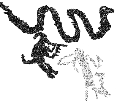 |
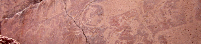
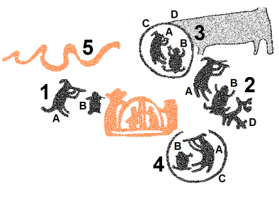
Figure 9. Unit 1 on Panel 3. Scale: height of “flute-player” is about 17 cm. Variations in shading only serve to separate the several elements and do not necessarily indicate differences in patination and/or used techniques. Drawing and photograph by Maarten van Hoek..
UNIT 2 - Figure 10
This unit actually comprise three petroglyphs. The ‘fox’ (2A in Figure 8) more clearly has just one long, backward curving appendage and holds what seems to be a ‘flute’ with two tubes. The ‘frog’ (2B) more clearly seems to be a ‘frog’, but seems to be superimposed upon a third petroglyph (2D) of uncertain character. Because of the weathered condition of the rock it is almost impossible to separate petroglyphs 2B and 2D. But this superimposition may imply that the ´frog´ is a later addition. Espinosa already observed that the ‘fox’ is hovering quite a distance over the ‘frog’. Therefore, like at Unit 1, the ‘fox’ not necessarily is associated with the ‘frog’, but ‘simply playing a wind instrument’ like many other figures at this site.
 |
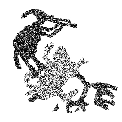 |
Figure 10. Unit 2 on Panel 3. Scale: “flute-player” is about 15 cm high. Variations in shading only serve to separate the several elements and do not necessarily indicate differences in patination and/or used techniques. Drawing and photograph by Maarten van Hoek..
UNIT 3 - Figure 11
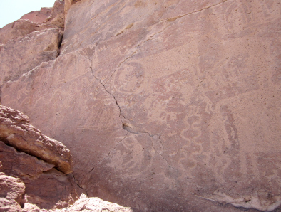
Unit 3 is special for two reasons. I consider this unit to have four elements: the ‘fox’ (3A), again with again only one appendage from the head (and contrary to the remarks by Espinosa, the ‘flute’ is visible); the very distinct ‘frog’ (3B); the circular groove enclosing these two biomorphs (3C); and finally the large, fully pecked ‘camelid’ petroglyph (3D) with two back legs instead of the one leg drawn by Espinosa. Firstly, it is remarkable that the two biomorphs are enclosed by a circular groove. This seems to imply that the two biomorphs are indeed linked (but this does not imply contemporaneity). Secondly, there is something very strange about the ‘camelid’. It has no ‘normal’ rear end and no real ‘tail’, and I cannot remember to have seen anything similar in Andean rock art. The whole rear end intimately merges with the circular groove and it seems that this has been done on purpose, especially as the difference between the techniques to produce the circular groove and the fully pecked ‘camelid’ is rather clearly visible. Moreover, there is no sign of the rear end of the ‘camelid’ inside the circular groove, which seems to exclude an instance of superimposition. All these facts seem to suggest that the ‘camelid’ is a later addition. Likewise, the ‘frog’ and the circle may have been manufactured later than the ‘fox’.
 |
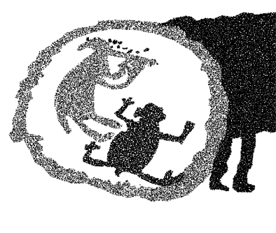 |
Figure 11. Unit 3 on Panel 3. Scale: ring is 23 cm across. Variations in shading only serve to separate the several elements and do not necessarily indicate differences in patination and/or used techniques. Drawing and photograph by Maarten van Hoek..
UNIT 4 - Figure 12
Interestingly, Unit 4 seems to be a horizontal mirror image of Unit 3 (excluding the ‘camelid’), or, as Espinosa puts it, Unit 4 has been depicted the way it would appear when Unit 3 would have been reflected in a pool of water in front of the panel (but only when viewed from the panel). The ‘frog’ petroglyph (4B) is rather distinct. The circular groove (4C) is not complete (partially because of natural features of the rock) and more poorly executed. Again, the ‘fox’ (4A) has only one appendage.
 |
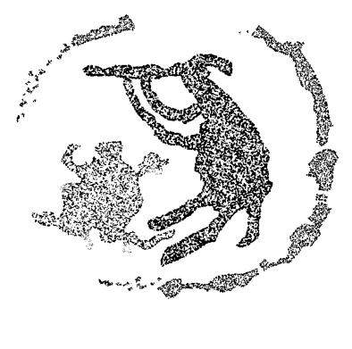 |
Figure 12. Unit 4 on Panel 3. Scale: ring is roughly 22 cm. across. Variations in shading only serve to separate the several elements and do not necessarily indicate differences in patination and/or used techniques. Drawing and photograph by Maarten van Hoek.
Finally it must be mentioned that two more possible ‘frog’ petroglyphs are present on Panel 3 of Bloque 69. Above the ‘foxes’ is a possible amphibian figure with a long, arrow-shaped tail, while at the extreme right of the panel is another possible ‘frog’ petroglyph, similar to the ones near the ‘foxes’. Also on adjacent Panel 2 of Bloque 69 is a comparable ‘frog’ petroglyph, while several other panels at Ariquilda feature ‘frog’ petroglyphs, but - as far as I know - none of those ‘frogs’ is directly associated with ‘flute players’.
Issue 2: graphical context
It is uncertain to me if indeed Espinosa himself has actually visited all the petroglyph sites of Huancarane-1 (not visited by me), Ariquilda-1 and Tarapacá-47. The main reasons for my doubt is the fact that he twice states (1996: 137 and 153) that the four ‘fox-frog’ combinations on Panel 3 of Bloque 69 are unique in the rock art repertoire of northern Chile. He states that he does not know of a similar combination at Ariquilda-1 or any other rock art site in northern Chile. Yet he graphically compares the images of Bloque 69 with two petroglyphs from other rock art sites, notably with Huancarane-1 and Tarapacá-47 (1996: Fig. 6). Unfortunately, all the drawings in his Fig. 6 have been printed mirror-wise, which once caused confusion when referring to this Fig. 6 (Van Hoek 2005: Fig. 9). Fig. 6a actually is a petroglyph from Tarapacá-47 (also incorrectly labelled as Ariquilda-1 by Chacama & Briones 1996: Fig. 2), while Fig. 6b is from Huancarane-1 (and not the other way around) and both should be mirrored horizontally.
The reason to doubt if Espinosa has actually seen the petroglyph at Tarapacá-47 in the field is the fact that he apparently reproduced the drawing of Bloque 177 by Núñez and Briones (1967: Lámina XIV-C), which only illustrates one of the three petroglyphs on this panel; only the ‘fox’. Importantly, as Núñez & Briones do not illustrate the whole panel (Figure 13B), it has been overlooked by Espinosa that the ‘zorro músico’ is ‘directing his music’ towards a ‘lizard’ and a ‘frog’. It is even possible that the ‘lizard’ petroglyph was added at a later stage and that the potential original ‘scene’ involved a ‘fox’ and a ‘frog’ in a similar juxtaposition as the four ‘scenes’ on Bloque 69 at Ariquilda-1. In any case, the ‘scene’ on Bloque 177 at Tarapacá-47 represents a most important analogy in this discussion, which has (unintentionally and possibly unknowingly) been overlooked by Espinosa.
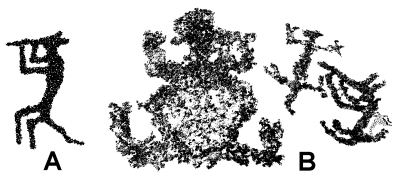
Figure 13. A: Detail from Bloque 10 at Huancarane-1 (height of the “flute-player” is about 35 cm). B: Bloque 177 at Tarapacá-47 (height of the “flute-player” is about 15 cm). Drawings by Maarten van Hoek. (A: based on Niemeyer & Schiappacasse 1981: Fig. 13b).
The ‘flute playing fox’ petroglyph on Bloque 10 at Huancarane-1 is not associated with another zoomorph (Figure 13A) and moreover has been interpreted as a ‘monkey’ (monito) by Niemeyer & Schiappacasse (1981: 74). At Tarapacá-47 at least four examples of ‘zoomorphs playing a wind instrument’ occur. On panel TAR-101 - a panel not illustrated by Núñez & Briones (1968) and thus I use my own numbering for this site - are at least two zoomorphs of uncertain species (they might be ‘foxes’) that seem to ‘play the flute’ (a relatively very small ‘flute player’ on the same panel probably is anthropomorphic). A possible example of a ‘flute playing monkey’ occurs on boulder TAR-045B (Bloque 174 by Núñez & Briones 1968 - but not illustrated by them). On Bloque 161 Núñez & Briones (1968: Lámina X-B) illustrate a petroglyph of what seems to be another ‘flute-playing monkey’ (not seen by me). All these examples underscore the fact that Andean peoples depicted ‘zoomorphs playing a wind instrument’ (see also Van Hoek 2005 for other examples of ‘biomorphs playing a wind instrument’ in Andean rock art).
Finally it must be mentioned that at Ariquilda-1 at least 22 images of ‘flute players’ are known to me to have been recorded at this site, but none seems to clearly represent a ‘zoomorph’. However, two of those anthropomorphic ‘flute players’ appear on a small, cave like panel on the north side of the valley (Panel ARQn-154 - I have used my own ARQ-numbering for the Ariquilda panels, because, unfortunately, I was never granted access to the official inventory of Ariquilda stored at the Universidad de Tarapacá, despite several promises by Juan Chacama of the Universidad de Tarapacá to help me) where they seem to be associated with ‘fleet’ of five ‘rafts’, all with human figures using an oar, while at the bottom of the panel is the petroglyph of a ‘frog’, similar to the ones on Panel 3 of Bloque 69. Only a very short distance to the SW of Panel ARQn-154 is Panel ARQn-155A, which features the petroglyph of an anthropomorphic 'flute player', which seems to be associated with another anthropomorph (compare with Unit 1). Espinosa should have mentioned these facts as they provide a significant graphical context for the alleged ‘scenes’ on Panel 3 of Bloque 69.
Issue 3: the location
The general argument raised by Espinosa is partially based on the alleged relationship between the images of ‘music producing instruments’ and running or falling water. In this respect he writes (1996: 150): ‘el panel con las representaciones estudiadas …. es parte de una gran formación rocosa que, de acuerdo al desgaste de la piedra, en épocas de lluvias debe permitir la formación de una pequeña cascada, con una caída de 6 a 7 metros, aledana al petroglifo estudiado.’
Although in an earlier publication I have confirmed the general relationship between running or falling water and the origin of music in Andean mythology (Van Hoek 2005), I have a number of observations that may challenge the conclusions by Espinosa.
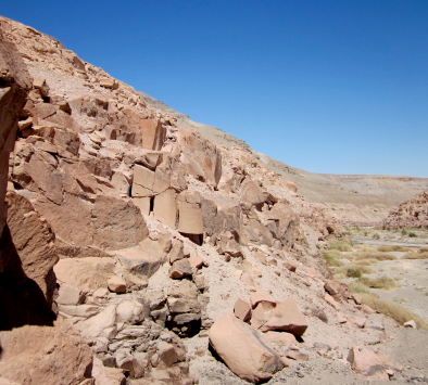
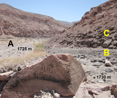
First of all, Espinosa writes that this alleged waterfall is ‘adjacent to the petroglyphs’, but he does not state how far ‘adjacent’ (east or west?) this waterfall actually is, nor does he mention whether this drop is vertical or not. Figure 14 shows the frontal view of Bloque 69. Although Espinosa does not state how many panels Bloque 69 has, I take it that there are at least four panels (but possibly six), numbered 1 to 4 from east to west (Paneles 1 and 4 may have been assigned an incorrect number by me). The area of Paneles 1 and 2 does not show any sign of a waterfall and the cliff at that point is not high enough. Panel 3 itself does not show signs of a waterfall. Panel 4 is high enough and shows signs of weathering and staining caused by water once dripping from cracks, but definitely no signs of a waterfall. Also, in my opinion the area above Panel 4 cannot collect enough water to cause a true waterfall.
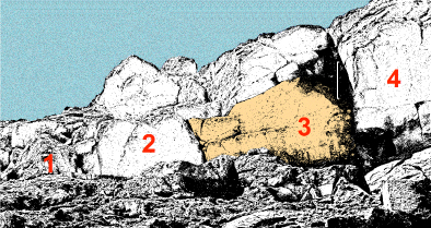
Figure 14. Drawing of Bloque 69 as observed from the NW with Panel 3 highlighted.
Scale about 1 m. (above panel 3). Drawing by Maarten van Hoek.
The most logical place to ‘find’ a waterfall is at a spot about 10 m SW of Bloque 69; the spot where a small ravine enters the Quebrada de Aroma. But when going towards that spot one first passes Bloque 70; a large cliff face with at least one large petroglyph panel that is located about 2 m lower down the ledge. From that point one can spot the mouth of a small, dry ‘Quebrada’ that empties into the Quebrada de Aroma. The narrow cleft in which this mouth is located indeed has a number of smooth rock surfaces that seem to be water-worn. This spot, also ‘overlooked’ by a few ‘minor’ petroglyph panels, could indeed have been the scene of water tumbling down a few steps during wet times.
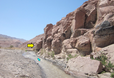
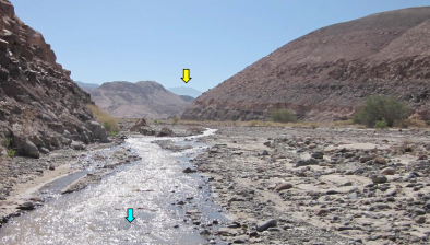
Figure 15. The area SW of Bloque 69 (indicated with a yellow arrow, but invisible from this point of view).
Photograph by Maarten van Hoek.
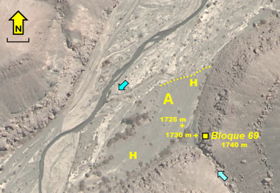
Despite the possibility of a waterfall once being present at this point I again have some reservations. Most importantly, it hardly ever rains in this area as it is located in the driest desert on earth. The only water I saw during my survey in April 2011 (Figures 1 and 15) was the river that flowed through the canyon because of heavy rains during February and March 2011 in the High Andes. The flowing water of the main stream hardly produces any sound as the valley floor slopes only very little at this point. Moreover, the main stream is located at the other (north) side of the valley and could not be heard from Bloque 69. Although the stream frequently changes its course (see Google Earth 2007 and 2010), it is unlikely that, because of the physical situation below (the higher plain level and the raised river terrace, for instance) and just north of Bloque 69, the major stream ever flowed immediately below Bloque 69. NW of Bloque 69 notably is a less disturbed area of the flood plain (H in Figure 5) that also has a higher level. The dotted line in Figure 5 indicates the north edge of that higher area which serves as a small barrier, thus diverting the stream at that point.
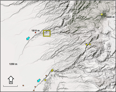
Secondly, the drainage basin of the ‘Quebrada’ SW of Bloque 70 is extremely small, notably less than 1 square km (indicated by the blue frame in Figure 16) and the run-off water from adjacent areas is emptied into the Quebrada de Aroma at other spots. Therefore, if it rains (and then I am speaking of a real downpour), the waterfall at the small ‘Quebrada’ will be in existence for only a very limited time and I moreover wonder if it ever will have carried enough water to produce a sound. There is not a vertical drop of 7 metres at that point; only a number of low cascading steps. I also wonder, if indeed a sound would have been produced during a heavy shower, whether this sound will have been audible for a person standing in front of Bloque 69. As there was no actual waterfall at the time of my inspection, I could not check the water-related acoustic properties of the site (which can be rather unpredictable). A more ‘logical’ place to manufacture this alleged water-sound related ‘scene’ would therefore have been very near the outlet of the ‘Quebrada’; for instance on Bloque 70.
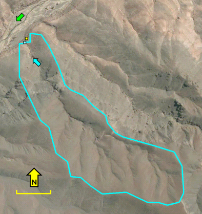
Figure 16. Drainage area of the valley near Bloque 69 (yellow square). Scale 250 m.
Drawing by Maarten van Hoek, based on Google Earth maps.
Conclusions
Four petroglyphs of zoomorphic ‘flute players’ on Panel 3 of Bloque 69 at Ariquilda-1 in the north of the Chilean Atacama Desert have been interpreted by Espinosa as ‘zorros músicos’ (see also Meyer 2006). He moreover argues that each of those laterally depicted ‘zorros músicos’ is directly associated with a petroglyph of a ‘frog’ or ‘toad’, all viewed from above. He furthermore claims that those four Units are unique in the rock art of northern Chile. In addition he argues that there is a relationship between the four Units and a nearby ‘waterfall’ and that the whole scene is a unique example of graphical inversion in Andean rock art. Based on those ideas he claims that ‘this scene is a symbolic representation which functioned as a symbol for rainmaking’ (1996: 133).
However, in this paper I have expressed a number of reservations regarding the conclusions by Espinosa. To begin with, the four Units on Panel 3 of Bloque 69 at Ariquilda-1 are not unique because of the comparable combination on Bloque 177 at Tarapacá-47, but that fact does not distract from the arguments raised by Espinosa.
My first serious reservation concerns the ‘foxes’. In my opinion it is not certain if the ‘zorros músicos’ at Ariquilda-1 truly represent foxes (the animal species). A fox has two short ears, and in this respect the petroglyphs of ‘flute playing zoomorphs’ on Bloque 177 at Tarapacá-47 and on Bloque 10 at Huancarane-1 are more convincing representations of canines, as both images ‘unequivocally’ show a ‘tail’ and two ‘ears’ (I realise however that in Andean rock art countless representations of mammals have been depicted with one ear and two legs). Also, Espinosa should have at least mentioned that the biomorph on Bloque 10 at Huancarane-1 has been identified as a ‘monkey’ by Niemeyer & Schiappacasse (1981: 74).
The ‘foxes’ on Bloque 69 on the other hand all have only one, rather long, downward-curving appendage from the head. This appendage is hardly acceptable as an ‘ear’; it looks more like some kind of headgear of a human. Also their bodies are more voluminous and their posture is different (compared with the Tarapacá-47 ‘fox’). Therefore, I would like to propose that all four ‘flute players’ on Bloque 69 may possibly represent ‘humans-in-animal-disguise’, while it remains uncertain whether indeed they depict ‘foxes’ or whatever animal species.
Another matter is the suggested correlation between the four ‘foxes’ and the four ‘frogs’. Indeed, in all four cases a ‘flute playing biomorph’ seems to be directed towards a ‘frog’, and especially in Units 3 and 4 this relationship seems to be confirmed by the circular groove that encloses the two biomorphs. However, at least in one case, at Unit 1, it is almost certain that there is no ‘frog’ involved, and, moreover, that the ‘flute playing biomorph’ may well address the ‘snake’. Therefore, Unit 1 can no longer be regarded to be part of the arguments raised by Espinosa.
Moreover, although Espinosa seems to depart from the idea that all eight biomorphs and the two circular grooves have been executed by the same ‘hand’ at the same time, this is by no means certain. What is certain is that at Ariquilda-1 several layers of rock art production occur. This is evidenced by the several styles in which especially the ‘camelids’ have been drawn on the rocks and by a number of superimpositions. This means that the possibility that the four ‘foxes’, the three ‘frogs’ and the circular grooves are not contemporary cannot be ruled out, despite the seemingly very strong cases of association. Also associations in rock art can be ‘superimposed’.
In this respect I again will observe Unit 3. First of all, there is for instance a slight difference in patination between the ‘fox’ (3A) and the ‘frog’ (3B), the ‘frog’ being more patinated. This may mean that the ‘fox’ may have been added at a later stage. The circular groove (3C) also shows differences in patination, but also in pecking technique (they have been pecked somewhat coarser) and it may be added even later.
Therefore, in addition to the contemporaneity of all 12 elements as suggested by Espinosa, I would like to acknowledge the possibility that the ‘frog’ petroglyphs represent an earlier stage and that the ‘foxes’ have been added later, possibly together with the two circular grooves, but equally those enclosing circles may be later additions still. ‘Fox’ 4A might have been manufactured purposely as a mirror image of ‘fox’ 3A and possibly this decision was based on the fundamental tenet of inversion in Andean cosmology, it is certain however that the suggested inversion of the whole scene (thus involving Units 1 to 4 as shown by Espinosa in his much idealised Fig. 14) is at least questionable.
Although the assumed relationship between the four Units and the mostly dry ‘waterfall’ nearby is most uncertain to me, I do not question the pervasive water-related or even rain-related symbolism of ‘frog’ imagery in Andean rock art. Neither do I have reservations about a possible water-related symbolism of ‘flute playing biomorphs’. Therefore the interpretation of rain-making symbolism by Espinosa may well be valid, but I question if indeed all four Units have simultaneously been manufactured to represent one anticipated and coordinated and inverted scene to express a rain-making metaphor.
Note:
Jamp’atu - Hanp’átu: The name of the Dark Cloud Constellation of the Toad. Its terrestrial counterpart is Bufo spinulosus, which tolerates dry altitude very well and breeds principally at the onset of the rainy season. This toad burrows in the earth during the cold/dry season to re-emerge with the warm/rainy season. The celestial toad rises into the sky in the early morning just after terrestrial toads have emerged from their long period of subterranean hibernation and just at the time of their most intense croaking and mating period. (Source: http://www.incaglossary.org/ - NB: Copy and Paste this URL to get access).
Acknowledgement
I am indebted to my wife Elles for her assistance during our visits to Ariquilda and Tarapacá.
![]()
—¿Preguntas, comentarios? escriba a: rupestreweb@yahoogroups.com—
Cómo citar este artículo:
Van Hoek, Maarten. The case of Panel 3 - Bloque 69 - Ariquilda-1, Chile. En Rupestreweb, http://www.rupestreweb.info/Ariquilda.html
2013
BIBLIOGRAFÍA (references in blue are links)
Chacama, J. M. & L. E. Briones. 1996. Arte Rupestre en el Desierto Tarapaqueño, Norte de Chile. Boletín de SIARB. Vol. 10; pp 41 - 49. La Paz, Bolivia.
Espinosa, G. 1996. Lari y Jamp'atu. Ritual de luvia y simbolismo andino en un escena de arte rupestre e Ariquilda-1. Norte de Chile. Chungara. Revista de Antropología Chilena. Vol. 28 - No’s. 1-2; pp 133 - 157. Arica, Chile.
Niemeyer, H. & V. Schiappacasse. 1981. Aportes al conocimiento del Período Tardío del extremo norte de Chile: Análisis del sector Huancarane del valle de Camarones. Chungara. Revista de Antropología Chilena. Vol. 7; pp 3 -103. Arica, Chile.
Meyer, J. 2006. De petroglifos, zorros y Tijeras.
Núñez, A. Lautaro, & L. Briones. 1967-8. Petroglifos del sitio Tarapacá-47 (Provincia de Tarapacá). Estudios Arqueológicos. Vol. 3-4; pp 43 - 75. Universidad de Chile. Antofagasta, Chile.
Reinhard, J. 2002. A high altitude archaeological survey in northern Chile. Chungara. Revista de Antropología Chilena. Vol. 34 - No 1; pp 85 - 99. Arica, Chile.
Van Hoek, M. 2005. Biomorphs ‘playing a wind instrument’ in Andean rock art. Rock Art Research. Vol. 22-1, pp 23 - 34. Melbourne, Australia.