A critical
analysis of the rock art on boulder CNG-020, Cerro Negro, Chicama, La Libertad,
Perú
Maarten van Hoek rockart@home.nl
Introduction to the paper
When my wife and I visited the Chicama Valley in
northern Peru, shortly after generously having received his 2006-book
personally from Daniel Castillo Benites, we were unable to locate the Cerro
Negro site. Locals told us that it was located “somewhere behind that mountain
range”, pointing to Cerro de la Botella. Unfortunately time was limited at that
time and we did not attempt to trace the site without knowing were it was.
Later I wrote to Daniel about the problem and he was so kind to confirm the
correct location of Cerro Negro on a Google Earth map. Indeed, when my wife and
I visited Chicama again, several years later, the site proved to be positioned
indeed much further east from the Chicama Valley than we anticipated earlier.
Therefore, without the sympathetic help of Daniel Castillo Benites we would not
have found Cerro Negro.
Introduction to the video
A paper about a highly graphical subject such as rock
art cannot do without illustrations. In almost every publication these
illustrations are provided at certain points throughout the text. This time
however, I have decided to offer all graphics in a video called: El
caso de la Roca CNG-020, Cerro Negro, Chicama, La Libertad, Perú; Un Análisis
Crítico. This not-public video is only accessible via the web site of Rupestreweb.
Please do not forward this link to irresponsible people in order to protect the
site from looting and vandalism.
The text in the video is Spanish, so the video
presentation is useful to Spanish-speaking people as well. An advantage is that
one can include moving pictures and put emphases on certain aspects. A
‘negative’ consequence may be that one has to use the video next to the paper
(put the video on ‘pause’ when necessary). This video contains all (numbered)
illustrations referred to in the text and additional un-numbered graphics and
film fragments. Although indeed all Figures appear in the Video (referred to in
the paper below as Video Figure X), I
also decided to include a number of the illustrations throughout the text below
(referred to in the paper as Figure X). This combined illustrated-paper/video
presentation is an experiment for me and therefore I appreciate receiving your
constructive comments regarding this kind of production.
Cerro Negro
Cerro Negro is a small rock art site in the Chicama
drainage in the north of Peru. It is located at the southern edge of an
extensive, flat and slightly sloping area, called Playa Cuculí. Although
Antonio Núñez Jiménez (1986: 321) and other authors describe especially one
petroglyph panel that is directly overlooking the Chicama Valley (La Piedra de la Compartición: see Video Figure 18), they all seem to have
been unaware of the rich gamut of rock art sites at ‘hidden’ Playa Cuculí (of
which Cerro Negro is the major locale). Even though it is unknown to me who
actually first discovered the Playa Cuculí - Cerro Negro petroglyphs, they only
seemingly have been reported rather recently. Notably, according to the
Peruvian archaeologist Daniel Seuart Castillo Benites (2006: 11) this site -
and several others in the Alto Chicama area - was registered for the first time
by the INC on the 21st of April 1993, as record 306-93 INC-LL (Insituto Nacional de Cultura - La
Libertad). After this first official registration, Castillo Benites was the
first scholar to write some reports on the rock art of this area, which is
often referred to as Pampas de Jagüey or Pampa de Jaguay (1993, 1994).
Apparently also Rainer Hostnig was not aware of this
1993-registration as, ten years later, he did not include Cerro Negro into the
La Libertad section of his Arte Rupestre
del Perú: Inventario Nacional (2003). However, he describes the site of Playa Cuculí (2003: 207), referring
to an earlier paper by Castillo Benites (1994: 28), simultaneously stating that
several stones from Playa Cuculí had been moved to the University Museum at
Trujillo and affirming that some stones are now in possession of private
persons. From his description it is not clear if this account also concerns
stones from Cerro Negro. Yet, in his Inventario
Nacional Hostnig includes four photographs of petroglyph boulders that are
definitely located at Cerro Negro. These photos had been supplied to him by
Castillo Benites, but unfortunately all four photos have incorrect captions.
Three Cerro Negro boulders have incorrectly (but unknowingly) been labelled by
Hostnig as Piedra de la Compartición (Hostnig 2003: 212, 215), which is the name of a rock art site only 2.7 km NW
of Cerro Negro (see Video Figure 18);
and one boulder as Cerro El Vagón, Alto
de la Guitarra (Hostnig 2003: 215), which actually are the names of two
different rock art sites located respectively 51 and 57 km south of Cerro Negro
(for the exact locations of El Vagón and Alto de la Guitarra see Google
Earth Map).
Then, in November 2004, Daniel Castillo Benites
presented a paper about Cerro Negro on the Primer
Simposio Nacional de Arte Rupestre held at the city of Cusco, Peru. In this
paper, called “Petroglifos en Cerro
Negro, Playa Cuculí, Valle Chicama - Perú”, Castillo Benites stated that
information about Cerro Negro had not been previously published (Castillo
Benites in: Hostnig 2004: 24; Castillo Benites 2007: 24). Only two years later
Castillo Benites published a small but useful book about the rock art of the
Chicama Drainage, lavishly illustrated with black and white drawings, in which
he repeated his claim (Castillo Benites 2006: 11). However, his statement that
no information about rock art at Cerro Negro existed before 1993 was premature.
In his web site Arqueologia de Perú Castillo Benites states
the following (ignore the typo; there is no 1940 publication by Disselhoff): Pampas de Jaguey dentro de la literatura
arqueológica solamente se detallaba la existencia de un solo petroglifo, el de "La
Compartición " o más conocido como La firma del Diablo, así lo llamaban
tambien: Disselholf 1940, Krickeberg 1949, Ishida 1955, quien lo mencionan como
una piedra de contenido chavinesco. Indeed, as early as 1949 Walter Krickeberg mentioned
the existence of rock art in this area when he included Chicama in a short list
of rock art sites in Peru (Linares Málaga (1978: 379): Pampas de Jaguey over the Chicama Valley, near the capital of the
Department of Libertad. However, Castillo Benites rightly affirms that
these references to Chicama rock art only concern the better known petroglyph
panel of La Compartición (see Video Figure 18), and thus not Cerro Negro.
However, the late Eloy Linares Málaga, a renowned rock
art researcher from Arequipa in the south of Peru, illustrates a petroglyph
boulder (1999: 91; Esq. 31) that
definitely is from Cerro Negro and, more importantly, his drawing has the
following caption including a date: Petroglifos
de “Alto Chicama” (E. Linares Málaga -1965), which proves
that the site must have been known long before Castillo Benites investigated
the area. I do not know if Linares Málaga has visited the area himself or that
he made his sketch after having seen - at home - a photograph of the stone, but
it is known that Linares Málaga described and/or illustrated many rock art
panels found throughout Peru without ever having seen them in situ, as Disselhoff remarks: “Mayoría de estos sitios nunca ha visto personalmente” - “Den weitaus Grössten Teil von ihnen hat er
nie selbst gesehen” (Disselhoff 1971a; 1971b: 35). Nevertheless, it is
certain that the rock art site of Cerro Negro was identified before 1965.
It is this very Cerro Negro boulder, illustrated by
Linares Málaga (see Figure 5), that is the subject of my current paper. I
carefully examined this very boulder in 2012 and labelled it CNG-020 (Cerro
Negro - Boulder 20), as in his 2006 publication Castillo Benites did not assign
numbers to the individual stones at Cerro Negro, or any other rock art site in
Chicama.
Location of Cerro Negro
Cerro Negro is located in the extreme NE part of the
Province of Ascope, District of Chicama, 53 km due north of the capital
Trujillo (for location maps see the introduction of the Video and especially Video Figures 1 to 4)) of the Department of
La Libertad, northern Peru. There are, of course, many more places in the Andes
that are called Cerro Negro (literally meaning ‘Black Hill’). However, the subject
of this paper, the rock art site on the inconspicuous hillock of Cerro Negro,
is only an extremely small part of Playa Cuculí. This ‘playa’ (it is not a beach) in turn is part of the drainage of the
Río Chicama.
The Chicama Valley is rich in rock art sites. No less
than 21 sites have been recorded (Castillo Benites 2006: Fig. 14) in a 72 km
stretch along the Río Chicama from Roma (in the west) to Zapotal, a rock art
site overlooking the Río Huancay in the east (however, Castillo Benites does
not include Zapotal in his 2006 book). Figure 1 shows all rock art sites known
to me to have been recorded in the Chicama drainage (situation in February
2014). The green square in Figure 1 indicates the location of Cerro Negro and
Playa Cuculí; yellow squares concern rock painting sites; blue squares denote
other petroglyph sites. Together with Chuquillanqui (with probably 111
decorated boulders or more), Cerro Negro is one of the only two sites in the
Chicama drainage with more than 50 petroglyph boulders.
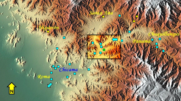 |
Figure 1. Rock art in the
Chicama drainage, northern Peru. Map © by Maarten van Hoek
(based on Google Earth Relief Maps). Framed area: Video Figure 2.
|
The petroglyph site of Cerro Negro (Site 1 in Video Figure 2; green sqaures: estimated
positions) is found about 2 km east of the Chicama Valley, at the very southern
limit of Playa Cuculí. In the neighbourhood are several other petroglyphs sites
(which often - together with Cerro Negro - are collectively referred to as
Pampas de Jagüey). Site 2: Playa Cuculí A and B; Site 3: Aldea Aglutinada; Site 4: Cafetal;
Site 5: Shimba; Site 6: La Firma del Diablo (see Video Figure 18); Site 7: Colón; Site 8: La Huaca. Sites 5 and 7 are located on the opposite
(western and northern) bank of the river Chicama, while Site 8 is actually
located in the valley of Río Seco de Santa Ana. More information about those
sites, together with illustrations, is found in the publications by Castillo
Benites.
Playa Cuculí is a gently northwest sloping plain that
is located between the two westward pointing mountain ridges of Cerro Salavin.
The northern ridge of Cerro Salavin is also called Cerro las Cabras, but its
west end is better known locally as Cerro (de) la Botella because of a conspicuous
(natural) bottle-shaped area on its extreme western slope that immediately
overlooks the Chicama Valley. Playa Cuculí is a rather flat, gravely area, cut
by several shallow gullies, which measures approximately 800 m (N-S) by 2000 m
(E-W). The site is invisible from the main road in the Chicama valley, but
glimpses of the Chicama Valley are visible from certain points at and near
Cerro Negro (see Video).
One can reach the site from the valley of the Río
Chicama after 2 km when following the dry river gully of the Quebrada de Ghaspa
(please, first ask permission to enter any private property and beware of
dogs). Despite the remote location there is evidence of areas having been
looted. Especially the zone in front of Boulder CNG-009 has severely been disturbed.
Several stones may have been displaced by natural or anthropic agents.
Vandalism in the form of graffiti is virtually absent, although some
petroglyphs (?) are almost un-patinated.
Playa Cuculí (Video Figure 3; red squares: estimated positions) is positioned between two major quebradas (dry river systems). In the
north the Quebrada de Maquiavelló forms the northern limit of Playa Cuculí.
This dry river system runs west and joins the Río Chicama directly south of the
‘bottle’ at Cerro la Botella (visible just below the C of Cerro). In the south
the Quebrada de Ghaspa forms the southern limit. This quebrada also runs west and is located at the very southern foot of
Cerro Salavin. The rock art of Cerro Negro is found on both sides of the Quebrada de Ghaspa, at a point where two
tributaries (initially running north and NW from the steeper slopes of Cerro
Salavin) converge and turn west. Altogether the area with petroglyph boulders
indicated in Video Figure 4 roughly
measures 100 m (E-W) by 200 m (N-S), yielding only 20.000 m2 (which
is very small compared with the approximately 2.000.000 m2 of the
petroglyph site of Toro Muerto in the south of Peru). However, areas adjacent
to the hill may well have more petroglyph stones.
There are three groups of petroglyph boulders at Cerro
Negro. The locations of the petroglyph boulders indicated with a green square
in Video Figure 4 are rather
accurately indicated (showing numbers), while the red squares (not showing the
numbers) concern the estimated positions of the other petroglyph boulders. The
northern group (N in Video Figure 4)
is separated by the gully of the Quebrada de Ghaspa from the two other groups
on the hill slopes of Cerro Negro. Group N comprises at least eight petroglyph
boulders (CNG-001 to 008) that are found on the edge of the flat part north of
the quebrada (Playa Cuculí) and on
the steep northern slope of the quebrada (see Video). A small, portable fragment of stone with a circular
petroglyph (CNG-044) was found by us a little north of the quebrada on the flat expanse of Playa Cuculí very near the low
remains of a small, ancient circular structure (see Video Figure 22). This fragment may represent part of a removed
(stolen?) boulder or may have been part of the circular structure; it certainly
is not in situ (it was left on the
site by us after having made a photograph of the fragment).
However, most petroglyph boulders (and images) are
found on the NE slopes of a small hill just SE of the quebrada (M in Video Figure 4). This hill is Cerro Negro, named after the darker (but certainly not
black) colour of the stones and earth that tops the hill. Group M on Cerro
Negro is located directly SE of the quebrada,
more or less opposite Group N. At least 18 petroglyph boulders (CNG-009 to
CNG-026) have been recorded by us at this spot. A short distance further south
and located on the east and SE slopes is the southernmost group (S in Video Figure 4) with at least 17
decorated boulders. Boulder CNG-020 is found in Group M at Cerro Negro at about
530 m O.D., while the flat valley floor of the Quebrada de Ghaspa at that point
is at about 520 m.
The Rock Art at Cerro Negro
Up to now, the best inventory of the rock art at Cerro
Negro was published by Castillo Benites in 2006. This Peruvian archaeologist,
deeply committed to the recording and preservation of Andean rock art,
published 45 black-and-white illustrations of rock art panels at this site, and
included one drawing of a geoglyph at Cerro Negro that I have not seen (2006:
Figs 75 to 120). A difficulty with the registration by Castillo Benites is that
in some cases petroglyph panels that actually occur on one boulder have been
illustrated separately, giving the unwanted impression that they concern two
individual boulders. This is definitely the case with his Figs 23 and 27 (Cerro
San Antonio) and Figs 160 and 161 (Panamá) (Castillo Benites 2006). Thus the
same confusion may exist with illustrations of other sites, as well with his
Cerro Negro drawings.
In 2012 my wife Elles and I recorded 44 boulders (with
altogether 49 panels) with petroglyphs, including 16 boulders (20 panels) that
have not been illustrated by Castillo Benites, while we did not see 17 panels
illustrated by Castillo Benites (they may have been overlooked by us or they
may be located elsewhere in the area). It is therefore very likely that the
grand total of petroglyph boulders at Cerro Negro exceeds 61 stones (comprising
at least 66 panels).
The site has a mix of boulders with only one
petroglyph (one image or one groove) and panels that are literally crowded with
images and grooves. The images include abstract symbols (like spirals, crosses,
circles and other, often ‘randomly’ arranged groove patterns) and figurative
art, including images of zoomorphs (like fish, monkeys, birds and snakes) and
anthropomorphs and some isolated anthropomorphic masks or heads. There may be a
few images of plants as well, but at least one of these ‘plant-like’
petroglyphs may depict something completely different and unique. I will discuss this petroglyph further on. Instances of
superimposition occur, but are rare. Most petroglyphs are deeply patinated, but
a few images clearly show less patination. A few petroglyphs are either recent
(vandalism?) or may have been re-pecked at a later, even recent period.
Renderings of Boulder CNG-020
The first publication of a graphic of the petroglyphs
on Boulder CNG-020 that I know of, appears in a work by Linares Málaga (1999:
91; Esq. 31). This drawing by Linares Málaga (Figure 5) is dated 1965. However,
his rendering (only a very rough, very inaccurate sketch that is possibly based
on a rather vague photograph), is of very little scientific value. It is only
interesting for comparative purposes and because its caption reveals the early
date of 1965.
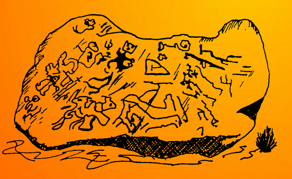 |
Figure 5. The petroglyphs on
Boulder CNG-020, Cerro Negro, northern Peru.
Drawing by Eloy Linares
Málaga (1965).
|
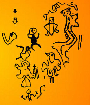 |
Figure 6. The petroglyphs on
Boulder CNG-020, Cerro Negro, northern Peru.
Drawing by Daniel Castillo
Benites (2006) (north arrow and slope-arrow added by me).
|
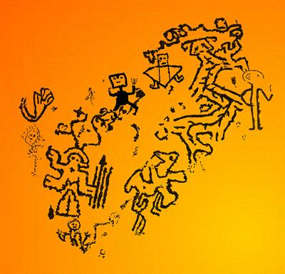 |
Figure 7. The petroglyphs on
Boulder CNG-020, Cerro Negro, northern Peru.
Drawing ©
by Maarten van Hoek (2014).
|
The second publication of the petroglyphs on Boulder
CNG-020 (Figure 6) concerns the drawing by Castillo Benites (2006: Fig 110).
Although his book is certainly useful, the illustrations by Castillo Benites
are often too small (especially of the larger panels) and thus often
inaccurate, incomplete (at least six of his black-and-white renderings of
panels at Cerro Negro are incomplete) and sometimes even incorrect, especially
regarding specific but important details (at least six of his drawings of
panels at Cerro Negro are incorrect, while one drawing [2006: Fig. 114] should
be mirrored). Castillo Benites only has drawn the images; not the stone edges
(except for his Fig. 80, which I have not seen), cracks and other natural
features of the stone. Another disadvantage is that Castillo Benites used the
colour black to indicate both pecked and incised parts, superficial and deep
parts, light pecking and coarse pecking, certain and doubtful features and,
finally, deeply patinated and later features (including recent markings). Often
however, such differences are essential to recognise idiosyncrasies and to
access their possible explanations and chronology. Figure 7 (above) offers my
interpretation of the petroglyphs on Boulder CNG-020.
Boulder CNG-035
There is one question
that immediately springs to mind when scanning the discrepancies in the three
illustrations of Boulder CNG-020. Are such differing details important? Yes,
they are! I can present several instances where inaccurate or incorrect
drawings of Andean rock art images have lead to completely false
interpretations. Any sincere rock art scientist will admit that it is
impossible to present a consistent and constructive interpretation upon
inaccurate illustrations. Such
differences are too important to ignore, especially as they often lead to
incorrect interpretations. To illustrate the difference between a drawing by
Castillo Benites and the reality, I will briefly describe another boulder,
CNG-035, which is located in Group S below the top of Cerro Negro at its SE
side (see Video Figure 4). Similar
problems occur at Boulder CNG-020.
Castillo Benites (2006: Fig: 100) illustrates three petroglyphs
on Boulder CNG-035 (marked A, B and C in Figure 8A) that all are in the correct
position. However, petroglyph A clearly differs in several details (Figure 8B).
Apart from some minor discrepancies the upper side-groove proves to have five
short grooves (instead of four), while the lower groove has four (instead of
five), one of which ends in a short curl. Petroglyph B does not have four
internal dots but three, while the right end is closed and features a short
groove that may depict the mouth of some zoomorph, although the whole may well
represent an isolated leg (severed? unfinished?) as has been suggested by
Castillo Benites. Most conflicting however is petroglyph C that has been
interpreted by Castillo Benites as an apparent ‘head’ (cabeza). However, petroglyph C most likely depicts a biomorph with
a head (with eyes, nose and mouth and two short, horn-like appendages) and a
limbless body enclosing four small dots, a circle and one or two short grooves.
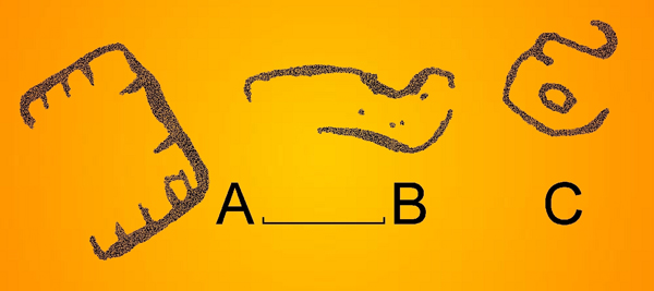 |
Figure 8A. The petroglyphs on
Boulder CNG-035, Cerro Negro, northern Peru.
Drawing by Daniel Castillo
Benites (2006).
|
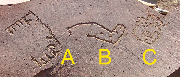 |
Figure 8B. The petroglyphs on
Boulder CNG-035, Cerro Negro, northern Peru.
Photograph
© by Maarten van Hoek (2014).
|
Boulder CNG-020
Boulder CNG-020 (Video Figure 9A and 9B), like most of the boulders at Cerro Negro, is a
purple-red-brown stone. It has a large, rather smooth and flat surface (Figure
9). It measures approximately 130 cm in length, 90 cm in width and only 5 to 30
cm in thickness (this slightly sloping stone probably is partially buried). The
slab is lying on a NNE slope and its decorated panel faces north and upwards.
Some very fine cracks and veins run across the stone. Like most other stones at
Cerro Negro, Boulder CNG-020 has sharp edges and flat fractures indicating that
no significant water erosion ever occurred at this spot. I regard the stone to
be in situ.
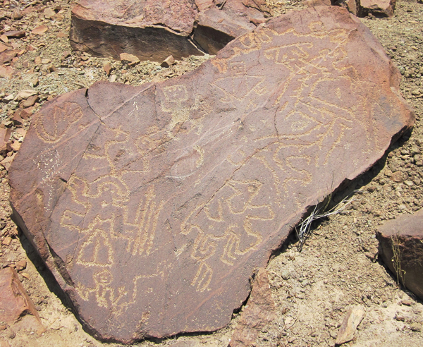 |
Figure 9. Boulder CNG-020,
Cerro Negro, northern Peru. Notice the difference in patination.
Photograph
© by Maarten van Hoek (2014). |
The Petroglyphs on Boulder CNG-020
Although much better than the rough sketch by Eloy
Linares Málaga, the illustration by Castillo Benites (Figure 6) still shows a
large number of inaccuracies, while one large image of an anthropomorphic
figure and some other markings are missing. Moreover, the relative positions
and the shapes of the petroglyphs are inaccurate. It seems to me that Castillo
Benites made his sketch from an oblique photograph, or in the field while
observing the petroglyphs.
The following descriptions of the twelve major images
on Boulder CNG-020 are based on my drawing of the stone (which is based on my -
obliquely taken - photograph) that - regarding minor details - may be
incomplete/inaccurate as well, also because it sometimes was impossible to distinguish
between anthropic pecking and natural features.
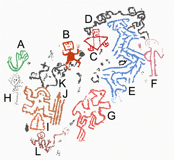
There are twelve major petroglyphs (Elements) on
Boulder CNG-020 (Figure 11) and a number of small amorphous markings (some of
which may even natural). Each major Element has been assigned a letter (A to L;
each indicated by a different colour to (subjectively) separate an Element from
its neighbour). Each Element will be described separately. All petroglyphs
(except for most of Element B and a detail in Element J) have been pecked out
in outline. Indeed, all major images and minor amorphous markings have been
pecked (or hacked), although some fine lines (like some digits) may have been
scratched or incised.
|
Figure 11. The twelve
Elements on Boulder CNG-020, Cerro Negro, northern Peru.
Drawing ©
by Maarten van Hoek (2014).
|
Element A comprises two parallel lines, curved like
an arm, which end in a configuration of lines that seem to represent a ‘fist’
(with apparently six ‘fingers’, though). It is no exception in Andean rock art
to find images of zoomorphs or anthropomorphs with three or four and even with
six or seven digits. Also, petroglyphs of severed (?) limbs (arms and legs)
have also been reported, for instance at Cerro Negro (Figure 8-B; Castillo
Benites 2006: Figs 77 and 78) and on Boulder PAL-137 at Palamenco, a rock art
site 152 km further SE. This practice of depicting severed body parts may be
related to the gruesome iconography of Cerro Sechín, a Formative Period temple
complex in Casma, 216 km SSE.
Element B is the only petroglyph that has largely
been fully pecked. Only the rectangular head is outlined and features a short
nose, two dots for eyes and a groove for a mouth. The fully frontally depicted
anthropomorph is in a typical position with both arms raised. It is possible
that once both hands were visible as very faint traces of (incised?) digits are
visible. This is also the only petroglyph on Boulder CNG-020 that has been
superimposed upon earlier grooves (of Element K) and - tellingly - Element B
definitely is less deeply patinated. It most likely is a later addition. A
similar figure appears on Boulder CNG-014, but this figure clearly has a small tumi on the rectangular head (see Video Figure 20). The figure on CNG-014
may therefore be of Moche or Chimú origin (and thus the anthropomorph on
Boulder CNG-020 may be of Moche or Chimú manufacture as well). A small tumi-shaped petroglyph appears on
Boulder CNG-010 (not illustrated by Castillo Benites 2006: Fig. 114). It also
is less deeply patinated.
Element C is a unique image (Video Figure 12). This fully frontally depicted biomorph may
represent a conflation between an anthropomorph and a (flying?) zoomorph; a
bird, a bat. It may even represent a ray-man. It seems to have an
anthropomorphic, rectangular head (with two eyes and a mouth) and two
‘human-looking’ legs. The body comprises a large triangle enclosing two
parallel grooves. This petroglyph is also less deeply patinated and may be of
the same date as its neighbour, Element B.
Element D is an elongated groove pattern with several
curls. It seems to connect Elements E and F (but this may be a coincidence and
not premeditated). This kind of irregular and non-figurative groove pattern is
rather common at Cerro Negro and at other sites in the Chicama Drainage in
general. In some cases however this type of groove pattern seems to
include/represent ‘hidden’ biomorphic features (like Element G).
Element E is a most interesting feature (Video Figure 13). It is the petroglyph
of a ‘feathered snake’ seen in bird’s-eye-view (from above). Unfortunately its
unique character is not fully appreciated in the sketch by Castillo Benites
(while the snake is completely unrecognisable in the sketch by Linares Málaga).
The trapezoidal head has two typical curls as appendages. It also features two
eyes that seem to have ‘tears’ and a small mouth. The body is typically
zigzagging and has six short extremities (the ‘feathers’), five of which have a
short groove as if those ‘feathers’ actually indicate legs (compare this with
Element J).
‘Feathered’ snakes very occasionally occur at other
sites in northern Peru, for instance on Boulder CMe-080 at Cerro Mulato (Van
Hoek 2012a: 65), on Boulder SRB-078 at Santa Rita (Carl Patterson 2009: pers.
comm.), and - in the south of Peru - also at Toro Muerto and at Miculla.
Importantly, these examples (all outlined, except for the Miculla snake) do not
have internal decoration and the ‘feathers’ are just simple short grooves. Also
in Chile petroglyphs of ‘feathered’ snakes have been recorded by me, for
instance at Azapa near Arica, at Tamentica (Huatacondo) and at Chiuchiu (Río
Loa). Near Pisagua in northern Chile a geoglyph might represent a ‘feathered’
snake.
A snake petroglyph, almost similar to Element E, but
without the distinct ‘feathers’ (or legs) has been reported by Castillo Benites
at Cerro Negro (2006: Fig. 96). This snake seems to have two (perhaps more - I
have not seen this panel) very short grooves at the sides of the zigzagging
body that may represent the ‘feathers’. What is important is that this snake, like
Element E on Boulder CNG-20, has internal decoration. In his figure 96 Castillo
Benites illustrates an internal zigzag, running parallel to the sides of the
outlined body.
Snake imagery with internal (zigzag) decoration is not
exceptional in Andean rock art. On Boulder HBL-064 at Huaca Blanca a short
‘feathered’ snake has a simple internal line bordered by small dots. A
similarly short, possible ‘feathered’ snake with a single internal line has
been reported on Boulder CMf-145 at nearby Cerro Mulato. Internal lines and
other types of infill-decoration have also been recorded by me for instance in
several snake petroglyphs at Toro Muerto in the deep south of Peru, but those
are not ‘feathered’ snakes. Also at Tamentica in northern Chile an outlined (not
‘feathered’) snake petroglyph has an internal zigzag line.
Element E has an internal zigzag as well, but, most
importantly however, this time this internal zigzag features rows of short
grooves emanating from both sides of the single-groove internal zigzag. This
internal groove with rows of short appended grooves inside a ‘feathered’ snake
petroglyph represents a unique feature in the petroglyph art of the Desert
Andes, as far as I am aware of.
However, I do not regard this ‘feathered’ internal
zigzag to be simply internal decoration. I tentatively would like to suggest
that Element E expresses the pan-Andean duality of life and death. Notably, the
snake has been depicted in a zigzagging, curling and thus active position,
which expresses the concept of life, while the internal feature may be regarded
as the skeleton of the snake, thus symbolising death. Of course I have not a
single shred of evidence for my suggestion, but there is an in-situ parallel that seems to confirm
my hypothesis. Interestingly this parallel is found at Cerro Negro as well,
only a few meters from Boulder CNG-020.
On nearby Boulder CNG-023 (not illustrated by Castillo
Benites 2006) is a centrally located small set of grooves that may represent a
(fragmented) biomorph. More striking however is a long single groove, bend at
45 degrees, which has 13 short grooves emanating from one side of the long
groove and 14 from the other side; all placed at a small angle, like a fish
bone. As at least two petroglyphs at Cerro Negro may depict fish, this specific
configuration may indeed depict a fish-bone (of an eel perhaps?), but because
of the much elongated and the abruptly bent character and the small, fully
pecked triangular head, I rather would like to claim that this petroglyph
depicts the skeleton of a snake. In
comparison, on a petroglyph boulder in the Chancay Drainage east of Chiclayo,
northern Peru, is a definite depiction of a fish-skeleton, which is much
shorter, straight and has an outlined head with facial features, exactly the
way a devoured fish would look like; the head not consumed.
Element F comprises the very faint traces of an
anthropomorph of which Castillo Benites only illustrates the two parallel
grooves (representing the legs). The figure seems to have a round head and features
a possible saluting position. This may well be the oldest remaining image on
this boulder (although it cannot be ruled out that other old(er) petroglyphs
have been re-pecked or even have disappeared). My drawing of Element F in
Figure 11 may be inaccurate as it was difficult to distinguish the exact
lay-out, which may be better visible in the photograph (Video Figure 14).
Element G is a groove pattern with two sets of
appended parallel grooves. However, the upper part seems to represent the head
of a zoomorph; possibly a bird. Therefore, the whole configuration may well
represent a bird, although the tail-like element may indicate that a
bird-monkey conflation has been depicted.
Element H probably is the most recent addition; it
may even be an act of vandalism, imitating ancient practices. The roughly
executed figure does not show patination. It seems to be an anthropomorphic
figure with a round head with ‘hair’ or a headgear. Between Elements A and B is
a small group of amorphous markings with the same lack of patination.
Element I is a triangular device with an internal
straight groove (Video Figure 15). It
may well represent a vulva-symbol and may be compared with several examples in
Andean rock art (Van Hoek 2012b: Figs 37 to 57). However, the sides are not exactly straight and give the
impression of a stepped figure. The triangle is not joined to Element J as is suggested by the drawing by Castillo
Benites, but its position just below the two lower extremities of Element J
seems to have been premeditated. It may therefore still be (symbolically)
associated with Element J.
Element J is one of the most enigmatic images that I
have seen at Cerro Negro and, as far as I am aware, it is also a unique
petroglyph in Andean rock art (Video Figure 15). It clearly is a zoomorph, possibly a monkey, which seems to have
depicted fully frontally. The zoomorph has two eyes but only three extremities.
Two extremities point to the left, while the third extremity points in the
opposite direction and seems to hold four linear objects. These four objects
are all arranged parallel to each other. One of the objects ends in a fully
pecked ‘spear-head’ or ‘arrow-head’. This latter feature brings me to suggest
that the zoomorph holds a bunch of arrows or spears (that possibly are related
to the throwing-spear; the atl-atl). Depictions of zoomorphs carrying weapons
in Andean rock art are extremely rare. I know of only one petroglyph (located
in the south of Peru) of a zoomorph (a fox?) that seems to be using a bow and
arrow. Depictions of zoomorphs using musical instruments (mainly flutes and
trumpets) are less rare (Van Hoek 2005).
Element K is a pattern of grooves, part of which
might represent a zoomorph. This pattern is joined to Element J and may even be
part of Element J. Part of this pattern is also superimposed by Element B.
Element L is a small petroglyph of an
anthropomorphic figure with a round head with two dots for eyes and a mouth (Video Figure 16). It has two arms in the
raised position. The legs are either very short or have not been drawn. To the
right is a zigzag groove that may be part of Element L.
Chicama Chronology -
Conclusions
The Chicama drainage, especially the very large
coastal plain west of Roma (see Figure 1), has been inhabited by many cultures
since the Pre-Ceramic Period, which roughly started around 9000 B.C. and was
followed by the Formative Period characterised by the introduction of pottery
(around 2000 B.C.). One of the best known Late Pre-Ceramic Period structures in
this area is Huaca Prieta, which is now located only 3 km NW of the current
mouth of the Río Chicama. After that the area became the heartland of the
Cupisnique cultures that are well known for their impressive temple complexes
and their characteristic pottery. Although Cupisnique textiles are largely
unknown, there certainly existed a very early weaving tradition in the
Cupisnique heartland as is demonstrated by the ancient and fragile textiles
from Huaca Prieta.
The Cupisnique culture was followed by the Salinar
which - later - transformed into the well known Moche civilisation. A most
important Moche temple complex, Huaca de Brujo, is located at the coast, only 1
km north of Huaca Prieta. Impressive Moche friezes, much like the famous adobe
friezes from the Huaca de la Luna near Trujillo, have been excavated at Huaca
de Brujo. Later still, the kingdom of Chimú, often called Chimór, ruled the
area until it was conquered by the Incas and, much later by the Spanish
conquistadores.
Apparently, the rock art of Cerro Negro has - rather prematurely - been
assigned to (only?) the Salinar culture by Burgos Oliveros. His report includes a photograph of Boulder
CNG-009 at Cero Negro (2006: Foto 1)
and refers to the rock art at Cerro Negro as Petroglifos Salinar. The label ‘Salinar culture’ was formulated for
the first time in 1944 by Rafael Larco Hoyle after the small hamlet of Salinar,
which is located in the Chicama Valley, only 5 km SW of Cerro Negro. The
Salinar culture is generally considered to represent the evolutionary stage between
the earlier Cupisnique cultures and the later Moche culture. Yet, to me it is
certain that not all images at Cerro Negro are of Salinar origin. Also
archaeologist Castillo Benites (2007) is more cautious and tentatively dates
the rock art of Cerro Negro to the Formative Period and Early Horizon
(Cupisnique and Salinar) and the Early Intermediate Period (Moche), which
covers a period of almost 3000 years (roughly from 2000 B.C. to A.D. 800).
Although no characteristic Formative Period petroglyphs have been reported
at Cerro Negro, these definitely exist in the Chicama Drainage. This type of
Formative Period imagery has been labelled ‘the MSC-Style’ by me in order to
avoid an unwanted ‘Chavín’ classification for images that are better ascribed
to the Cupisnique tradition (Van Hoek 2011). Only 17 km due north of Cerro
Negro is the rock art site of Santa Ana, where Castillo Benites reported two
typical MSC-Style (Cupisnique) rock paintings (Castillo Benites 2008: Figs 2
and 3; Van Hoek 2011: 74, Fig. 64; 103-104, Fig. 101), while 29 km to the east
is the petroglyph site of Chuquillanqui with at least one image of a MSC-Style
head (Castillo Benites 2006: Fig. 232; Van Hoek 2011: 104, Fig. 102).
However, on Boulder CNG-012 at Cerro Negro (Video Figure 17A; not illustrated by Castillo Benites 2006) is a
design that shows a certain degree of modular width (involving the use of
parallel lines), which is one of the characteristics of the MSC-Style. It
probably is the stylised head of a snake, superimposed by later petroglyphs (Video Figure 17B). Moreover, on Boulder
CNG-004 is an (unfinished?) motif involving modular with that could belong to
the MSC-Style.
Also indicative of the MSC-Style are the many S-shaped
spirals at Cerro Negro (and at several other sites in the area; Van Hoek 2007;
2011). A motif that may be related to the S-shaped spiral is the ‘figure-of-8’
design that occurs on the solitary petroglyph site of La Firma del Diablo (Video Figure 18), located only 2.7 km NNW of Cerro Negro. The images on this petroglyph
panel, also known as La Piedra de la
Compartición, are generally assigned to the Formative Period (Castillo
Benites 2006: 49 - 50), but I refute the often claimed ‘Chavín’ classification
for the images on this panel. The ‘figure-of-8’ element occurs only at a few
petroglyph sites: Cerro San Simón in Jequetepeque, Alto de la Guitarra in Virú
and Menocucho in Moche, although the ‘figure-of-8’ element from Menocucho is
seriously questioned by Castillo Benites (2006: pers. com.). Also in
architectural art and ceramics of the Andean Formative Period the ‘figure-of-8’
element occurs.
Although possibly many of
the petroglyphs at Playa Cuculí and adjacent rock art sites will have been
manufactured by the Salinar culture, it is almost impossible to separate
earlier and later images. The only possible indication that Early Intermediate
Period (or later) images may occur at Cerro Negro is the presence of the tumi. A tumi is a
half-moon-shaped ritual knife that is very characteristic for a number of
Andean cultures from the Early Intermediate and Middle Horizon Periods. It
occurs in Andean rock art, though very rarely, from northern Peru to the NW of
Argentina. In northern Peru especially the Moche culture and the subsequent
Sicán and Chimú cultures used the tumi.
At Cerro Negro the image of the tumi occurs ‘only’ four times. However, relatively speaking ‘four
times’ is a lot, as in general (and most surprisingly) the tumi is only very rarely represented in Andean rock art. In two
instances at Cerro Negro an inverted tumi occurs above the head of an anthropomorphic figure (on Boulders CNG-015 and
CNG-014; see Video Figure 20). An
isolated tumi occurs on Boulder
CNG-009 (one less patinated example with a handle and superimposed upon an
earlier petroglyph), while another example - also with a handle - occurs on
Boulder CNG-010, although this latter tumi has not been illustrated by Castillo Benites (2006: Fig. 114). Larger,
crescent-shaped motifs (without a handle) at Cerro Negro occur on Boulder
CNG-001 and on Panel CNG-006A. These motifs may be related to the tumi (a symbol possibly derived from the
image of the crescent moon), or else to the crescent moon itself. All those tumi petroglyphs may be of Moche origin,
but an earlier (Salinar) or later (Chimú) origin cannot be ruled out.
There is another petroglyph that may be compared with
images elsewhere, notably Element B on Boulder CNG-020. This anthropomorphic
image is superimposed upon earlier petroglyph lines and is less patinated. It
seems to be a later addition. The typical position of the frontally depicted
anthropomorph with both arms raised, as well as the rectangular head may be
compared with an anthropomorph that has been painted on the wall of a rock
shelter at (Quebrada del) Higuerón further west (Video Figure 19). But also at the petroglyph site of Yonán in
Jequetepeque such square-headed anthropomorphic figures occur. Although there
is no absolute dating available for all those images, they may be of an Early Intermediate Period date. This seems to
be confirmed by the petroglyph of a similar anthropomorph on Boulder CNG-014 at
Cerro Negro as well. This figure has also a fully pecked body, raised arms and
an outlined rectangular head with facial features (Video Figure 20). Even the digits are very faintly scratched and
thus the figure is almost identical to Element B on CNG-020. There is only one
striking difference: the anthropomorph on Boulder CNG-009 has a small tumi on the head. This seems to provide
firm evidence that Element B is of the same date.
It is clear that also the assemblage of images on Boulder CNG-020 has not been
manufactured at the same time and/or by the same hand. Yet, establishing the
chronology and sequence of the petroglyphs is extremely difficult as no
absolute dating is available. Only differences in patination, subject matter
and superimposition may give some clues as to the chronology. Keeping in mind
that images may have been re-pecked and altered at later times, I tentatively
suggest that Element K (1 - light brown - in Figure 21) may belong to the
earliest phase of rock art production regarding Boulder CNG-020, while the main
bulk was produced (intermittently?) during the Salinar phase (2 - orange - in
Figure 21). Much later, during a third phase 3 a few Moche or Chimú images were
added (3 - red - in Figure 21), while still much later some hacked markings (4
- black - in Figure 21) were added (recently?).
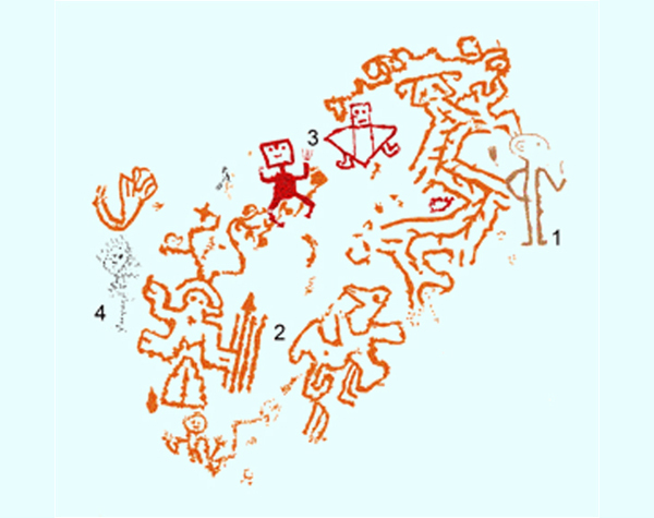 |
Figure 21. The four possible
phases of petroglyph production on Boulder CNG-020,
Cerro Negro, northern Peru.
Drawing © by Maarten van Hoek (2014). |
Acknowledgements
First of all I would like to express my gratitude
towards Daniel Seuart Castillo Benites, archaeologist from Trujillo, Peru, who
has generously helped me with information about Chicama rock art and especially
Cerro Negro and who also helped me pinpointing the exact location. I am also
grateful to Carol Patterson for sharing her personal photographs of the Santa
Rita petroglyph site with me. Of course I am, as ever, grateful to my wife
Elles for support in the field and at home.
Cerro Negro can only be reached by crossing private
land. Please make sure that you have permission to enter any private property.
We thank all the Chicama-locals who have helped us with information and those
who gave us permission to cross or visit their properties. Therefore I am also
indebted to Franco who kindly guided us to Cerro Negro in 2012.

—¿Preguntas,
comentarios? escriba a: rupestreweb@yahoogroups.com—
Cómo citar este artículo:
van Hoek, Maarten. A critical
analysis of the rock
art on boulder CNG-020, Cerro Negro, Chicama, La Libertad,
Perú.
En Rupestreweb, http://www.rupestreweb.info/cerronegro.html
2014
REFERENCIAS
Burgos Oliveros, H. B. et al. 2006. Estudio de Diagnóstico y Zonificación para el Tratamiento de la
Demarcación Territorial y Organización del Territorio de la Provincia Ascope.
Gobierno Regional La Libertad. Trujillo, Perú.
Castillo
Benites, D. S. 1993. Petroglifos de Alto Chicama. Suplemento Dominical, Diario La Industria: 22/08/93.
p7. Trujillo, Perú.
Castillo
Benites, D. S. 1994. Petroglifos de Pampas de Jagüey. Boletín
de Lima. Vol. XVI, N° 91-96, pp 27 - 30, Editorial Los Pinos, Lima, Perú.
Castillo
Benites, D. S. 2004. Petroglifos en Cerro Negro, Playa Cuculí,
Valle Chicama - Perú. Resumenes del Primer Simposio Nacional de Arte
Rupestre; p 24. In: Rainer Hostnig et al.; 2004. Resumenes. Primer Simposio Nacional de Arte Rupestre; Cusco, 2004.
Cusco, Perú.
Castillo Benites, D. S. 2006. Arte Rupestre en la Cuenca
del Río Chicama. Ediciones SIAN, Arqueología / 4. Trujillo, Perú.
Castillo
Benites, D. S. 2007. Petroglifos en Cerro Negro, jurisdicción de
Pampas de Jagüey, cuenca del Chicama - Perú. Actas del Primer Simposio nacional de arte rupestre; Cusco,
noviembre 2004; pp 69 - 81. Lima, Perú.
Castillo Benites, D. S. 2008a. Las Pinturas Rupestres del Río Seco de Santa Ana, Jurrisdicción de
San Benito, Cajamarca. Revista del Museo
de Arqueología, Antropología y Historía, No. 10, pp 239 - 248.
Castillo Benites, D. S. 2008b.
Una Aproximación a la definición de Estillos Rupestres en las Cuencas de los
Ríos Chicama, Moche y Virú, Region La Libertad, Perú. PowerPoint Presentation
presented at the III Simposio Nacional de Arte
Rupestre. Huaraz, Perú.
Disselhoff,
H. D. 1971a. Arte rupestre del Sur de Perú. Antike Welt; Zeitschrift für
Archäologie und Urgeschichte; 2. Jahrgang, Heft 1, pp 33 - 44. Zürich. Traducido de alemán por Rainer Bartels y Renata
Faron-Bartels.
Disselhoff,
H. D. 1971b. Südperuanischer Felsbilder. Antike
Welt; Zeitschrift für Archäologie
und Urgeschichte; 2. Jahrgang, Heft 1, pp 33 - 44. Zürich.
Hostnig, R. 2003. Arte rupestre del Perú. Inventario Nacional. CONCYTEC, Lima, Perú.
Hostnig, R.
et al.
2004. Resumenes. Primer Simposio
Nacional de Arte Rupestre; Cusco, 2004. Cusco, Perú.
Krickeberg, W. 1949. Felsplastik
und Felsbilder bei den Kulturvölkern Altamerikas mit besonderer
Berücksichtigung Mexicos. Palmen Verlag, Berlin.
Larco Hoyle, R. 1944. Cultura Salinar. Síntesis Monográfica. Buenos Aires.
Sociedad Geográfica Americana.
Linares
Málaga, Eloy 1978. Prehistory
and Petroglyphs in Southern Peru. In: Advances
in Andean Archaeology; pp 371 - 392. Editor: David L. Browman. Cambridge University
Press.
Linares
Málaga, E. 1999. Arte Rupestre en Sudamerica
Prehistoria. Universidad Nacional Mayor de San Marcos. Lima, Perú.
Núñez
Jiménez, A. 1986. Petroglifos del Perú.
Panorama mundial del arte rupestre. 2da. Ed. PNUD-UNESCO – Proyecto
Regional de Patrimonio Cultural y Desarrollo, La Habana.
Van Hoek, M. 2005. Biomorphs ‘playing a wind
instrument’ in Andean rock art. Rock Art
Research, Volume 22-1, pp 23 - 34. Melbourne, Australia.
Van Hoek,
M. 2007.
Petroglifos Chavinoides cerca de Tomabal, Valle de Virú, Perú. Boletín de
SIARB, Vol. 21, pp 76 - 88. La Paz, Bolivia.
Van Hoek, M. 2011. The Chavín
Controversy - Rock Art from the
Andean Formative period. Privately published (using the BLURB Creative Publishing
Service), Oisterwijk, The Netherlands.
Van Hoek, M. 2012a. Cerro Mulato: Rock Art of the Reque-Chancay Drainage, Peru.
Privately published (using the BLURB Creative Publishing Service), Oisterwijk, The Netherlands.
Van Hoek, M. 2012b. Rumimantam
Llaqllasaq Wirpuykita: The ‘Cycle of Life’ in the Rock Art of the Desert Andes.
Privately published (using the BLURB Creative Publishing Service), Oisterwijk, The Netherlands.
|