 Cerro
Pano: A violated and endangered rock art site in Southern Perú Cerro
Pano: A violated and endangered rock art site in Southern Perú
Maarten van Hoek rockart@home.nl
INTRODUCTION
To begin with, there is some confusion
about the name of this rock art site, which is located in the south of Peru (Departamento de Arequipa; Provincia de
Camaná). To explain this misunderstanding about the name, I will discuss the
major problem at Cerro Pano.
In brief, a recently constructed road (dotted
line in Figure 1) severely violated and still endangers this most interesting
rock art site, which in my opinion is a sacred place, like all other ancient
rock art sites in the Andes. According to the satellite photo in Google Earth,
this U-shaped stretch of the road - the coastal (dirt)road between Camaná and
Quilca - did not exist in 2004. Unfortunately, at a certain time between 2004
and probably 2006 the local authorities decided to divert this stretch of the coastal
road a little to the north. Apparently no-one insisted on an archaeological
survey of the area in advance and as
a destructive consequence the new stretch of the road now cuts right through
the southernmost tip of an important rock art site (Figure 2), destroying part
of the site and unfortunately still endangering major archaeological evidence.
Some of the rocks must have been displaced by the construction of the road and
are now lying at the foot of the hill slope. Another negative consequence is
that locals and tourists now have easy and uncontrolled access to the site.
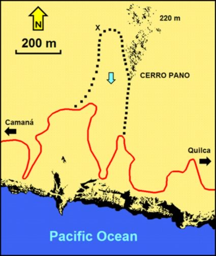
Figure
1. Location of the Cerro Pano petroglyph site (to the right of the blue arrow,
which indicates the course of a dry river) and the newly constructed road
(black dots). Drawing
by Maarten van Hoek, based on Google Earth.
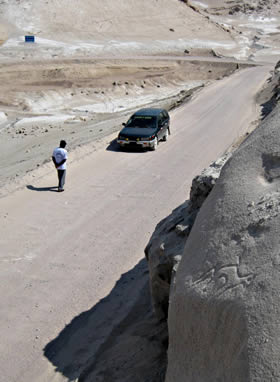
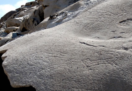
Figure
2. The rock art site of Cerro Pano, demonstrating its proximity to the road. In
the far distance the INC-sign is visible, while in the foreground the
petroglyphs of Panel 2B can be seen. Photograph by Maarten van Hoek.
Probably because of the construction of the
road the site was noted for the first time (around 2006) and since then the
site became more and more known to the public. The site was reported to me in
2006 when Augusto Cardona Rosas, Director of the Centro de Investigaciones Arqueológicas de Arequipa (CIARQ) based in the city of Arequipa, emailed
me a photo of one of the rock art panels (Panel 5A) as part of a campaign to
protect endangered rock art sites in Arequipa (like Culebrillas in the Vitór
drainage). In his email he referred to the site as ‘Quilca’. However, only the fact that the site is
located ‘on the road to Quilca’ seems
to have determined its name. Yet, the site is located exactly midway between
the town of Camaná (17 km west) and the village of Quilca (17 km east). Thus, the
site could equally be named Camaná, especially as the site is more easily
reached from Camaná. Even more confusing is the fact that the Asociación Peruana de Arte Rupestre (APAR)
refers to every (Peruvian? Andean?) rock with rock art as a ‘quilca’: quilca - término en lengua Quechua o Aymara que
designa el fenómeno del arte rupestre, principalmente pictogramas y
petroglifos; usado desde antes del surgimiento del Imperio Tahuantinsuyu (Inca)
en los Andes (APAR 2010). Therefore it is not strange to find other rock
art sites called Quilca, like for instance the site Quilca in La Libertad (Hostnig
2003: 210).
Later, several Peruvians uploaded photos of
the site onto the Internet (Drakoman 2008; Zevallos Vergara 2008; Yupanqui 2009; Zevallos 2010; Bullard 2011), but some referred to the site as: Petroglifos del Pescador - ‘petroglyphs
of the fisherman’. The only reason for this name
seems to be that the INC (Instituto
Nacional del Perú) has ‘decided’ that only fishermen could have lived in
this dry area and that thus these fishermen were responsible for the
petroglyphs. Consequently the INC erected a sign - named Pescador - a short distance NW of the site (X in Figure 1 and
visible in Figure 2). Because this alleged relationship is not at all certain,
I also reject the name Pescador. Interestingly,
not a single petroglyph at Cerro Pano unquestionably depicts a marine creature.
Only three ‘snakes’ petroglyphs might be marine ‘eels’. Yet, there is a definite link between Cerro Pano and the
Pacific Ocean as I will demonstrate further on.
Preparing an article
about the ‘trophy’ head petroglyphs of the Majes area for Rupestreweb (Van Hoek
2010), I described several rock art panels of the Cerro Pano site, using the
photographs made by Rainer Hostnig, a most productive Peruvian rock art
researcher. Because I did not agree with both the names Quilca (too far away and too confusing) or Pescador (too artificial and not at all related to the rock art), I
then decided to simply name the site after the hill it was located on: Cerro
Pano (source: Google Earth). To avoid confusion I will continue to do so.
Importantly, in
2011 a serious alarm was put on the Internet by Arturo Bullard (2011) who
argued that the unprotected site was very vulnerable to both natural (erosion)
and anthropic (humanly caused) damage. Because of his ‘alarm bell’, I decided to write
a descriptive paper about the site. Up to date (2011) the ‘only’ damage to the
site was erosion and the most unwanted construction of the road through this
sacred site. Yet, I fully agree with Arturo Bullard that this site merits full
and official protection.
SITE
DESCRIPTION
The Cerro Pano petroglyph site has a rather
unusual location. First of all, Cerro Pano is situated only 600 metres north of
the Pacific Ocean (Figure 1). Moreover, the area is extremely dry and often
very windy. It is impossible to walk or even move around the site without generating
clouds of extremely fine dust (polvo).
Despite the frequent sea mist, there is hardly any vegetation in the area
except for a few insignificant bushes on the valley floor and one or two low
cacti at the site. What is exceptional about the location is that - today - the
nearest fresh-water source, the mouth of the Quilca/Vitór River is about 17 km
to the east, while the mouth of the river Majes is even 20 km to the west. To
the west the site overlooks a dry river valley that runs from north to south (the
valley floor is about 62 m O.D.).
The site occupies the rather steep (average
30 degrees), west-facing slope of a low hill/ridge called Cerro Pano (the highest
point is found NW of the site; at about 220 m O.D.). The landscape is bleak.
The sands and the rocks have the same grey and white colour and only because of
their shadows the higher rocks stand out more clearly. This rocky area extends
from north to south for about 400 metres, but only the southernmost tip - an
area of some 35 m from north to south - comprises petroglyph rocks and unfortunately
this southern area has been damaged by the road. The decorated rocks are found
from 84 m O.D. at the southernmost tip of the petroglyph area to about 90 m
O.D., 35 m further north. The rocks at Cerro Pano probably represent a harder
band of stone that became undermined and scarred because of erosion (nowadays mainly
wind erosion and possibly much earlier erosion by running water) and as a
consequence there are some caves or rather, rock shelters. Some parts of the apparent
ceiling have collapsed. Several rocks are hollow or have large cavities and/or holes
in them. Importantly, a
rather thick refuse layer (basural) that
has accumulated in front of a rock shelter definitely contains sea-shell
material (and possibly layers of ash and other organic remains). This unquestionably
demonstrates that the site/rock shelter once was inhabited and that the ocean supplied (part of?) the food. Unfortunately,
this refuse layer has also (partially) been destroyed by the construction of
the road. This unwanted cross-section made by the road-construction shows that
the refuse layer extends from Rock 1 to Rock 18. Figure 3 shows a cross-section
of the refuse layer (numbered 1) in which sea-shells (in one case with
barnacles on it). Notice that the refuse layer actually consist of two rather
clearly separated layers; one (1a) with many organic remains and a layer (1b)
that has only very few organic remains (for instance the shell with barnacles).
Layer 1b could be indicative of an environmental change (the sediment in layer
1b has a different colour and texture), heralding the abandonment of the site.
This could have been a change in climate or a volcanic eruption. Layer 2
represents the ‘recent’ sand and dust accumulation on top of the refuse layer
with no visible organic remains (this should be checked scientifically). This
absence of organic remains implies in Layer 2 that the habitation site was at a
certain time abandoned. However, the site may still have afterwards been
visited by other people who manufactured the petroglyphs. Number 3 is the base
of Rock 2.
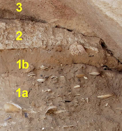
Figure
3. Detail of the refuse layer at the rock art site at Cerro Pano (for an explanation
see the text above). The yellow arrow in Figure 4 indicates the position of
this cross-section. Photograph by Rainer Hostnig (numbering by Maarten van
Hoek).
It was not always possible to distinguish
outcrop rock from boulders and for that reason I have numbered the rock art panels disregarding the type of stone.
In several cases the rocks are clearly isolated from each other, but in other
cases only a crack separates one rock from the other. Realising that the
labelling is somewhat subjective, I have numbered 18 rocks at Cerro Pano with a
total of 28 panels/areas with petroglyphs (Figure 4). The different Panels on one rock are only separated by
often faint natural features such as a shallow gully or a different slope. The
petroglyph rocks in Figure 4 show two different colours only to distinguish
them better from neighbouring panels. Likewise, the undecorated rocks show
varying grey-colouring: the darker the steeper the surface - the lighter the
more horizontal (please note that many undecorated
rocks have not been included in the site-plan). The lay-out of the site plan
and the 10 meter-grid only approximate the reality as I did not undertake a
scientific survey. All results are based on my own photographic record of the site (sometimes comparing my photos with
those of Rainer Hostnig) and on Google Earth. Therefore the following
description of the panels does not represent a scientific inventory. It must be emphasised that many images are
extremely faint or that the light was not always favourable during my survey and
therefore several petroglyphs could not be photographed properly. All
measurements in the descriptions are approximated. Also, most cupule-like
features have been ignored, unless they are (clearly part of or possibly) a
petroglyph.
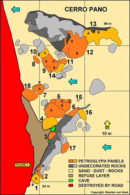
Figure
4. Plan of the Cerro Pano petroglyph site. Drawing by Maarten van Hoek.
Description of the panels
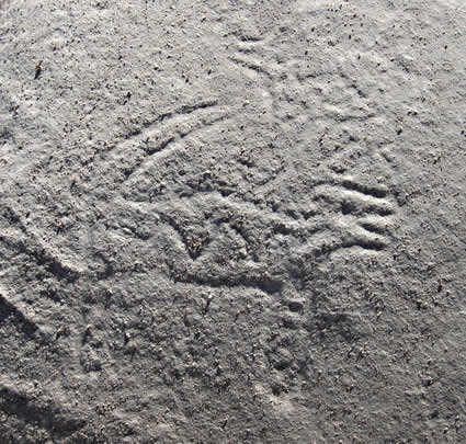
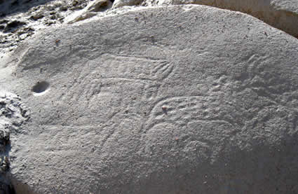
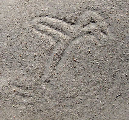
ROCK 1 - PANEL 1A: This is the
southernmost decorated rock, slightly sloping to the SW and heavily undermined
by the new road directly to its west. It is also one of the most interesting
petroglyph panels at Cerro Pano. The upper surface (Panel 1A) is decorated with
two rather deeply engraved serpent-shaped biomorphs (Figure 5). The smaller biomorph
- bend in a U-shape - is filled with numerous cupules, while the larger biomorph
(about 65 cm in length) has four curves and has been decorated with twelve ‘circles’,
ranging between 4 and 8 cm in diameter. However, as neither the head nor the
tail areas resemble those of real snakes, these biomorphs may well be (marine) eels
or even mythical creatures. Besides the two biomorphs this panel has three
groups of mainly curved lines that are so faint that it is impossible to judge
what these represent (spotted zoomorphs perhaps?).
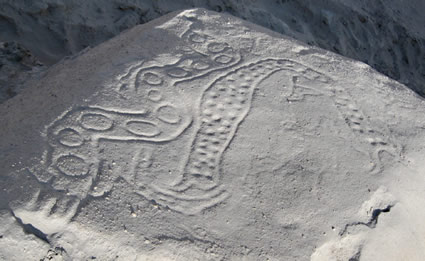
Figure
5. Cerro Pano - Panel 1A.
Photograph by Maarten van Hoek
ROCK 1 - PANEL
1B: This is the smaller, southern side of Rock 1, which
has one outlined and dotted quadruped petroglyph (about 20 cm in length) and
four groups of grooves, two of which may represent zoomorphs (one outlined; one
match-stick zoomorph). ROCK
2 - PANEL 2A:
Slightly higher and immediately to the north of Rock 1 is a long rock of which
the southern tip has a few petroglyphs. There are also petroglyphs on three other
areas of this rock further NE: Rocks 3, 6 and 16. Panel 2A - showing a distinct
slope to the SW - has an interesting outlined zoomorph petroglyph (about 25 cm
in length) filled with small cupules (Figure 6). The way this zoomorph has been
executed gives the impression that the animal has two heads. Immediately to the
left are two smaller, fully pecked zoomorphs that are confronting each other,
while possibly one or two pecked zoomorphs have been engraved at a lower level.
This panel continues into a natural hollow where a small circle has three
straight, downward pointing grooves and possibly a fourth groove which runs
upwards. This petroglyph may represent a ‘trophy’ head, although no eyes have
been included. I will return to the ‘trophy’ head matter in the discussion.
Figure
6. Cerro Pano - Panel 2A: Detail of the two-headed (?) zoomorph.
Photograph
by Maarten van Hoek.
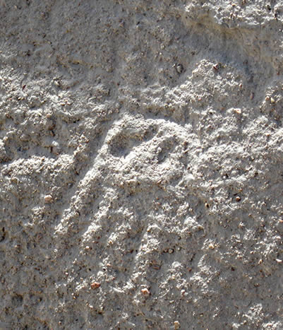
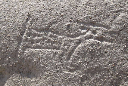
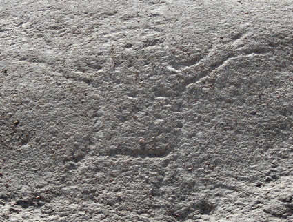
ROCK
2 - PANEL 2B:
Immediately to the north and on a slightly higher level is one clear outlined
zoomorph (see Figure 2) with only one cupule for an eye (looking south). Immediately
to its north are - much fainter - another outlined zoomorph (smaller and
looking north) and a short zigzag (?).
ROCK
3: This steeply west facing rock (part of the same
rock as Rocks 2, 6 and 16) curiously overhangs the entrance to a small cave (in
which I could not find any rock art) in front of which is the thick layer of
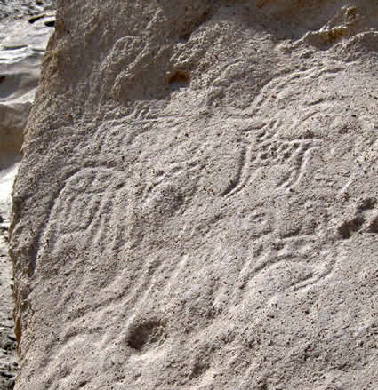
refuse (see Figure 3). Panel 3 features one large, outlined and spotted
zoomorph with a smaller, outlined and spotted ‘feline’ petroglyph (maximum
length is about 27 cm) on its back (Figure 7). To the north (left) are at least
two very faint and small, outlined zoomorphs and possibly more faint lines. Further
north on the panel may be an isolated circle. To the south (right) the head of
the largest zoomorph touches a petroglyph comprising a central cupule
surrounded by three concentric circles from which two, possibly three U-shaped
appendages emerge (at the 12 - 3 and 6 o’clock positions). The upper U-shape
encloses two cupules that may represent eyes; the whole configuration possibly
representing an anthropomorph.
Figure
7. Cerro Pano - Rock 3: Detail.
Photograph by Maarten van Hoek.
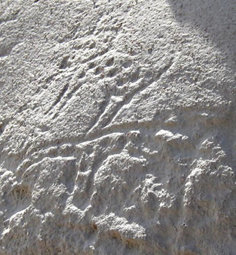
ROCK
4: This slab of stone probably represents part of a
collapsed ceiling. It rough surface steeply slopes to the west and has at least
eight outlined ‘zoomorphs’, two or three of which have internal cupules. All
the ‘zoomorphs’ are faint and prove to be rather poorly executed and some may
represent something entirely different. Most interesting is a small, inverted
‘trophy’ head at the centre of the panel (Figure 8). It comprises a small
circle (9 cm in diameter) with five (possibly six) parallel, downward pointing,
parallel grooves and two cupules for eyes. Directly above the head is a pattern
of lines, probably forming three concatenated rectangles. It may be connected
to the ‘trophy’ head.
Figure
8. Cerro Pano - Rock 4: Detail.
Photograph by Maarten van Hoek.
ROCK
5 - PANEL 5A:
Rock 5 is the most interesting stone of Cerro Pano. Not only it has the biggest
collection of petroglyphs; several are most intriguing. Also this large slab possibly
once formed the ceiling of a large cave, but most likely (judging by the
positions of the petroglyphs) the images were made (long) after the collapse.
There are many undulating surfaces on this high rock but for matters of
convenience four panels will be distinguished. Panel 5A is the most profusely
decorated panel which faces west. Most impressive on this panel are (Figure 9) a
vertically orientated snake-like biomorph filled with a row of small cupules
and two circles for eyes, and a deeply engraved, inverted ‘trophy’ head (9 cm
across) with eight parallel grooves running downwards while two grooves from
the top of the head are attached to a horizontal groove. Two large cupules
represent the eyes. There are many other petroglyphs on this panel that often
are hard to distinguish as some are faint and obscured by the rough surface,
while others are superimposed by other images and grooves. There is a group of
parallel zigzag grooves, several single zigzags and many grooves; at least twelve
(dotted) zoomorphs (Figure 10), a large snake-like and U-shaped biomorph, and a
bird.
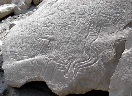
Figure
9. Cerro Pano - Panel 5A: The ‘trophy’ head; the ‘snake’ and (to its upper left)
a ‘bird’ petroglyph. Photograph by Maarten van Hoek.
Figure
10. Cerro Pano - Panel 5A: Two of the dotted zoomorphs.
Photograph
by Maarten van Hoek.
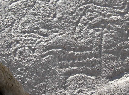
ROCK
5 - PANEL 5B:
A natural gully separates (lower) Panel 5A from (upper) Panel 5B. The steeply
west sloping Panel 5B has three (dotted) zoomorphs, a possible ‘snake’ or
serpentine groove and some indefinite markings.
ROCK
5 - PANEL 5C:
Panel 5C is the small, horizontal upper panel of this high rock. It features
only one (dotted?) zoomorph and a faint oval. Both are much weathered and
eroded.

Figure
11. Cerro Pano - Panel 5C.
Photograph by Maarten van Hoek.
ROCK
5 - PANEL 5D:
The steeply NW sloping Panel 5D has an interesting collection of images. Only a
curve separates Panel 5D from Panel 5B. Near the curve is a group of petroglyphs
(Figure 12). First of all we see an inverted ‘trophy’ head (10 cm across) with
seven parallel grooves running downwards. A single groove emerges from the top
of the head and is connected to a horizontal groove. The ‘trophy’ head has two
small cupules for eyes. Hovering over this horizontal groove is a strange
biomorph (?) possibly comprising a vertically oriented ‘bird’ crossed by a
curved ‘snake’. Hovering above this hybrid are the outlines of a possible small
bird. To the right of the hybrid is a faint, outlined zoomorph that almost
touches a zoomorph on Panel 5B. To the right of the ‘trophy’ head is an
outlined, spotted zoomorph.
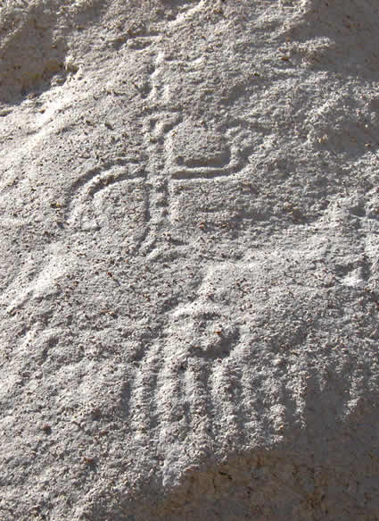
Figure 12. Cerro
Pano - Panel 5D: The part near the curve.
Photograph by Maarten van Hoek.
To the north of this first group is a second
group (Figure 13). Most significant is another ‘trophy’ head (19 cm across) very
near the edge of the panel. It has six downward running grooves and two cupules
and a short groove as facial features. The ‘hair’ seems to be intermingled with
an outlined zoomorph. Surrounding the head are at least nine zoomorphs (at
least five are spotted) and a strange feature with ‘eyes’. Below this group is
a complex pattern of grooves (the lower part comprising four parallel grooves,
each ending in a cupule) and a very faint zoomorph. Between this latter
zoomorph and the first group are several extremely faint grooves and/or images.
Figure
13. Cerro Pano - Panel 5D: Detail of the group near the edge.
Photograph
by Maarten van Hoek.
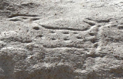
ROCK
6: This is the NW end of the same rock on which the
petroglyphs of Rocks 2, 3 and also 16 are found. On its almost vertical NW
facing surface is one petroglyph (Figure 14). It is rather crudely executed (in
different fashion than the other petroglyphs at Cerro Pano) and might represent an (unfinished?,
armless?) anthropomorph.
Figure
14. Cerro Pano - Rock 6.
Photograph by Maarten van Hoek.
ROCK
7 - PANEL 7A:
This rock has petroglyphs on its slightly sloping and undulating upper surface.
Most significant is a rather distinct zoomorph with dotted legs and a zigzag in
its body. It has an open mouth and a long tail above its back. Hovering above
its back is a second spotted zoomorph (bird?), much smaller this time (Figure
15). To the SW of the larger zoomorph are a zigzag and two outlined and
possibly spotted zoomorphs. Further SW still is one ‘snake’ petroglyph and an
outlined zoomorph.
Figure
15. Cerro Pano - Panel 7A: Detail. Notice the difference in visibility between
the two zoomorphs. Photograph by Maarten van Hoek.
ROCK
7 - PANEL 7B:
Rock 7 is hollow and the upper edge of the rim above the opening has two very
faintly visible petroglyphs of biomorphs. One probably represents a ‘snake’;
the other is also elongated but is of uncertain character.
ROCK
8: This small rock lying in front of Rock 10 has a
slope to the WNW. It has the very faint remains of a biomorph; possibly a
(spotted) quadruped.
ROCK
9 - PANEL 9A:
Rock 9 actually forms the largest part of a long stone, apparently broken into
four sections. Two sections bear petroglyphs (Rocks 9 and 10). Most remarkable
on this panel is a large zoomorph (88 cm from head to tail), which probably depicts
a ‘feline’ (Figure 16). The body and tail are spotted, but the legs have
horizontal bars. The head is rather strangely executed; possibly in ‘twisted
perspective’. Near this ‘feline’ are at least four smaller, outlined zoomorphs
(one in a strange vertical position), the unfinished outline of a fifth
zoomorph and a vertically orientated zigzag.
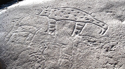
Figure
16. Cerro Pano - Panel 9A: Detail.
Photograph by Maarten van Hoek.
ROCK
9 - PANEL 9B:
This is the extreme SE end of Rock 9. Near the SE corner is one outlined and
spotted quadruped, while a long zigzag of 11-turns runs parallel to the rock’s SE
edge.
ROCK
9 - PANEL 9C:
The NW sloping upper surface of Rock 9 shows (when not covered by dust) two
simple, outlined zoomorphs that are differently orientated (Figure 17).
Figure
17. Cerro Pano - Panel 9C.
Photograph by Maarten van Hoek.
ROCK
10 - PANEL 10A:
Rock 10 is a smaller section of the same long and apparently broken stone. On
the upper Panel 10A (Figure 18) are six zoomorphs (at least two are spotted and
two may have internal decoration; possibly serpentine grooves) probably
representing ‘felines’ and/or quadrupeds (camelids?). The largest zoomorph
measures about 26 across. Two zoomorphs are rather indistinct. There is one
conspicuous cupule-like depression. It might be anthropic or humanly enhanced.
Figure
18. Cerro Pano - Panel 10A.
Photograph by Maarten van Hoek.
ROCK
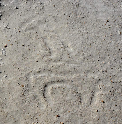
10 - PANEL 10B:
The lower Panel B actually is a continuation of Panel A but it slopes more steeply
to the WSW. On this panel is one spotted quadruped (22 cm across) (Figure 19).
Figure
19. Cerro Pano - Panel 10B.
Photograph by Maarten van Hoek.
ROCK
11: Just NE of Rock 9 is a higher rock (its south
part covered by Rock 14) that rather steeply slopes to the west. It has the
faint remains of one spotted zoomorph, but the species is uncertain (Figure 20).
Some grooves on this west facing panel may be anthropic as well.
Figure
20. Cerro Pano - Rock 11.
Photograph by Maarten van Hoek.
ROCK
12 - PANEL 12A:
Just above a large natural cavity in an enormously long rocky ridge is a dispersed
group of at least eight outlined zoomorphs (Figure 21). Two of these probably
represent (spotted) ‘felines’, although the layout of some images is rather
faint and uncertain. Higher up and near the north edge is a fine petroglyph of
a small, weathered ‘bird’ (Figure 22) and some very faint grooves (zoomorphs?).
The ‘bird’ is executed in profile and has a short ‘tear’ from the eye.
Figure
21. Cerro Pano - Panel 12A: Detail of some of the zoomorphs.
Photograph
by Maarten van Hoek
Figure
22. Cerro Pano - Panel 12A: Detail of the ‘bird’.
Photograph by Maarten van Hoek.
ROCK
12 - PANEL 12B:
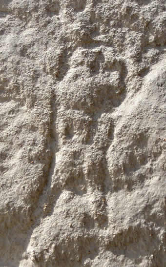
Near the south end of this smooth surface is a faint, outlined anthropomorphous
figure, frontally depicted, with only two small cupules for eyes. It has two raised
arms, while the legs are hardly visible because of the rough surface of the
rock (Figure 23).
Figure
23. Cerro Pano - Panel 12B.
Photograph by Maarten van Hoek.
ROCK
13 - PANEL 13A:
Scattered over the lower part of this large smooth rock (part of the same
enormous ridge) are three (spotted) zoomorphs (Figure 24). There might be a
fourth petroglyph of a zoomorph that has almost weathered off completely.
Figure
24. Cerro Pano - Panel 13A.
Photograph by Maarten van Hoek.
ROCK
13 - PANEL 13B:
East of the group on Panel 13A and slightly higher on the same ridge are three
faint, outlined zoomorphs, the uppermost example with at least two circles as
body decoration. There are faint (anthropic?) grooves in between those three
zoomorphs.
ROCK
14: This rock partially overlies Rock 11. On the very
steep, west facing surface are at least two rather indistinct petroglyphs of zoomorphs.
Both may be spotted. The southernmost example probably is a ‘feline’, while the
other is possibly a ‘camelid’.
Figure
25. Cerro Pano - Rock 14: The ‘camelid’ is visible on the left; the ‘feline’ is
(hardly) visible on the right. Photograph by Maarten van Hoek.
ROCK
15: This is a very small rock (often covered by
sand and dust) lying between Rock 5 and Rock 6. It may have been broken from
another rock. It has the remains of only one outlined and possibly spotted
zoomorph (Figure 26). As it seems to be incomplete, the species depicted is
uncertain.
Figure
26. Cerro Pano - Rock 15.
Photograph by Maarten van Hoek.
ROCK
16: This panel is part of the horizontal upper
surface of Rocks 2, 3 and 6. It has the very faint remains of one outlined
zoomorph and one possible oval groove.
ROCK
17: An almost horizontal stone has the (unfinished?)
remains of what probably has been intended to form a spotted zoomorph (Figure
27). It may even represent the head only.
Figure
27. Cerro Pano Rock - 17.
Photograph by Maarten van Hoek.
ROCK
18: Almost touching Rock 7 is a rock that almost
overhangs the road. On its undulating upper surface are the very faint remains
of probably a (spotted?) zoomorph.
Although my photographic record covers all
panels mentioned in this paper, some petroglyphs only showed up very faintly on
the photo and are too faint to be included in this paper. It also proved to be
impossible to photograph every panel properly because of the sometimes unfavourable
position of the sun. However, most panels do show up perfectly during the
morning. Some panels are better inspected around noon and a few require another
position of the sun to show up (sunset or sunrise).
Cultural context
The petroglyphs at Cerro Pano prove to have
much in common with the imagery of the central Majes Valley further north (48
km NNE) and may be compared with the rock art repertoire of sites like Toro
Muerto, Alto de Pitis, La Laja and La Barranca. Despite claims that (some of)
the ‘Majes’ petroglyphs are of Wari origin, it is safe to accept that the
great majority of the ‘Majes’ images - and possibly all the Cerro Pano petroglyphs - belong to the Chuquibamba Culture.
Decisive in this respect are the zigzags, the spotted quadrupeds (often
‘howling’ and sometimes showing internal zigzags like images at Toro Muerto) and
the ‘felines’. Even the few representations of ‘birds’ reflect the influence of
the Chuquibamba Culture, especially the ‘tear’ from the eye of the ‘bird’ in
Panel 12A. ‘Tears’ are a hallmark of many images at Toro Muerto, La Laja and
Alto de Pitis. Also the ‘snakes’ or ‘eels’ on Panel 1A and 5A have a certain ‘Toro
Muerto’ feel to them. Also, as far as I can judge, Cerro Pano was ‘only’ a local religious-habitation centre, situated
far from major strategic key areas and therefore of no importance to the Wari.
Also the occurrence of ‘trophy’ heads links
Cerro Pano with the Chuquibamba Culture. In an earlier article for Rupestreweb
(Van Hoek 2010) I stated that three ‘trophy’ heads had been recorded at Cerro
Pano. My survey of the site revealed two more examples (one on Panel 2A, and
another on Panel 4), bringing the total at Cerro Pano to five examples, while -
together with two still unpublished examples of ‘trophy’ heads at Toro Muerto
and Alto de Pitis - the grand total for the ‘Majes’ area is now 40 ‘trophy’
heads.
Recommendations
First of all, a full scientific survey of Cerro Pano is essential and should be carried
out as soon as possible by professional archaeologists. This survey should
record all relevant data and should provide a full scientific inventory of the
petroglyphs (site plan, photos, scale drawings and an explanatory text of all
panels etc) as well as a survey of all other archaeological remains, especially
of the refuse material.
Secondly, the site should get an official
status and should be explicitly and officially protected by Peruvian law. It is
also strongly recommended to take all measurements necessary to protect the
site from further destruction. The severely damaged section (west of Rocks 1 to
18) should be secured and the road should be diverted to the west of this
section, or better still, the whole
U-turn section of the new road should
be closed completely, re-using the old section of the road about 200 metres
south of the site (see Figure 1).
Thirdly, I strongly recommend a full scientific
analysis of the refuse layer in front of the
rock shelter. This analysis should also involve a full RadioCabon dating of all
layers so that the time of occupation and abandonment of the rock shelter can
be established. However, the refuse layer and
the petroglyphs need not necessarily be related to each other. It may prove
that the occupation of the rock shelter is of another date and that the
inhabitants were not the manufacturers of the petroglyphs. In order to better
understand this possible relation, I moreover suggest to examine the larger rock
shelter that is situated only 20 m north of Rocks 12 and 13 (not shown on the
plan of Figure 1), especially to see if it also has a refuse layer. The
entrance of the shelter and the area in front of it are now covered with sand
and dust, concealing archaeological remains. If this large shelter also has a real refuse layer (and it probably has, as a few sea
shells protrude through the sand and dust), it should be analysed as
well and the results should be compared with the findings of the analysis of
the refuse material from the area in front of Rock 3. A matching date for both
sites might imply that the
petroglyphs are not contemporary as
the large cave and the rock surfaces surrounding it have no petroglyphs (as far
as I have examined).
Last but not least, I suggest that the
whole area surrounding the site, especially the part crossed (and partially
destroyed) by the new road, should be scientifically surveyed and inventoried. Also
the rocky areas immediately north of the site and other areas further NNW should
be examined as they may prove to have petroglyphs or may yield other
archaeological remains. Furthermore, the small valley floor west of the site
may have ancient remains. There are (circular) structures on the valley floor,
visible from the rock art site, but their nature could not be established by me.
I sincerely hope
that the heartfelt wish of Arturo Bullard will soon be realised: Los Petroglifos de Quilca merecen ser protegidos (Bullard 2011).
ACKNOWLEDGEMENTS
I am grateful to Rainer Hostnig who initially
provided me with his complete private collection of his photos of Cerro Pano. I
have used one of his photos (Figure 3) as in his photo the relevant details showed
up better. I also thank my wife Elles for her assistance during the survey. All
photos in this paper have been digitally enhanced by me, but not changed.

—¿Preguntas,
comentarios? escriba a: rupestreweb@yahoogroups.com—
Cómo
citar este artículo:
van Hoek, Maarten. Cerro Pano: A violated and endangered rock art site in Southern Perú
En Rupestreweb, http://www.rupestreweb.info/cerropano.html
2011
BIBLIOGRAPHY
Apar.
2010. Glosario de Arte Rupestre. In: http://sites.google.com/site/aparperu/home/glosario-glossary
Bullard, A. 2011. Petroglifos de Quilca, Joya
Abandonada en la Costa Arequipeña. In: http://arturobullard.blogspot.com/2011/03/petroglifos-de-quilca-joya-abandonada.html
Drakoman. 2008. In: http://www.decamana.com/fotos-camana/petroglifos.html
Hostnig, R. 2003. Arte rupestre del Perú. Inventario
Nacional. CONCYTEC, Lima.
Van Hoek, M. 2010. ‘Trophy’ heads in the rock art of
the Majes Valley, Perú: exploring their possible origin. In: RupestreWeb: http://www.rupestreweb.info/trophy.html
Yupanqui, L. 2009. Petroglifos de Quilca, Arequipa. In: http://www.flickr.com/photos/luisyupanqui/3211084449/in/set-72157623995429278
Zevallos Vergara, M. 2008. Petroglifos de Quilca. In: http://camanahermosa.blogspot.com/2008_06_01_archive.html
Zevallos, M. 2010. Petroglifos. In: http://www.panoramio.com/user/582373
[Rupestreweb Inicio] [Introducción] [Artículos]
[Noticias] [Mapa] [Investigadores] [Publique] |