A new geoglyph (?) in Nepeña, Northern Peru
Un nuevo geoglifo (?) en Nepeña, norte del Perú
The coastal deserts west of the Andes are
famous for the numerous prehistoric geoglyphs; large scale figurative and
abstract art made by arranging small stones and earth. Best known are the
geoglyphs in the Iquique-Arica area in northern Chile and in the Nazca-Palpa
area of southern Peru. Further north along the Pacific Coast geoglyphs are
rather rare. Still, also in the coastal deserts of northern Peru geoglyphs have
been recorded. The best known examples are found (from north to south) in the
Zaña Valley: two large Formative Period geoglyphs near Oyutun; in the Moche
Valley: the geoglyphs of Santa Domingo; in the Virú Valley: the linear
geoglyphs at Queneto; in the Santa Valley: a large collection of geoglyphs near
Vinzos; between the Sechín and Casma Valleys: the geoglyphs of Pampa Colorado; and
in the Huarmey Valley: the geoglyphs of Cerro Copa de Sombrero. However, as far
as I could check, no ancient geoglyphs have ever been recorded in the Nepeña
Valley, which is surprising as Nepeña, located between Santa and Sechín,
definitely was important from the Formative Period to Inca times.
Los desiertos costeros al oeste de
los Andes son famosos por los numerosos geoglifos prehistóricos; arte
figurativo y abstracto de gran escala hecho arreglando tierra y piedras pequeñas.
Más conocidos son los geoglifos en la zona de Iquique-Arica en el norte de
Chile y en la zona de Nazca-Palpa en el sur del Perú. Más hacia al norte en la
costa del Pacífico los geoglifos son algo raros. Aún así, también en los
desiertos costeros del norte del Perú geoglifos se han registrado. Los ejemplos
más conocidos se encuentran (de norte a sur) en el valle Zaña: dos grandes
geoglifos del Período Formativo cerca de Oyutun; en el valle de Moche: los
geoglifos de Santo Domingo; en el valle de Virú: geoglifos lineales de Queneto;
en el valle de Santa: una gran colección de geoglifos cerca de Vinzos; entre
los valles de Casma y Sechín: los geoglifos de Pampa Colorado; y en el valle de
Huarmey: los geoglifos de Cerro Copa de Sombrero. Sin embargo, en cuanto podría
comprobarlo, no antiguos geoglifos jamás se han registrado en el valle de
Nepeña, que es sorprendente como Nepeña, ubicado entre Santa y Sechín,
definitivamente era importante desde el período Formativo a los tiempos de los
Incas.
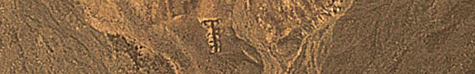
Yet, one feature in Nepeña may represent an
ancient geoglyph. Clearly visible with Google Earth is a definitely anthropic
figure located on the lower part of the slope of a low hillock in the Nepeña
Valley (Figure 1). The abstract (?) figure measures about 18 m in length, 5.5 m
in width at the lower end and 11 metres in width at the top. The lower end is
at 232 m O.D., while the upper end has an altitude of 235 m (all measurements
and altitudes are based on Google Earth). The site overlooks the confluence of
three ‘quebradas’. There are no
modern roads or tracks or paths in its direct vicinity, which also argues in
favour of authenticity. In all directions the mountainous landscape is
untouched. Therefore it is very likely that the feature represents an ancient
geoglyph composed of the anthropic accumulation of stones forming low walls.
The height of those walls is unknown, but they probably will not exceed 50 cm. Most likely they are much lower.
Sin embargo, una estructura en Nepeña
puede representar un geoglifo antiguo. Claramente visible con Google Earth es
una figura sin duda antrópica situada en la parte inferior de la ladera de una
colina baja en el valle de Nepeña (Figura 1). El figura abstracta (?) medidas
cerca de 18 m de longitud, 5,5 m de ancho en el extremo inferior y 11 metros de
ancho en la parte superior. El extremo inferior está en 232 m, mientras que el
extremo superior tiene una altura de 235 m (todas las medidas y alturas están
basados en Google Earth). El sitio ofrece vistas a la confluencia de tres quebradas.
No existen modernas carreteras o pistas o senderos en sus inmediaciones, que
también defiende la autenticidad. En todos los lados, el paisaje montañoso está
intacto. Por lo tanto es muy probable que la estructura representa un geoglifo
antigua compuesta por la acumulación de piedras que forman las muros bajas
antrópicas. La altura de los muros se desconoce, pero probablemente no excederá
50 cm. Probablemente son mucho más
bajos.
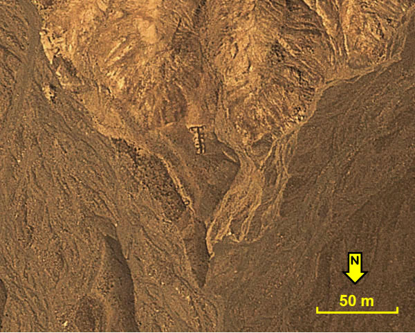 |
Figure 1. An ancient (?) ‘geoglyph’ in the Nepeña
Valley of northern Peru. Photograph © by Google Earth.
Figura 1. Un antiguo (?) ‘geoglifo’ en el valle de Nepeña, norte
del Perú. Foto © Google Earth.
|
The ‘geoglyph’ (Figure 2) is formed by a
south-north running pivotal wall with four short extensions emerging from the
pivotal wall running to the west and five short extensions running to the east.
The four westward pointing extensions are all curved to the south. The eastward
pointing extensions are either straight or curve slightly to the south, while
the lowermost extension curves northwards. The top of the ‘geoglyph’ seems to
be formed by an east-west running wall; each end having two very short
northwards or NW running walls. When viewed from the north, especially these
short walls give the top part of the ‘geoglyph’ the impression of a quadruped.
El ‘geoglifo’ (Figura 2) está formado
por un muro central alineado de norte a sur con cuatro extensiones cortas
emergentes del muro central y cinco extensiones cortas corriendo hacia el este.
Todos las cuatro extensiones apuntando hacia el oeste se curvan hacia el sur.
Las extensiones apuntando hacia el este están recta o curvada ligeramente hacia
el sur, mientras la extensión más inferior se curva hacia el norte. La parte superior
del ‘geoglifo’ parece estar formado por un muro corriendo este-oeste; cada
extremo tiene dos paredes muy corto corriendo hacia el norte o NO. Al ser
observadas desde el norte, especialmente estos cortos muros dan la parte
superior de la ‘geoglifo’ la impresión de un cuadrúpedo.
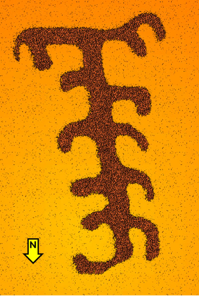 |
Figure 2. Reconstruction of an ancient (?)
‘geoglyph’ in the Nepeña Valley of northern Peru.
Drawing © by Maarten van
Hoek, based on Google Earth.
Figura 2. Reconstrucción de un
antiguo (?) 'geoglifo' en el valle de Nepeña, norte del Perú.
Dibujo © por
Maarten van Hoek, basado en Google Earth.
|
No monumental complexes are found near the
‘geoglyph’. There are faint traces of low ruins; mainly (groups of) circular or
rectangular constructions that may have been (temporary?) habitation sites.
Importantly, the ‘geoglyph’ is found in the neighbourhood of an ancient road
(10 m in width); one of many in the pampas bordering the Nepeña Valley. This
road abruptly ends and there are no visible traces that run east or west of the
low hill with the ‘geoglyph’. It may be possible to see the ‘geoglyph’ from the
abrupt ending of the ancient road. This road, coming from the valley, does not
seem to lead anywhere and also does not seem to connect with any other
prehistoric road in the area. It often occurs that those ancient roads end
without a comprehensible reason. As such ancient roads are known from the
Formative Period (Cupisnique roads) to the Late Horizon (Inca roads), this
specific ancient road can be of any date. Also the date of the ‘geoglyph’ is
unknown. Only further research will possibly solve this issue.
Complejos monumentales no se
encuentran cerca del ‘geoglifo’. Hay débiles rastros de ruinas bajos;
principalmente (grupos de) estructuras circulares
o rectangulares que pueden haber sido sitios de habitación (temporal?). Lo
importante es que el ‘geoglifo’ se encuentra en la proximidad de una carretera
antigua (10 m de ancho); uno de los muchos en las pampas que bordean el valle
de Nepeña. Este camino termina abruptamente y no no hay rastros visibles que
corren hacia el este o al oeste de la colina baja con el ‘geoglifo’. Quizas es
posible observar el ‘geoglifo’ desde el final abrupto de la antigua carretera. Esta
carretera, procedentes del valle, parece no llevar a ninguna parte y tampoco
parece conectarse con cualquier otro camino prehistórico en la zona. Ocurre a
menudo que los antiguos caminos terminan sin una razón comprensible. Como tal
antiguos caminos son conocidos desde el período Formativo (caminos Cupisnique)
hasta el Horizonte Tardío (caminos Inca), esta antigua carretera específica
puede ser de cualquier fecha. También se desconoce la fecha del ‘geoglifo’. Más
investigación posiblemente va a resolver este problema.

—¿Preguntas,
comentarios? escriba a: rupestreweb@yahoogroups.com—
Cómo citar este artículo:
van Hoek, Maarten. A new geoglyph (?) in Nepeña, Northern Peru.
En Rupestreweb, http://www.rupestreweb.info/geoglyphnepena.html
2015
|