An analisis of the evaluation and diagnostics to environmental impacts in rock art stations of Guaniguanico Montain Range, Cuba
Racso Fernández Ortega racsof@sangeronimo.ohc.cu
Dany Morales Valdés
Dialvys Rodríguez Hernández
Victorio Cué Villate
Hilario Carmenate Rodríguez
Cuban Group of Rock Art Researches (GCIAR)
Cuban Institute of Anthropology (ICAN)
Artículo publicado originalmente en Memorias de la Conferencia Internacional de Arte Rupestre 2012, por el 25 aniversario de Indira Gandhi, National Center for the Arts, Nueva Delhí, India.
RESUMEN
En los marcos del proyecto de evaluación y diagnóstico del patrimonio arqueológico y sociocultural de Cuba, desarrollado por un colectivo del Departamento de Arqueología del Instituto Cubano de Antropología (ICAN), se efectuó una expedición de conjunto con miembros del Grupo Cubano de Investigaciones del Arte Rupestre (GCIAR) para evaluar los impactos medioambientales que están deteriorando al dibujo rupestre de esta provincia. En este sentido de manera aleatoria de las 37 estaciones que posee la región se seleccionaron 17, lo que representa el 45,9%), para conocer el estado de conservación de las mismas, mediante la aplicación del método de evaluación y diagnóstico del patrimonio arqueológico que aplica nuestra institución. La referida metodología permite clasificar las acciones en naturales y antrópicas para la mejor búsqueda de soluciones que permitan eliminarlas o la ejecución de acciones paliativas para frenar, en alguna medida, su deterioro. Para ello en el trabajo se definen, enumeran y caracterizan las acciones y los impactos que más perjudican el estado de conservación de este importante patrimonio.
Palabras claves: Evaluación,
diagnóstico, impacto medioambiental, dibujo rupestre, Cuba.
ABSTRACT
In the marks of the research project Evaluation and diagnosis of the archaeological and sociocultural heritage of Cuba, developed by a group of the Department of Archaeology of the Cuban Institute of Anthropology (ICAN), an expedition was made joined to members of the Cuban Group of Rock Art Researches (GCIAR) to evaluate the environmental impacts that are affecting the rock drawings of Pinar del Río province. 15 stations of 38 located in that area were randomly selected to apply the evaluation and diagnosis methodology of environmental impacts that is used by ICAN. The applied method allows classifying the natural and anthropic actions for the best search of solutions to eliminate the damage, or the practice of palliative actions to stop, in some way, its deterioration. So, the actions and impacts that affect in a deeper way the state of conservation of this Cuban important heritage are defined, enumerated and characterized in this paper.
Keywords: Evaluation, diagnosis, environmental impact, Rock Art, Cuba.
INTRODUCCIÓN
The problem of
the protection and conservation of rock art is a concern to universal scale,
linked to the real fact that annually a great number of stations get lost
because of diverse factors, but mainly for the uncontrollable and negative
actions of humans. Three examples in our country are the rock art stations of
Cueva Mesa and Cueva La Jarra in the municipalities of Viñales, Pinar del Río,
and San Cristóbal, in Artemisa Province, respectively, or the Cueva de los
Golondrinos in Baracoa, Guantánamo Province. These stations were victims of
mechanisms of adaptation because of their "setting in value" or
habilitation of its archaeological places with different purposes and
strategies, without a true impact study that analysed the consequences of those
activities on their paintings. The harmful results on the rock art began to
occur and as a consequence they are getting deteriorated sooner than if the
natural processes occurred.
As it is very well-known, the pictographs and petroglyphs are products
of the social conscience, and they regrettably remain joined to the natural
aging of their supports, pigments and agglutinants, becoming themselves along
time in a truly vulnerable and fragile resource.
Even so, this ancient heritage has remained for us –even, in many
occasions, with an antiquity of several thousands of years–, what shows
evidence of its good invoice, resistance and adaptation to the environmental
changes that have taken place from its creation. That is the reason why in some
occasions the opinion emitted by some officials, that regrettably "the
development" cannot depend on to a manifestation that sooner or later will
disappear, it is not well considerate and accepted (1).
1. Nowadays, a non-sustainable development that doesn't take advantage of
the particularities of the surrounding ecosystem of each selected area, is unthinkable.
The value of the historical-cultural heritage represents an important source of
power to the national identity and the residents could be transformed into main
actors for its protection and conservation.
|
However, the Cuban experience demonstrates that the anthropic
affectation, either voluntary or not, is the biggest source of irreversible
aggressions suffered by this manifestation (Fernández and González 2001). This
bases the urgent necessity to protect the Cuban rock art registrations with
effectiveness, in their environmental context, what is at least, tried to be
analysed in this work related with the rock art stations of Guaniguanico Mountain
Range, in the western side of Cuba.
With this objective, in the Cuban Institute of Anthropology (ICAN),
during the years 2006 to 2008, the research project PNAP/0409 "Evaluation
and Diagnosis of the Archaeological and Sociocultural Patrimony of Cuba"
was developed by a team of the Department of Archaeology, due to the quick
process of economic and social development occurred during the last decades,
that has caused the affectation and/or threat to a sensitive number of
archaeological places along the country.
Because of that, in June of 2007 and with
members of the Cuban Group of Rock Art Researches, it was determined to carry
out a study based on the approach accepted by the international experience,
that the bad anthropic manipulation of the ecosystems settled around rock art
stations, is the fundamental cause that provokes secondary effects such as, the
presence of microorganisms, of plants and opportunists zoological species that
damage this millennial irreversible heritage.
THE AREA OBJECT OF STUDY
In the western side of the Cuban island, two mountainous elevations are
located, extended along an important area of Pinar del Río and Artemisa
Provinces. This geographical accident is a mountain range well-known with the
aboriginal name of Guaniguanico; it is projected almost parallel to both north
and south costs, and it has several physical-geographical divisions differed to
each other by its peculiar natural characteristics. The superficial extension
of Guaniguanico Mountain Range is around 3 102 km2 and it spreads from West to
East for about 150 kms approximately from the Cerros de Guane until the
elevations located in Cayajabos, in the central part of the current Artemisa.
In the north and south sectors, surrounding the mountain range, the Llanura Ondulada and the Llanura Deltaica are located,
-extended around 10 and 20 km of the coast, and expanded until 20 and 30 km of
the sea, respectively.
The mountain range “Sierra de los Órganos” is located in the western
part of Guaniguanico, and is very old in geological terms. It exhibits a
characteristic flora well-known as Vegetation Complex of Mogotes growing on the
typical carsic “mogotes”, among which there are fertile valleys with floors of
high quality.
In the East area of Guaniguanico, the “Sierra
del Rosario” is located, the youngest section in this orographic system with
altitudes over the 500 msnm., and with a vegetation of evergreen forest. The
“Pan de Guajaibón” –named with another aboriginal term– is located
among both mountains ranges, and it is the highest elevation of western Cuba,
with 700 msnm., and similar vegetation of that of Sierra del Rosario.
The Guaniguanico mountain range, mainly constituted by calcareous rocks,
concentrates some of the biggest cave systems of the country, with smaller
caves and rock shelters systems in. The ancient communities, first residents of
the territory, were attracted by the exploitation of the fauna and vegetation
of these elevations that guaranteed the development of the survival activities
of them. They used these caves taking advantage of them as establishment towns,
funeral and nature magic-nun sites. These underground places have important water
resources that also slip as streams of small and middle flow, favouring to the
habitability conditions of the aboriginal residents. That is why it is common
to find in the caverns of this wide orographic system, outstanding
archaeological and rock art evidences (Chart I, figures 1).
No.
|
MUNICIPALITY
|
KIND OF STATION
|
TOTAL
|
PICTOGRAPHIC
|
PETROGLIPHIC
|
MIXED
|
1
|
Guane
|
2
|
-
|
-
|
2
|
2
|
Minas de Matahambre
|
10
|
1
|
-
|
11
|
3
|
Viñales
|
5
|
2
|
2
|
9
|
4
|
La Palma
|
6
|
-
|
-
|
6
|
5
|
Pinar del Río
|
1
|
-
|
-
|
1
|
6
|
Candelaria
|
-
|
1
|
-
|
1
|
7
|
Bahía Honda
|
3
|
-
|
-
|
3
|
8
|
San Cristóbal
|
1
|
3
|
-
|
4
|
TOTAL
|
28
|
7
|
2
|
37
|
|
| Chart I.- Composition of the
rock art stations for municipalities in Guaniguanico Mountain Range.
|
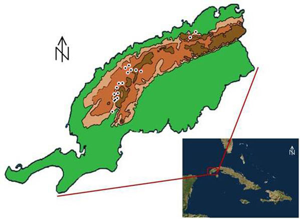 |
| Fig. 1.- Cartographic location
of the rock art stations evaluated in Guaniguanico Mountain Range, Cuba.
|
Crono-cultural
Relationship
The territory referred throughout this communication was evidently
inhabited in most parts by aboriginal people belonging to fisher-gathering
communities (Alonso, 1995 and Moreira, 1999), which were extended throughout
the Cuban island, and, deduced by the evidences of the archaeological
registration, they occupied practically the whole geographical space of the
current provinces of Pinar del Río and Artemisa.
The prints of the passing of farming groups for this area, are so far
quite dispersed and reduced, what seems to indicate that theirs arriving to this
area was still in the exploration and recognition phase, and not in the
conquest and occupation stage. This has been able to be interpreted by the
study of the archaeological pieces recovered in places and caves of the provinces
Pinar del Río, Artemisa, Havana and Mayabeque; or by the pictographs registered
and documented in caves such as Pluma, García Robiou and Solapa de la
Perdiguera, in the provinces of Matanzas, Mayabeque and Pinar del Río,
respectively. On the other hand, the permanent and stable establishments of
agricultural aboriginal populations in the west region of Cuba, took place
after the collision with the Europeans, as well as can be interpreted through rock
art manifestations like "the bovine" found in the cave system Guara,
in Mayabeque territory, or as can be demonstrated it the transculturation´s
ceramic sample in Guanabacoa, where the Europeans forced an aboriginal
establishment.
Because of what has been previously expressed, we should consider that
the fisher-gathering-hunting communities were very probably those that executed
the generality of the well-known rock art manifestations in the region,
accepting that the inherited registrations of these groups seem to be
characterized by a tendency toward abstract forms and simple geometric
representations, standing out the concentric circles.
It is also characteristic of these human collectives a style of chaotic
lines, without order neither reason, as if the artist follows with the
instrument the sinuosities that the selected support capriciously imposed, and
where the stains are also common (Fernández et.
al. 2009b), it also has been possible to appreciate that they used red and
black colours like the more frequent ones (Moreira, 1999 and Fernández et. al. 2009b). Many of these elements
are common in the studied stations, as well as the use of red and black
pigments, which were used in 88% of the total of the analyzed places.
Authors like Rosa (1996), Alonso et.
al. (2002) and González (2008) outlined that several stations can be
associated with the drawing art of African origin, linked to the graphic
expressions of the fugitive slaves of the coffee and sugar plantations that
were abundant in the area between XVI to XIX centuries.
The radio-carbonic dates available for this territory were unfortunately
not carried out directly on the rock art, but in the archaeological
registrations rescued in archaeological locations, so they are associated to
the base material found in the rock art stations.
In this sense, we should assume that the manifestations were carried out
by fisher-gathering-hunting aboriginal communities, in one period between 3320
a.n.e. as earlier limit and 1200 d.n.e, as the late one, considering that the
earlier dated one belongs to Cueva de la Lechuza in San Cristóbal municipality,
with 5270 + 120 AP, and the latest to Mogote de la Cueva in Pinar del Río municipality
with 650 + 200 AP (Pine, 1995: 2 and 5). However, the authors consider that
this proposal should be taken just to orientate the research, first, because
the experience has demonstrated that it is not always opportune to link the
archaeological registration located in the rock art station, directly with the
drawings, and second, due to the fact that there aren't enough quantity of
absolute dates to carry out a good association between both elements.
It can be also deduced that for the few stations that are considered as
the fruit of the ideological and cultural activity of the communities
well-known as Farmers, Agroalfareros or Islander Taino, one of the authors
(Fernández, 2012) has achieved the identification of numerous designs
characteristic of their iconography and even some ideographic representations
that remember to the deities of the mythological vault of these groups common
to Cuba and other Antilles islands. That allows assuming as executioners of
these graphic registrations to members of the Arawak linguistic branch with a
producer economy and a social gentile organization (Tabío and King, 1966: 202;
Guarch, 1978:108), Agroalfarero (Dacal and Rivero de la Calle; 1986: 140;
Tabío, 1991: 23), nowadays denominated Farmers (Moreira, L., 1999: 149). In
their unavoidable advance toward the occident of the national territory, they
already began the marks that defined the new landscapes that constituted
unequivocal samples of the passing by of a socially different group for the
territory, to settle down and with other patterns to the selection of the
sacred spaces.
In accordance with the radio-carbonic dates of the farming places
obtained to Cuba, it can be determined that this stage was developed among 820
DNE (1120 + 160 to. AP), according to the older dated one obtained in Residuario
del Paraiso in Santiago de Cuba (Pino, 1995: 10) and 1785 DNE (165 + 60 to.
AP), obtained for Aguas Gordas in the eastern Holguín province (Pino, 1995:
11).
THE ENVIRONMENTAL AFFECTATIONS
TO THE ROCK ART HERITAGE
The threats to the rock art were explained in extensive in the article
"The conservation of the Cuban rock art patrimony. Current situation and
perspectives" that was published in Boletín del Gabinete de Arqueología
(Gutiérrez, Fernández and González 2007). In this occasion, and seeking to be
more precise, a specific area of the Cuban territory has been selected to deepen
in the study of its deterioration and the threats that this archaeological
region faces.
The particular
study of the environmental affectations to the graphic patrimony demanded to
divide the threats that it faces in four groups, to facilitate the better
analysis of the damages. The classification had the origin of the damages as a premise,
and they were differentiated in Natural, Industrial, Anthropic and Cultural;
those that are integrated by other groups, in dependence of the type of
affectation.
Natural Threats
The
threats denominated natural are those
that appear as a result of the planetary typical processes of nature, in which
the man doesn't have a primary or direct participation, such as the geological,
carsological, biological or climatic alterations. Since the point of view of
their categorization they can be subdivided in the following categories or
types:
Geologic: In this group are included the damages taken place by
the formation of deposits of carbonates on the areas with graphic
representations; also those detachments or collapses of blocks or fragments of
rocks as a result of the structural adjustment of the localities. The cracking
or scaling is also included; it happens when there is cracking or jump of small
parts of the support that contains the graph, because of the same causes that
the fragmentation occurs.
Biological: Here are included the
damages caused by the natural growth of mushrooms, lichens, mosses, algae,
ferns and other vegetable organisms, on the supports in which the graphs were
carried out. Another common phenomenon is the faecal ejections of bats,
rodents, birds and other permanent or eventual inhabitants of the stations; as
well as the action taken place by some animals when moving on graphs, or the
construction of honeycombs and nests by insects and birds.
Climatic: In this kind of
threat are included the eolic erosion, the changes of humidity –relative
and absolute– in the caves environments, as well as the evaporation,
condensation, pressure of CO2, oxidation, and other microclimatic variables.
Industrial Threats
Those denominated industrial
threats, are all the actions provoked by modern man as secondary effect by
modifying the environment and the ecosystem that surrounds the stations, with the
purpose of increasing the economic and industrial development.
It has been observed that in occasions, when there is a reference to the
environment of the rock art stations, it is common to think in the space
surrounding it, however meticulous field studies have demonstrated, for example,
that the effects of the emanations of hidrosulfhuric gas of petroleum wells in
the north coast of Havana province, have provoked the decalcification of the
calcareous rock of the caves located in a radio of 5 Km of distance. The
pictographs of Cinco Cuevas cave have been hopelessly lost due to the scaling
of the rocky surface off.
The damages of industrial type can be divided in the following
categories:
Mining: Linked fundamentally to the exploitation of quarries
and the explosions taken place during the mining process. It is also considered
the smog emanations and other gases like residual aerosols characteristic of
the extraction of petroleum, natural gas, etc.
Constructive: They are
associated to the construction of highways and the continuous vibrations taken
place by the circulation of heavy vehicles; also, it should be considered the
construction of dams and the adaptation of areas for the storage of toxic
substances, chemical, and hydrocarbons, as well as the creation of micro urban
towns near to the stations.
Agricultural: They are those related with the agricultural, cattle
raising and forest processes; as well as the deposition of stones, industrial
and crops waste, domestic garbage, etc. in the cavities. It is included the treatment
of ground for multiple agricultural activities that provoke microclimatic
changes as product of deforestation and/or reduction of the edaphic layer around
caves or rock shelters. Also the livestock breeding (bovine, porcine, etc.)
that establish room spaces in the caves to be protected of the sun and, they
rub their body against the walls with pictographs or petroglyphs, provoking
climatic and microbiological changes that in short and long term should
deteriorate the rock paintings.
Anthropic threats
The anthropic threats represent the actions
carried out by modern man to the rock art stations and their environment in a
direct and intentional way. These constitute, without doubts, the most abundant
and devastating damages that these ancient cultural manifestations continually
receive in whole world and Cuba is included in this reality.
Graffiti: It is the damage
that has impacted the most the drawing stations in the country during the last
three centuries. It consists on "decorating" the walls of the caves
with signs of all kind, dates and drawings in occasions, which can be done with
any material as pencils, crayons, spray or diverse varieties of pigments with
acrylic and oil bases.
Rockets: It refers to two
kinds of practices with similar consequences: the first, to shoot guns toward
the drawings; and the second one, to throw all type of objects toward the walls
or the secondary formations that support the graphic manifestations.
Overload: With this term are
defined those procedures like the use of water or chalk on the pictographs
and/or petroglyphs with the intention of improving the visibility and
perception of them, but also it is included the contoured of the pictographs or
petroglyphs to define and to stand out their borders. All these actions are executed
mainly by the researchers to take the pictures or the tracing of the
registrations for its documentation. The same overload takes place when someone
light blazes or burn tires inside caves and rock shelters (2).
Cultural: The lack of
transmission to the villagers and neighbours of the information about an
archaeological site´s discovery produces the destruction or affectation of the
station because of different reasons. The researchers are the main responsible
of creating false expectations and concerns around the sites, instead of
facilitating the custody and protection.
2. It is a very habitual practice among
the peasants, beaters, fishermen and campers, to mark the walls with smoke,
soot, coal, powder and other toxic substances provoking the decalcification of
the rock due to oxidation.
|
EVALUATION AND DIAGNOSIS OF
ROCK ART HERITAGE
From the beginnings of Archaeology as a science, the protection of
archaeological heritage has been one of their specialists' interests, although it
has enjoyed either successes or failures in dependence on the scientific vision
of the moments they lived.
In our country, different institutions from the beginnings of XX century
have settled down –by means of important regulations– the handling
and conservation politics of the archaeological/historical places (3); also during the
revolutionary period many laws and ordinances for the patrimonial protection
have been carried out, modified and applied. At the same time, institutions
have been created for archaeological research and the heritage management, which
have organized and carried out campaigns to rescue and salvage the places and
locations; however, the lack of control and constancy on the state,
conservation, and even on the strategies to continue the excavations of the
places, have provoked their hopeless affectation, so the situation of the
archaeological heritage is in sensitive damage at this moment (Robaina 2003).
3. Magazine of Archaeology and Ethnology, Special Number on Legislation,
year 1957; Protection of the Cultural Patrimony. Compilation of legislative texts, Ministry of
Culture, Havana, 1996.
|
The Cuban rock art patrimony is not an exception in the destruction of
its stations, that is why a strategy became necessary to discern the main
damages and threats that deteriorates it, and to design the instruments to
maintain its preservation. So a methodology was implemented able to identify at
least the main threats.
For the study it was used the Methodology for the Evaluation of the
Environmental Impact in the archaeological places, proposed by members of the
Group of Auxiliary Sciences of the Department of Archaeology in the Cuban
Institute of Anthropology, belonging to the Ministry of Science, Technology and
Environment (CITMA), in which the Indicators are evaluated for each impact:
sign, intensity, extension, moment, persistence, reversibility, recoverability,
synergy, accumulation and rhythm or periodicity.
In the case object of analysis the attention was directed in those
indicators that, in the best way, express the level and the intensity of the
affectation: the Accumulative Effect, in which the inductor agent's
action is prolonged in time, being its graveness progressively increased when
the environment lacks of elimination mechanisms. It happens, for example, in
the stations that the action of felling the surrounding vegetation provokes the
systematic loss of the coloration of drawings because of the daily incidence of
solar rays.
Synergistic Effect: It is considered when several combined impacts take
place and it is verified by the simultaneous presence of several actions. The
graveness is that the environmental incidence that takes place most be bigger
than the supreme effect of the individual ones contemplated in isolated way.
Enough examples of rock art stations exist where, due to the felling of the
surrounding vegetation, they began to face strong changes of temperature
between day and night. Fractures in the rock are the redundant consequence that
contribute to the establishment of diverse opportunists microorganisms –lichens,
mushrooms, superior plants– those which produce acids in the
photosynthesis process destroying the stony support, besides the loss of
coloration of the pictographs because of heatstroke.
Recoverability Effect: It is focused in the loss of a patrimony that is impossible
to repair, either for natural or human action. Many pictograms have been
attacked by the overwriting and graffiti’s execution that can be eliminated by
lingering and expensive chemical processes; but the operation is potentially
risky due to the alteration or mutilation of the petroglyphs, that can be
transformed into an irreparable condition.
The importance of being able to carry out the evaluation and the diagnosis
of the environmental impacts in the archaeological places consists on the
possibility of planning short trips to the different areas of the national
territory with or without risks of modifications, affectations or destruction.
The objective of those trips is to make quick and reliable valuations that
allows –by a transverse study– to know the real situation of the
study areas, or, in a random way, to select a proportional number of places
that facilitates the analysis of the approximate state of the general total
(Fernández et. al. 2009a).
During the analysis that was carried out to determine the way to proceed
for this particular case, it were randomly selected 17 rock art stations of the
37 ones that the studied region possesses, to obtain a general approached
vision of the impacts that are creating a bigger number of affectations in the
same ones, and to carry out the pertinent recommendations to eliminate or to
mitigate the damages occurred.
The systematic monitoring and evaluation of the situation of rock art stations
at a national level carried out by the Cuban Group of Rock Art Researches
(GCIAR) shows the presence of an important number of threats that ascends to
17% the industrial ones and to 83% the anthropic ones. Just 23% of the total of
274 stations reported in the country, is only protected with Monuments´
categories, and only15% is included inside the areas of National Parks and
Natural Reservations. Until now, these historical–cultural values haven´t
been taken into account for they to have the necessary exclusion or protection
areas inside those protected regions.
MUNICIPALITY
|
ROCK ART STATIONS WITH LEGAL PROTECTION
|
LOCAL MONUMENT
|
NACIONAL
MONUMENT
|
IN PROTECTION AREAS
|
WITHOUT PROTECTION
|
Guane
|
|
|
|
2
|
Minas
de Matahambre
|
1
|
|
|
10
|
Viñales
|
3
|
1
|
9
|
-
|
La
Palma
|
1
|
|
1
|
4
|
Pinar
del Río
|
|
|
|
1
|
Candelaria
|
|
|
|
1
|
Bahía
Honda
|
1
|
|
|
2
|
San
Cristóbal
|
|
|
|
4
|
TOTAL
|
6
|
1
|
10
|
24
|
|
Chart No. II.- Behaviour of
the legal protection of rock art stations of Guaniguanico Mountain Range.
|
THE EXPERIENCE IN GUANIGUANICO
MOUNTAIN RANGE. SELECTION OF THE
SAMPLE
To apply the elected methodology 17 caves and rock shelters with rock
art manifestations were selected from 3 of the municipalities that have most representativeness,
which were Minas de Matahambre, Viñales and Bahía Honda, and a cave of La Palma
municipality.
It was decided then to carry out the journey during several days with a
chronogram that admit to carry out the visits with a minimum time calculated in
2 or 3 hours by station, to evaluate satisfactorily the actions and the present
impacts. During the inspections each site was graphic and photographically
documented with the impacts detected to maintain a systematic control of the
positive or negative evolution of the same ones.
The rock
stations
Topographically the stations are located among 0 m. and 253 m. of
altitude on the sea level, establishing the limits Solapa de la Vaquería and
Cuevas del Garrafón, respectively.
In general, these manifestations of the culture material can be found in
caves –as those of Cueva del Cura and El Garrafón– that present a
few longitudinal development, among 20.0 m. of Cueva de las Manchas and more
than 700 m. of Cueva de los Petroglifos; but it reaches their maximum exponent
in 2 500 m. of Cueva de Mesa; or in big rock shelter that reach in occasions
among 2 m. and 10 m. of depth like Solapa de la Vaquería y la Cueva de Las
Manchas, respectively.
Realization
Substrates
The selection of the realization substrate in the group of stations that
we analyzed it is determined by three categories, those that can be defined as:
walls and roofs of the cavities, secondary formations (lytogenesis) and clastic
morphology (blocks of collapses).
According to the
established categories the use of the walls and roofs as substrates represent
97%, in opposition to 1% and 2% of use of the secondary formations and the clastic
morphology, respectively.
The use of the cave support from the point of view of the composition
allows settling down that the pictographs are present in the three categories
of selection of realization´s substrates, and that the petroglyphs were carried
out in the walls and roofs of the stations.
Assignment of
spaces
The assignment of spaces as a concept in the studies of the Cuban rock
art registration have gotten a special interest in the last years, starting
from the approach of some researchers that the study of this element can bring
cultural and chronological elements (Fernández and González, 2001; Fernández
2005), accepting the precepts settled down by archaeology of landscape and the
selection of the spaces where to execute the rock designs.
No.
|
NAME
|
LOCATION
|
1
|
Solapa
de La Sorpresa
|
Sierra
del Pesquero
|
2
|
Cueva
de Camila
|
Sierra
de Mesa
|
3
|
Solapa
de La Perdiguera
|
Sierra
de Sumidero
|
4
|
Cueva
de Nicolás
|
Sierra
de Sumidero
|
5
|
Solapa
de Los Círculos
|
Sierra
de Cabeza
|
6
|
Solapa
de Los Pintores
|
Sierra
de Cabeza
|
7
|
Solapa
de Quemado
|
Sierra
de Quemados
|
8
|
Cueva
de Mesa
|
Sierra
de Quemados
|
9
|
Cueva
de Los Petroglifos
|
Sierra
de Galeras
|
10
|
Cueva
del Garrafón
|
Sierra
de Viñales
|
11
|
Cueva
de Las Manchas
|
Sierra
de San Vicente
|
12
|
Solapa
de La Vaquería
|
Sierra
de San Vicente
|
13
|
Cueva
de Los Estratos
|
Sierra
de San Vicente
|
14
|
Cueva
del Cura
|
Sierra
de Guasasa
|
15
|
Solapa
María Antonia
|
Sierra
de Gramales
|
16
|
Cueva
La Espiral
|
Macizo
Pan de Guajaibón
|
17 |
Cueva Canilla II
|
Macizo Pan de Guajaibón
|
|
| Chart III.- Stations selected
for the evaluation and diagnosis of the environmental impact study in
Guaniguanico Mountain Range.
|
One of the analysed approaches was the area of execution of the
manifestations in correspondence of the incidence of solar rays in the
underground space. In the studied stations it behaved as follows: 11 places
manifest their representations in areas where the sunbeams impact directly
(thresholds areas), 2 stations show their exponents in areas where the solar rays
infiltrates by reflection (sub thresholds areas) and 4 sites exhibit their art manifestations
in areas where it never impacts the solar light (absolute darkness).
With the use of
these approaches, it could be observed in details that it is established that
the most used space was that of the sub thresholds areas, what represents 65% of
selectivity; so the presence of rock drawing in the thresholds and sub thresholds
areas is unequivocally related with pictographs. At the same time it is curious
and also proven, the fact that all the petroglyphic stations of the mountain
range had assigned the area of Absolute Darkness as space.
Evaluation and
diagnosis of the conservation
As it was explained at the beginning of this presentation, for the
evaluation and the diagnosis of the conservation´s grade of rock drawing of the
mountain range object of study, the research began using the 28 types of
actions proposed before in the mentioned study, but throughout the
investigation it was proven that these categories were insufficient, that is
why some necessary modifications were introduced and the same ones were
enlarged until a number of 34, at the same time that we were studying new areas
and that we faced the particularities of the human activity.
The evaluation of the state of conservation of the drawings allowed
verifying that the lichens, mosses or microorganisms development is the impact
that affect the sites the most, with a presence of 84%; what is in consonance
with deforestation, the action that biggest representation shows, in 70%.
GROUP
|
CATEGORY
|
ACTION
|
AFFECTED
STATIONS
|
Naturals
|
Geological
|
Expansion-contraction
of rock support
|
2
|
Collapses
|
-
|
Forming
of carbonate deposits
|
3
|
Biological
|
Construction
of insects´ honeycombs
|
2
|
Growing
of lichens, mosses and microorganisms
|
13
|
Deposition
of fecal ejections
|
2
|
Action
of moving animals
|
1
|
Climatic
|
Expansion-contraction
of rock support
|
1
|
Erosion
Eolic
|
11
|
Humidity,
evaporation, pressure and condensation
|
3
|
Changes
of water´s pH.
|
-
|
Industrials
|
Mineralogical
|
Expansion
of quarries
|
-
|
Smog
and other dusts and residual aerosols
|
5
|
Explosions
|
3
|
Constructing
|
Construction
of roads
|
1
|
Accumulation
of toxic substances and hydrocarbons.
|
1
|
Construction
of dams
|
-
|
Other
constructions
|
4
|
Agriculture and cattle
|
Construction
of corrals for breeding of minor cattle
|
1
|
Cavities´
filling with solid residues
|
2
|
Deforestation
|
7
|
Extraction
of soil and bat´s droppings
|
2
|
Anthropic
|
Graffiti
|
Drawing
inscriptions
|
3
|
Rockets
|
Rockets´
impacts
|
-
|
Throwing
of objects
|
-
|
Overloads
|
Contouring
samples
|
2
|
Refilling
with paints
|
-
|
Chalking
|
-
|
Emphasizing
with water
|
2
|
Smoke,
soot, coal and dust
|
1
|
To
enumerate
|
1
|
Cultural
|
Visits
without control
|
5
|
Deficient
transmission of the cultural value
|
16
|
Habilitation
of sites
|
1
|
Restoration
|
1
|
Total of affected stations
|
16
|
|
Chart IV.- Main
threats for the rock art drawing of Guaniguanico Mountain Range
|
Thanks to the fact that the stations of the mountain range, in a general
sense, are located in remote and distant places of urban cities and towns, the
graffiti doesn't constitute one of the most frequent environmental impacts, as
has been demonstrated by the studies carried out at national level (Fernández
and González 2001, and Gutiérrez et. al.
2007).
KIND OF ACTION
|
IMPACTS
|
Deforestation
|
Provokes
growing of microorganisms and micro flora on the paintings in the threshold
zone, due to the sunbeams.
|
Eolic
Erosion
|
Loosing
of the pigment layers in some paintings.
|
Contouring
of painting´s borders
|
Contouring,
maybe with graphite, of painting´s borders, for better recognizing.
|
Growing
of lichens, mosses and microorganisms
|
Growing
of stains that cover the paintings partial or totally.
|
Humidity,
evaporation, pressure and condensation
|
Growing
of calcite layers on the paintings.
|
Visits
without control
|
Construction
of hearths and fires that spread smoke and ashes on the pictographs.
|
Direct
action of visitors on walls and paintings.
|
Accumulation
of solid waste.
|
Expansion-contraction
of rock support
|
Cracking
and loss of the pigment layer in paintings.
|
Extraction
of soil and bat´s droppings
|
Uncontrolled
extraction and movement of archaeological evidences.
|
Construction
of corrals for breeding of minor cattle
|
Deposition
of fecal ejections that modify soil´s pH.
|
Movement
of soil.
|
Growing
of microorganisms and micro flora.
|
Deposition
of fecal ejections
|
Increasing
of acidity and degradation of walls and paintings.
|
Loss
of the color of paintings.
|
Intention
to restore
|
Contouring
samples
|
Retouching
of affected areas with clay.
|
Construction
of insects´ honeycombs
|
Formation
of concretions on walls and paintings.
|
|
| Chart V.- Impacts that affect
the rock drawing of the stations evaluated in Guaniguanico Mountain Range.
|
The impact denominated graffiti was detected in the evaluated stations Cueva
de los Estratos, Nicolás and Camila, those that coincidentally are near the
areas of more affluence of people, and they are also frequently visited by
outsiders, furtive hunters, occasional tourists and vacationers, what have
provoked adverse effects on the drawings.
The places with more variety of present kind of impacts are Cueva de Camila
affected with 12, the Cueva de la Tabla for 8, and Cueva de Nicolás for 5.
Solapa de la Vaquería with 7, and Solapa de Las Manchas affected with 6 types of impacts
are the ones that continue this lamentable list (González, et. al. 2007).
It could be proven that Los Estratos´, Camila´s and
Nicolás´ Caves, and Las Manchas´ and La Vaquería´s Rock shelter, are the stations
that present bigger risks because of the intensity of the impacts detected inside,
the ones that were evaluated with the category of "Very High
Affectation".
The bigger impact that provoked this result was the development of civil
constructions in the range between 2 and 30 m. of the stations, what has
generated violent impacts because of the dust and residual aerosols aggravated
by the arid soil movement in lingering and intense periods, and the effect of
explosions, actions linked to the partial or total deforestation of the areas, that
indirectly affected those sites.
Cueva de Nicolás' station is located next to the highway that goes to
Sumidero town, what transforms it into a public sanitary service, because it
doesn't have any mark or signal that points out its patrimonial and cultural
value.
There are also several rock art stations that have been protected for
been included in the areas belonging to National Parks or Reserve of Biosphere
that have Guard Parks or Guard Forests systems. The efforts that have allowed a
better protection of those stations, have being proving the remarkable decrease
of the affectations to pictographs and petroglyphs (Fernández et. al. 2012).
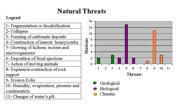 |
Fig.
2.- Graph of the types of natural threats that affect the rock art stations.
|
In this sense the cavity well-known as Cueva de Mesa in Gran Caverna de
Santo Tomás, is the only one that has specialized guide service, for being located
in the territory belonging to Viñales National Park, and in the properties of
the former National School of Speleology, that had an obligatory access through
a Control Post.
The
tourist exploitation of Gran Caverna de Santo Tomás system began at the end of
the nineteenth decade, for that reason new entrances to the cavity were created
to facilitate the tourism journeys. Unfortunately, the evaluation that was
carried out to determine the possible affectations that the station would
receive it was incorrect, accentuated by the absence of a systematic monitoring
and by the out of control in the access, linked to the direct contact of
irresponsible excursionists and the increase of the continuous flow of air from
the cavity, what has provoked the irreparable deterioration of the petroglyphs.
A community of investigators of the county tried to restore some of the
engravings applying some splashes of carbonate sand, obtained from the area
around of the petroglyphs, by the using of a dental brush like a rustic aerosol
for that, and the using of a sharp instrument to emphasize them.
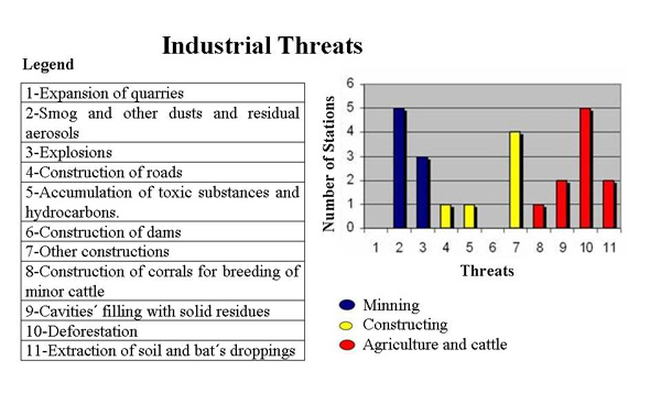 |
Fig.
3.- Graph of the types of industrial threats that affect the rock art stations.
|
This inadequate procedure didn't have the registration and documentation
of the original petroglyphs, neither of the elaboration of the file that
documented the whole process with the description of the applied procedure.
This action introduced to the painting mural an unimaginable number of
microbiological and microclimatic dangers that cannot be valued nowadays; also
the completely perceptible morphological modifications.
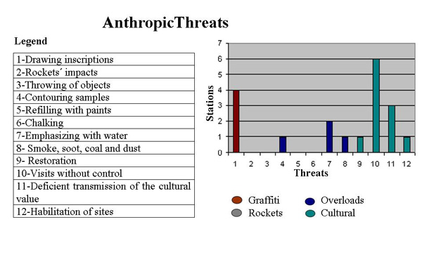 |
Fig.
4.- Graph of the kind of anthropic threats that affect the rock art stations.
|
The
institutions involved in the research, conservation and safeguards of the
cultural and natural patrimony are the direct responsible of making that the
laws that protect our heritage be worth at every level. They also should unite
their efforts to achieve the execution of the effective dispositions and to
correct or complete the corresponding documentation for their correct safeguard.
Hence,
it can be confirmed that the state of conservation of the rock drawings present
in the stations of Guaniguanico Mountain Range, are classified in the category
of "High Affectation"; that is why it is imminent the necessity that
the structures of the municipal governments of this region, consider this
patrimony as one of the most fragile cultural resources and in consequence they
act to protect it.
No.
|
NAME
|
AFECTATION GRADE
|
1
|
Solapa de La Sorpresa
|
3
|
2
|
Cueva de Camila
|
1
|
3
|
Solapa de La Perdiguera
|
2
|
4
|
Solapa de Los Círculos
|
2
|
5
|
Solapa María Antonia
|
4
|
6
|
Solapa de Los Pintores
|
4
|
7
|
Solapa del Quemado
|
3
|
8
|
Cueva de Mesa
|
1
|
9
|
Cueva de Los
Petroglifos
|
4
|
10
|
Cueva del Garrafón
|
3
|
11
|
Cueva de Las Manchas
|
1
|
12
|
Solapa de La Vaquería
|
1
|
13
|
Cueva de Los Estratos
|
1
|
14
|
Cueva del Cura
|
3
|
15
|
Cueva de Nicolás
|
1
|
16
|
Cueva Canilla II
|
2
|
17
|
Cueva La Espiral
|
4
|
|
Chart
VI.- Grade of general affectation for station.
Legend:
Very High Affectation (1), High Affectation (2), Moderate (3), and Slight Affectation
(4)
|
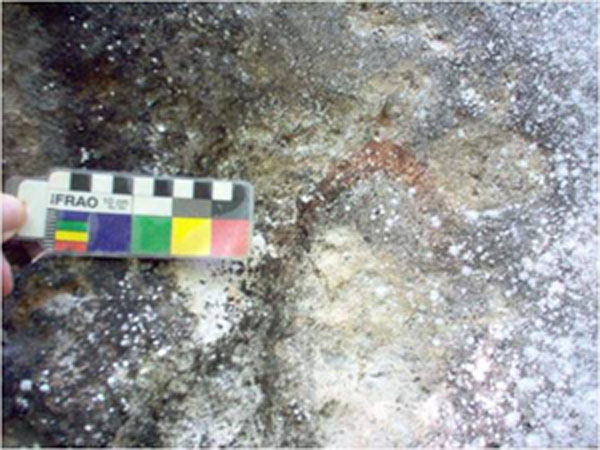 |
Fig. 5.- Solapa de la Sorpresa in Sierra del Pesquero.
Painting affected by the growth of microorganisms on
the wall (files of GCIAR).
|
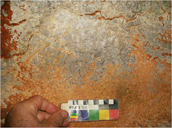 |
Fig. 6.- Cueva La Espiral in
Macizo de Guajaibón.
Formation of
deposits of carbonates (the authors' files).
|
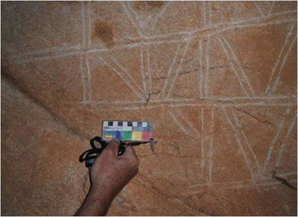 |
Fig. 7.- Cueva de Mesa in Gran
Caverna de Santo Tomás.
Contouring
restoration by incised lines (files of GCIAR)
|
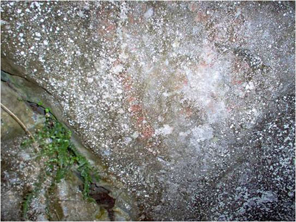 |
Fig. 8.- Cueva de Nicolás
in Sierra de Sumidero.
Growth
of microorganisms on the rock support (files of GCIAR).
|
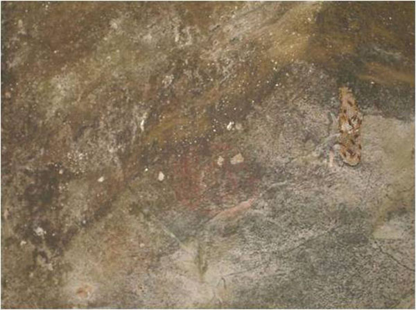 |
Fig. 9.- Solapa de los Círculos in
Sierra de Cabeza.
Development of insects´ honeycombs (files of GCIAR).
|
CONCLUSIONES
The impacts that bigger number of affectations are creating in the visited stations, are the wrong antrophic manipulation of the ecosystem around them that provoke secondary effects such as the presence of microorganism, plants, ans zoological opportunist species that irreversibly damage ythis millennial heritage.
The country has the legal corpus that should guarantee the protection ans conservation of the Cultural Heritage, but regrettably it doesn´t mention the rock art as the specifities included, such as architectural elements, among otrhers. In this sense, and taking into account the proposals resulted in the International Consulation of Specialis´t in Study, Documentation and Conservation of the Rock Art, celebrated in Valmónica in 1981, we are agree with the approach that the necessity to establish a corpus of particular laws, for the heritage protection, conservation, administration, use and handling, is unavoidable.
The institutions involved in the research, conservation and safeguards of the cultural and natural heritage are the direct responsible of applying the laws that protect our heritage, and of achieving the execution of the dispositions for their correct preservation.

—¿Preguntas,
comentarios? escriba a: rupestreweb@yahoogroups.com—
Cómo citar este artículo:
Ortega, Fernández Racso; Morales Valdé, Dany;
Hernández Rodríguez, Dialvys y Villate Cué,
Victorio
An analisis of the evaluation and diagnostics to environmental
impacts in rock art stations of Guaniguanico Montain Range, Cuba
En Rupestreweb, http://www.rupestreweb.info/guaniguanico.html
2013
REFERENCIAS
Alonso, E. M. (1995): Fundamento
para la historia del Guanahatabuey de Cuba. Editorial Academia. La Habana.
Alonso, E. M., C. Rosa, C. Guanche, H. Carmenate, D. Rodríguez, M. R. González y E.
Blanco. (2004): “Pinar del Río: Arte
Rupestre”, CD-ROM II Taller Internacional
de Arte Rupestre, La Habana.
Comité Estatal de Estadísticas (1981): Estudio sobre la
Cordillera de Guaniguanico. Censo de
población y vivienda. Marzo de 1981. Instituto de Demografía y Censos.
36pp.
Corvea, J. L.; R. Novo, Y. Martínez, I. de Bustamante y J.
M. Sanz, (2006): El Parque Nacional Viñales: un escenario de interés geológico,
paleontológico y biológico del occidente de Cuba. En Trabajos de Geología, Univ. de Oviedo, 26: 121-129.
Dirección de Patrimonio Cultural (1996): Protección del Patrimonio Cultural.
Compilación de textos legislativos, Ministerio de Cultura, La Habana.
Fernández, R. y J. B. González, (2001):
Afectaciones antrópicas al arte rupestre aborigen en Cuba. Rupestre Revista de Arte Rupestre en Colombia, Año 4, No. 4,
Bogotá.
Fernández, R. (2005): “El registro gráfico rupestre como fuente de información Arqueológico-antropológica.
La Caverna de La Patana, Maisí, Guantánamo, Cuba”. Tesis en Opción
al Título Académico de Máster en Antropología Sociocultural. Facultad de
Filosofía e Historia, Universidad de la Habana (inédito).
Fernández, R.; D. Morales; Y. Cordero; J. G. Martínez; V. Cué; J. B
González; L. Torres; S. T. Hernández; H. Carmenate; J. A. Amorín; I. Hernández
y D. Gutiérrez; (2009a): La evaluación y el diagnóstico del estado de conservación del
patrimonio arqueológico de Cuba.
Fernández,
R., J. B. González y D. A. Gutiérrez (2009b): History, Survey, Conservation, and Interpretation of Cuban Rock
Art. [with translation by Michele H. Hayward]. In Rock Art of the Caribbean. Editores Michele H. Hayward, Lesley-Gail Atkinson y Michael A. Cinquino. The University of Alabama Press, Colección Caribbean
Archaeology and Ethnohistory Series: 22 - 40. Tuscaloosa.
Fernández, R.; D. Morales; D. Rodríguez y V. Cué (2012): Arqueología y turismo en Cuba.
¿Simbiosis para el desarrollo sostenible? Boletim do Museu Paraense Emílio Goeldi “Ciencias Humanas”, Belem,
Brasil. (En prensa).
González, J. B.; R. Fernández, D. Gutiérrez, H.
Carménate, Y. Chinique y D. Rodríguez (2007) Reporte del trabajo
realizado en 13 de las estaciones de arte rupestre de la provincia de Pinar del
Río. Proyecto de evaluación y diagnóstico del patrimonio sociocultural de
Cuba. Archivos del Dpto. de Arqueología del Instituto Cubano de Antropología,
La Habana.
Gutiérrez, D.; R. Fernández,
y J.
B. González. (2007):
La conservación del patrimonio rupestrológico cubano. Situación actual y
perspectivas. En Boletín del Gabinete de Arqueología, Oficina del Historiador de la
Ciudad, Año X, (X): 107-124.
Junta Nacional de Arqueología y Etnología (1957): Número
Especial sobre Legislación, Revista de la Junta Nacional de Arqueología y
Etnología, Época 3ra., La Habana.
Robaina, J. R; M. Celaya; O.
Pereira; R. Rodríguez (2003): Gestión y
manejo de recursos y valores arqueológicos patrimoniales de la República de
Cuba. Monografía (inédita). Fondos Documentales del Instituto Cubano de
Antropología. Resultado de Investigación.
|