A new (?) geoglyph in the department of Arequipa, Peru.
Un geoglifo nuevo (?) en el departamento de Arequipa, Peru
This short note describes the recording of
a geoglyph in the Department of Arequipa in the south of Peru. Because the
geoglyph is located at an easily accessible spot, I will not reveal its exact
location here.
Esta
nota corta describe el registro de un geoglifo en el Departamento de Arequipa
en el sur de Perú. Como el geoglifo está localizado en una zona fácilmente
accesible, no revelaré su posición exacta aquí.
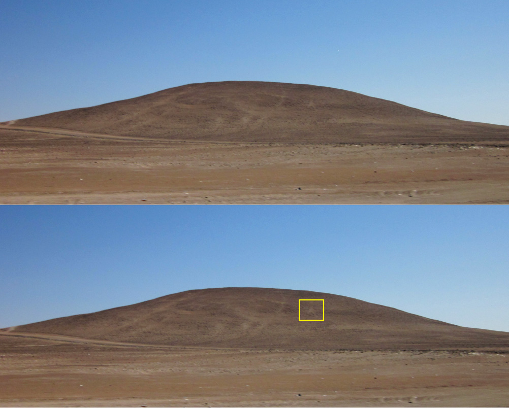
The geoglyph was spotted by my wife Elles and
me during one of our trips in the Peruvian desert. The figure is located on the
SW facing slope of a low hill at about 1230 m. O.D. (Figure 1). The base of the
hill is at 1210 m O.D., so the geoglyph is at about 20 m above ground level. As
it is on a gentle slope, it is not very conspicuous. Moreover, the geoglyph,
made by removing small stones from the soil to create a fully filled-in (not
outlined) figure, has almost the same colour as the surrounding area.
El geoglifo
fue advertido por mi esposa Elles y yo durante uno de nuestros viajes en el
desierto peruano. La figura está localizada en una pendiente sudoeste de una
colina baja, en aproximadamente 1230 m.s.n.m. (Figura 1). La base de la colina
está en 1210 m.s.n.m., entonces el geoglifo está en aproximadamente 20 m sobre la
superficie del suelo. Como el geoglifo está en una pendiente suave, no es
muy visible. Además, el geoglifo, se realizó quitando pequeñas piedras del suelo
para crear una figura totalmente rellena (no perfilada), tiene casi el mismo
color que el área circundante.
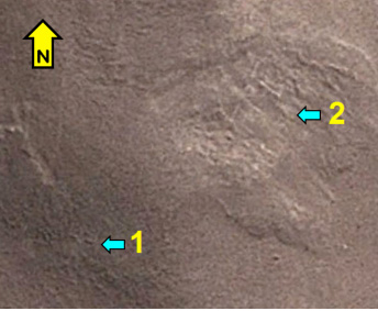
This latter fact together with the subject
matter of the figure makes me to suggest that it is a Pre-Columbian figure. The
geoglyph (indicated with blue arrow 1 in Figure 2) notably is an
anthropomorphic figure with both arms raised; a typical posture for
Pre-Columbian anthropomorphs in Andean rock art. Yet, I am no expert on
geoglyphs and thus I invite experts in this area to survey the site and to
establish whether indeed the figure is a true geoglyph (Google Earth KMZ-file
available). On the same hill are other markings (indicated with blue arrow 2 in
Figure 2) that also may be geoglyphs. However, I have only seen Geoglyph 1 in
the field. The other markings showed up when using Google Earth.
Estas caracteristicas junto con el tema de la figura me sugiere que se trate de una figura precolombina. El geoglifo (indicado con la flecha azul 1 en la
Figura 2) parece ser una figura antropomorfa con los dos brazos levantados;
una postura típica para figuras antropomorfas precolombinas en el arte
rupestre Andino. Debido a que no soy experto en geoglifos invito a expertos en esta área a contemplar el sitio y establecer si en efecto
la figura es un geoglifo verdadero (KMZ-archivo de Google Earth disponible). En
la misma colina hay otras marcas (indicado con la flecha azul 2 en la Figura 2)
que también pueden ser geoglifos. Sin embargo, sólo he visto el Geoglifo 1 en el
campo. Las otras marcas se revelaron usando Google Earth.
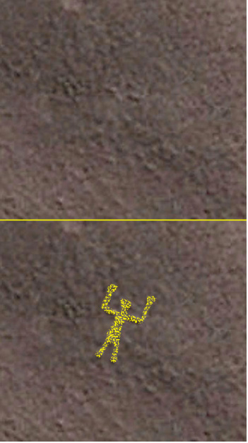
Because only very recently (2013) a high
resolution Google Earth Satellite Photo of the area of the hill became
available, I was only then capable to pinpoint the exact location of the
geoglyph. Geoglyph 1 showed up ‘rather’ clearly in Google Earth (Figure 3). The
SW facing geoglyph shows an anthropomorph with raised arms (especially the
hands could not be seen properly) and two slightly separated legs (Figure 4).
An estimation of the size, based on Google Earth, demonstrated that the figure
is about 15 metres tall and about 10 metres from one raised arm to the other.
Como
sólo muy recientemente (2013) se hizo disponible una fotografía satélite de alta resolución de Google
Earth del área de la colina , fui capaz sólo entonces de
señalar la posición exacta del geoglifo. El Geoglifo 1 se reveló ‘bastante’ claramente
en Google Earth (Figura 3). El geoglifo, orientado al sudoeste, muestra un
antropomorfo de brazos levantados (sobre todo las manos no podían ser vistas
correctamente) y dos piernas ligeramente separadas (Figura 4). Una valoración
del tamaño, basado en Google Earth, demostró que la figura es aproximadamente
de 15 metros de altura y mide aproximadamente 10 metros de un brazo levantado al
otro.
As far as I could check, this geoglyph has
not been recorded before. It does not appear in the extensive inventory by
Rainer Hostnig (2003: 43 to 64), although it may have been registered by
another name. Hostnig
mentions geoglyphs at Majes Tunel 8 (2003: 52); Pampas de Ocho (2003: 53);
Paruna (2003: 53); Siguas (2003: 60) and Toro Muerto (2003: 62). The entry
Pedregal (o Buena Vista) probably is a double entry referring to Pampas de Ocho
(2003: 64). Linares Málaga (2004: 73) lists further geoglyphs
at Barranca (this possibly is the same site as Cosos reported by Johan Reinhard
in 2008), Canal Santa Rita, Corire - Geoglifo en 8 (probably Pampas de Ocho)
and Santa Isabel, but the location details provided by Linares Málaga are
sometimes inaccurate or confusing.
Por
lo que yo podría comprobar, este geoglifo no ha sido registrado antes. No esta
registrado en el inventario extenso de Rainer Hostnig (2003: 43 a 64), aunque
pueda haber sido registrado con otro nombre. Hostnig menciona geoglifos en
Majes Tunel 8 (2003: 52); Pampa de Ocho (2003: 53); Paruna (2003: 53); Siguas
(2003: 60) y Toro Muerto (2003: 62). La referencia Pedregal (o Buena Vista)
probablemente es una referencia doble que se refiere a la Pampa de Ocho (2003:
64). Linares Málaga (2004: 73) menciona en una lista otros geoglifos en
Barranca (este posiblemente es el mismo sitio de Cosos reportado por Johan
Reinhard en 2008), el Canal Santa Rita, Corire - Geoglifo en 8 (probablemente
Pampa de Ocho) y Santa Isabel, pero los detalles de posición proporcionados por
Linares Málaga son a veces inexactos o confusos.
If this indeed is an unreported geoglyph and
is of Pre-Columbian age, it merits careful study and preservation, especially
as geoglyphs are easily destroyed (see for instance El
Comercio: 2012). Also this new (?) geoglyph is in an area that is changing
rapidly.
Si
este geoglifo en efecto no esta registrado y es de la época precolombina,
merece un estudio y preservación cuidadoso, especialmente porque los geoglifos son
fácilmente destruidos (ver por ejemplo: El
Comercio 2012). También este geoglifo nuevo (?) está en un área que cambia rápidamente.
|
Figure 1. The hill with the
geoglyph photographed from a distance of 380 m, looking NW.
Photograph
by Maarten van Hoek.
Figura 1. La colina con el geoglifo fotografiado desde una distancia de 380
m, mirando al NE.
Fotografía de Maarten van Hoek.
|
|
Figure 2. The geoglyph(s?) on
the hill.
Map by Maarten van Hoek; based on Google Earth.
Figura 2. El geoglifo en la colina.
Mapa by Maarten van Hoek; basado en Google Earth.
|
|
Figure 3. The geoglyph on the
hill.
Map by Maarten van Hoek; based on Google Earth.
Figura 3. El geoglifo en la colina.
Mapa de Maarten van Hoek; basado en Google Earth.
|
|
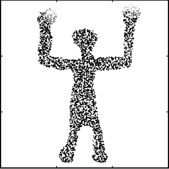
Figure 4. The geoglyph in a
square of 15 x 15 metres.
Drawing by Maarten van
Hoek.
Figura 4. El geoglifo se encuadra en un área de 15 x 15 metros.
Dibujo de
Maarten van Hoek.
|

—¿Preguntas,
comentarios? escriba a: rupestreweb@yahoogroups.com—
Cómo citar este artículo:
van Hoek, Maarten. A new (?) geoglyph in the Department of Arequipa, Peru.
Un geoglifo nuevo (?) en el departamento de Arequipa, Peru.
En Rupestreweb, http://www.rupestreweb.info/newgeoplyph.html
2013
REFERENCIAS
Hostnig, R. 2003. Arte
rupestre del Perú. Inventario Nacional. CONCYTEC, Lima, Perú.
Linares Málaga, E. 2004. Arte rupestre en Arequipa y el sur
del Perú. Editorial Nuevo Milenio, Arequipa.
Reinhard,
J. 2008. Peru -
Arequipa Region (Petroglyphs & Geoglyphs). In Picasa.
[Rupestreweb Inicio] [Introducción] [Artículos]
[Noticias] [Mapa] [Investigadores] [Publique]
|