Santa
Rita, a Petroglyph Site in the Chao Valley, Northern Peru
Maarten van Hoek. rockart@home.nl
Introduction
Santa Rita is a rock art site in the Chao Valley in
the north of Peru (Departamento de La
Libertad; Provincia de Virú; Distrito de Chao). The archaeological complex has
only recently been reported to the scientific world through excavations in the
area between 1998 and 2008. The excavations of the site - directed by Jonathan
Kent of the Metropolitan State College, Denver, USA - mainly focussed on
Pre-Columbian domestic buildings and burial sites, but as part of the general surveying
of the area several boulders with rock art have also been recorded, mainly in
the area to the NE of the excavations. The rock art site is still largely
unknown to the scientific world, but as a result of a publication by Carol
Patterson, Teresa Rosales Tham and Victor Vásquez Sánches (2010; their MS has
21 pages, numbered 1 to 21 in the PDF that I have received from Carol Patterson)
some information is now available. It is this 2010 MS - Petroglyphs of Santa Rita B Complex, Chao Valley, Peru (henceforth
referred to as the Patterson-MS) - that I will comment on, as several
conclusions and interpretations by the authors are - in my opinion -
questionable.
Site history
For matters of convenience (also
because - in general - I question the relationship between excavation remains
and nearby rock art) I distinguish the excavation site; Santa Rita B, and the rock art site; Santa Rita. The excavation site was recorded by Mercedes Cárdenas
as early as 1976, but as far as I know, no rock art had been recorded at that
occasion. Much later, in the years 1999 to 2002, the excavation team of
Jonathan Kent recorded several petroglyph boulders near the excavations in two
areas that were labelled Sector 1 and Sector 2. In the years 2000 to 2002 further
petroglyph boulders were recorded by the excavation team in another area,
Sector 3, while in 2004, Carol Patterson re-evaluated the petroglyphs located
in Sector 3 and recorded new ones within Sector 4. Unfortunately, the exact location
of those four Sectors is very confusing, as I will explain below.
Probably in 2008 a web page about
the dig was published by the California Institute for
Peruvian Studies - CIPS (Kent 2008). This web page once had a link to a photo page (that
is no longer accessible) where I found a few photos of the Santa Rita petroglyphs.
I contacted Jonathan Kent to ask for further details, but by that date no further
surveying results were available. In 2008, after an extensive email
communication initiated by Carol Patterson (who had been informed by Jonathan
Kent about my interest in Santa Rita), my wife Elles and I visited the Santa
Rita boulder field and recorded more petroglyph boulders. The following paper
is based on my 2008 survey, the 2010 Patterson-MS, the information (once)
available in the web pages about Santa Rita and the most useful information
(mainly personal records/photographs) kindly received from Carol Patterson.
Location
The Chao River, located on the western flank of
the Andean Cordillera, is one of the
driest drainages in the Peruvian Andes. Despite being located in the coastal
subtropical zone, the area is arid with scarce annual rainfall (up to 40 mm
maximum), while the average temperature is about 16° C.
Considering the dry and desolate conditions of the area today, it is clear that
severe changes have occurred on this landscape since its earliest occupation.
Nowadays this coastal area is often covered in low clouds or fog (called garúa), very occasionally producing light
rain or a fine drizzle. The soils in the valley are often rocky and low in
nutrients, and closer to the ocean the ground water is saline. All of these
factors contribute to the lack of major wildlife and sparse vegetation.
The
Santa Rita rock art site is located at the eastern end of the Chao Valley
(Figure 1), 28 km inland, about 69 km SE of the city of Trujillo, 17 km NE of
the village of Chao and on average 1.5 km NE of the hill called Cerro Santa
Rita (also known as Cerro Salital). Santa Rita is a rather remote site and it
is hard to find/reach because of a maze of narrow and winding tracks that
crisscross the valley floor. Moreover, it is situated between the convergence
of two east-west stretching valleys and thus the major dirt roads fortunately
avoid the site. Although I did not see instances of vandalism, the relatively
‘unspoilt’ area is disturbed by some recent tracks and other minor anthropic activities.
To
the north of the site is the valley of the rivers Chorobal and Tutumo, while to
the south is the valley of the Río Huamanzaña (which further east is called Río
Huaraday). To the north, south and east the site is surrounded by mountain
peaks, the most impressive and eye-catching being the triangular peak of Cerro
Colorado (906 m O.D.), 4 km to the north (Figure 2). The archaeological complex
is directly overlooked by Cerro Santa Rita to the west, while the rock art site
is found between Cerro Pucarachic(o) to the east and NE and Cerro Aguadas
Calientes to the SW (see Figure 3-top). Especially to the west are wide views (across
the flat valley floor of the Chao Valley) and, though more limited, also to the
SE (overlooking a part of the valley floor of the Huamanzaña).
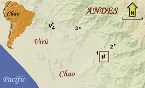 |
Figure 1. Location map (scale 5 km) of the Santa Rita petroglyph site
(marked
1 - Frame: see Figure 3-top) in the Chao Valley,
and other rock art sites in
the area: 2: Chorobal; 3: Susanga; 4: Queneto-Tomabal.
Map by Maarten van Hoek;
based on the map: La Libertad - Virú, in: Mapas Dre y UGEL.
|
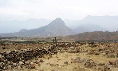 |
Figure 2. Landscape at Santa Rita, looking north towards the peak of
Cerro
Colorada with the N-S running Muralla
Pircada in the foreground.
Photograph by Maarten van Hoek.
|
Compared
with several other coastal valleys, the Chao Valley is a relatively small. The
west part of the area is characterised by several large areas of sand (dunes
and pampas) and low rocky hillocks, while the east part is rocky and
mountainous. To date most of the lands in the lower valley are being cultivated
more intensely using waters of the ‘Chavimochic’
irrigation project, which provides water for agriculture in the Chao, Virú, Moche and Chicama Valleys. Fortunately this
immense project never threatened the Santa Rita archaeological site (but has disturbed
other sites).
As
is often the case in this part of the Andes, the archaeological complex of
Santa Rita is found on an alluvial fan, which in this case stretches 2.3 km from
north to south and 1.5 km from west to east where it is blocked by a south
running ridge of Cerro Pucarachic. However, the alluvial fan actually continues
much further east. The fan gently slopes from east (at 460 m O.D. at the foot
of Cerro Pucarachic) to the NW and west (at 390 m O.D. at the modern western
edge of the uncultivated fan) measuring along the major quebrada that bisects the alluvial fan. The major concentration of
petroglyph boulders is at about 420 m, just north of the major quebrada (the only feature on the fan that
was visible with Google Earth before December 2012 - after that date a high
resolution photo became available).
Associated Archaeology
Almost as a rule in Coastal Andean
archaeology, also the rock art site of Santa Rita is not an isolated site. On
the contrary, the Chao Valley contains many prehistoric remains and of these quite
a few are from the Pre-Ceramic Period (dating before 2000 B.C). During this
early period the Chao area supported a thriving society with a mixed maritime
and terrestrial economy. The area was later occupied by people during the Formative
Period (2000 to 200 B.C.), the Early Intermediate Period, in which Moche occupied
the area, and much later by the Chimú. Nearby Cerro Santa Rita possibly fulfilled
a role similar to that of a ‘huaca’, but
instead of having a wide regional function, it was more oriented to local religion.
Other major archaeological complexes in the Chao drainage are San Jorge, El
Naranjo, Cerro La Cruz and Las Salinas de Chao.
The
north of coastal Peru is also rich in rock art sites, but I will only mention
the neighbouring rock art sites as they may be relevant in this discussion.
About 50 km to the south is Palamenco where (Formative Period) imagery similar
to that at Santa Rita has been recorded by me. Some 42 km to the east, across
rugged mountainous landscape, is the archaeological complex of La Galgada where
at least two rock art sites have been recorded (Bueno Mendoza 2006). To the
north, in the neighbouring valley of the Virú River is Tomabal and the
archaeological Temple Complex of Queneto (26 km WNW) where numerous petroglyph
boulders are found, and the Susanga Pyramid Complex (16.5 km NW) where at least
eight petroglyph boulders are known to exist (Thomas Zoubek 2012: pers. comm.).
So far only one other rock art site has been found in the Chao drainage, at 6.3
km to the NE of Santa Rita in the Chorobal Valley. It is called Quebrada de
Huanáco or just Chorobal, while Hosting (2003: 208) also mentions the geoglyphs
of two large ‘camelids’ near this site. It may be part of an inland route,
perhaps leading to the La Galgada Complex.
The Petroglyphs of Santa Rita
As
I said earlier, the petroglyphs occur in four Sectors, except for one pillar
stone (recorded by Jonathan Kent; not seen by me) with a large number of faint
cupules on its flat upper surface; many arranged in a large circle. Although
the meaning and/or function of those cupules are obscure, the whole composition
looks like a calendar stone or perhaps some recording device. This stone (which
is not necessarily a standing stone -
comparable with an erected ‘menhir’ -
as suggested in the 2010 Patterson-MS) is located near the western fringe of
the alluvial fan.
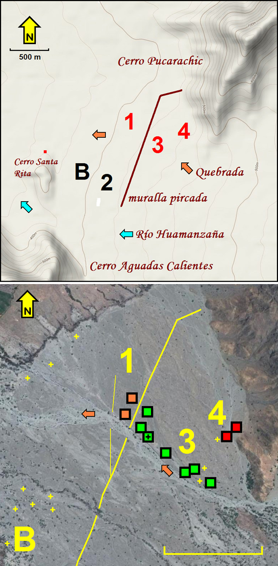
Unfortunately, a distribution map
that clearly pinpointed the location of all individual petroglyph boulders and that unequivocally indicated the limits of
the four Sectors has never been published. Moreover, the various (on-site
sketch) maps that I received from Carol Patterson indicate the four sectors at
different places. For instance, one map indicated Sector 2 (marked with ‘2’ in
Figure 3-top) just to the SE of the major dig area (marked with ‘B’ in Figure 3),
while another map had Sector 2 marked to the NE of the major dig.
|
Figure 3. Location maps of the Santa Rita petroglyph Sectors.
B: The major 1998-2008 excavation area of Santa Rita B.
1 to 4: the Petroglyph
Sectors. Drawings by Maarten van Hoek; based on
Google Earth (Maps). All scales
500 m.
|
Based on all those maps, my own short
visit and the recently published (December 2012) satellite photo in Google
Earth, I now venture to place Sector 1 (orange squares in Figure 3-bottom) about
1400 m ENE of the northern tip of Cerro Santa Rita (red square in Figure 3-top)
and Sector 2 roughly 1200 m to the SE of the northern tip of Cerro Santa Rita.
Both are located to the west of the Muralla
Pircada (to the left of the wall in Figure 3); an impressive stone wall that
crosses the alluvial fan from NNE to SSW (other walls cross the mountains to
the east). Sector 3 (green squares in Figure 3-bottom) is roughly 1600 m due east
of the northern tip of Cerro Santa Rita and Sector 4 (red squares in Figure 3-bottom)
is 1950 m ENE of the northern tip of Cerro Santa Rita, and both are to the east
of the Muralla Pircada and north of
the major quebrada.
Sector
4, surveyed for the first time by Carol Patterson in 2004, is said to be
located to the NE of Sector 3, but the factual limit between Sectors 3 and 4 is
unknown to me. Confusing is that the 2010 Patterson-MS states that a certain
petroglyph, on Boulder SRB-002 (Roca AF), is found in Sector 2 (Table 1; Row 4), while it actually is located just
east of the Muralla Pircada in Sector
3. Also confusing is that the Patterson-MS states that Sector 4 ‘encompasses
the south-eastern boundary of the flood
plain’ (2010: 3; my emphasis). This might imply that Sector 4 is found to the SE of the major quebrada and that I have seen a different Sector (5?) altogether. A
second email communication with Carol Patterson could not clarify this possible
disagreement.
It is unknown to me how many (and
which) boulders have been recorded by the excavation team of Jonathan Kent and
Carol Patterson in Sector 1, but I could find only a few petroglyph boulders north
of the major quebrada and west of the Muralla Pircada. I did not see Sector
2, but in 2000 about 21 petroglyph
boulders were recorded in a band stretching NW to SE for about 130 m, located
just north of a minor quebrada. The
petroglyphs mainly comprise minor (curvi)linear markings, at least two ‘masks’
and a few simple images of zoomorphs and anthropomorphs. Sector 2 is said to be
traversed by an ancient road (all information about Sector 2 is based on
personal communication with and information received from Carol Patterson: 2008).
I am certain that I have surveyed
Sector 1 (but only the part north of the quebrada)
and most of Sectors 3 and 4 (indicated by the red numbers in Figure 3-top), but
still several boulders escaped my attention. However, as the 2010 Patterson-MS only
proves to make reference to petroglyphs that were recorded in Sector 3 and 4,
the observations in my paper do not detract from the main thrust of my arguments.
Another
problem is that the Patterson-MS does not provide any numbering system of the
petroglyph boulders. This is unfortunate, especially as the original sketches
made during the period of 2000 to 2002 by the excavation team members provide a
(possibly provisional) labelling system, using the Spanish term Roca (rock) followed by a letter code.
Because of this general deficiency of the 2010 Patterson-MS, I hereby introduce
my own system in which every petroglyph boulder is prefixed with SRB (Santa
Rita B) followed by its own number. In case there are more decorated panels, I have
added capital letters (for instance: panel SRB-017A). Wherever possible, I will
also mention the original Roca labelling
system used by the 2000-2002 excavation team members (for instance: SRB-017 - Roca AAA).
The
boulder field of Santa Rita mainly is covered with sand, gravel and numerous small
and medium-sized boulders; only relatively few boulders exceed 3 or 4 metres.
There are two major types of rock. One type involves a light grey granite-type
of boulder that shows hardly any patination and hardly any exfoliation.
Probably because working this harder type of rock will produce petroglyphs with
hardly any contrast, this type of rock was not favoured for petroglyph
production in ancient times. I could find only one boulder of this type with a very
faint petroglyph.
The
other type of stone is (originally greenish) andesite which over time produces
an attractive deep red-brown patina on its exposed surfaces. Except for the petroglyph
mentioned above, all definite petroglyphs that I have seen appear on andesite
boulders. Unfortunately many of these andesite boulders have a tendency to severely
weather and exfoliate (a natural weathering process in which outer layers of
the stone are gradually ‘peeled off’, like an onion). Many boulders have
crumbled away almost completely and several petroglyphs have been damaged (and most
likely also destroyed) by this natural process. Moreover, many of the
petroglyphs have weathered considerably because of further weathering and (wind)
erosion.
Santa
Rita proves to be a major petroglyph site. Although the first surveys by Jonathan
Kent’s team yielded only a few petroglyph boulders, it is now one of the few
sites in Peru with more than a hundred decorated boulders. Together with the
earlier recordings (2000 to 2004) I now have a documentation of 152 boulders
with petroglyphs. Yet, it is not the intention of this paper to provide a full
inventory, but there are a few issues that I would like to address here.
Dating Issues
The first issue concerns the dating
of the Santa Rita petroglyphs in the 2010 Patterson-MS. My first concern is that
the time chart of Table 1 does not include the Early Intermediate and Late
Intermediate periods and thus incorrectly places the Moche only in the Middle
Horizon, while similarly Chimú is incorrectly placed in the Late Horizon (this
should be: Middle Horizon to Late Intermediate Period).
Moreover, the Patterson-MS ‘puts the sample size of about 75-100
petroglyphs across 4 Sectors into an estimated age chronology based on style in conjunction with visual
assessment of the age due to weathering’ (2010: 6-7; Table 1; my emphases).
Based on these two unreliable parameters the Patterson-MS argues that ‘The petroglyphs appear to range in age from
early periods that correspond to Chavín, Gallinazo era from both style and
faintness in appearance. Superimposition of later petroglyphs from Moche and
Chimú eras show up brighter and less weathered’.
I now have a twofold problem with this
statement and with the results offered in Table 1. Firstly, I am surprised by
the uncorroborated and curious interpretations of the various images and,
secondly, I am amazed by the astonishing ease with which those images have been
dated in Table 1. For instance purported ‘symbols
representing natural land or water forms’ and ‘geometric symbols’ have been classified as: Late Horizon and/or Chimú (A.D.
800 to 1400). I have no idea why the presented symbols should represent natural land or water forms’. This might
be the case, but I could not find any convincing argument; not for the
interpretation, nor for the date.
One of the justifications for a
Chimú claim is that one of the ‘geometric
symbols’, the terrace-motif, also occurs at Chan Chan, the well known Chimú
capital just NW of Trujillo. Carol Patterson does not seem to have been aware
that this specific motif also occurs in Formative Period iconographies, many
hundreds of years before Chimú (and moreover occurring in almost every Andean
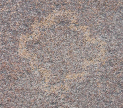
culture). The fact that this petroglyph (Figure 4) looks relatively fresher
does not have to mean anything; the petroglyph may have been re-pecked by
members of subsequent cultures who apparently still valued the symbol (perhaps
imbued with a different meaning, though).
|
Figure 4. Detail of the stepped motif on Boulder SRB-018.
Photograph
by Maarten van Hoek.
|
The only (careful) conclusion that
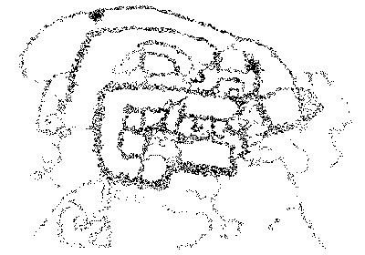
I agree with to a certain extent is that the fine ‘feline’ head (Table 1; Row 1;
first box) on Boulder SRB-006 (Roca AJ - Sector 3) is one of the (few!) images that is ‘dateable’ by its style
(Figure 5). Notably the ‘feline’ head definitely belongs to the MSC-Style; an
acronym introduced by me (Van Hoek 2011: 11) to nullify the incorrect and
therefore unwanted Chavín label that many (rock art) images in the Andes have
received. MSC-Style rock art images in this area more likely have been
manufactured by one of the Cupisnique cultures (Guañape, Sechín) during a
period of roughly 3500 B.C. to 200 B.C. (Preceramic / Formative Period). Therefore, the date (narrowed down to 700-400
B.C. - Chavín/Cupisnique - Table 1; Row 1) stated by the 2010 Patterson-MS is highly
questionable. In my opinion this ‘feline’ head is definitely not Chavín, but most likely of a (local)
Cupisnique origin (or even older). Table 1; Row 1, shows two more drawings of purported
Chavín/Cupisnique petroglyphs in Sector 3, but I could not see any stylistic
evidence to categorise these petroglyphs as Cupisnique (although they may well
be).
|
Figure 5. Detail-drawing of the MSC-Style head’ on Boulder SRB-006 (several
other petroglyphs on this panel have been omitted). Drawing by Maarten van
Hoek.
|
Following from the most uncertain
chronology as suggested in the 2010 Patterson-MS there is another conclusion
that I have serious reservations about. The 2010 Patterson-MS refers to a
hypothesis put forth by Jonathan Kent that ‘the
oldest cultures resided in the lower end of the alluvial fan and over time
settled progressively further up the fan towards the mountain base’. This
may be true; I am not in the position to doubt this. However, the 2010
Patterson-MS continues to say that ‘Similarly
with the petroglyphs, he (Jonathan Kent) has observed what appear to be very old cupules on a standing stone
near the base of the fan where the oldest features and artifacts have been
excavated, while the more recent ‘Chimú’ style petroglyphs are found midway up the fan, near and
just beyond the wall’, and that ‘The
lightest engraved or scratched glyphs are found near the base of the mountains’.
This is all very confusing (for instance: beyond;
is that west or east of the wall?) as the observations seem to suggest that the
oldest petroglyphs are found in the west part of the fan (although the cupules
have never been dated) and the more recent (Chimú?) in the east part of the fan
(near Cerro Pucarachic).
Again, the dating in Table 1 is not
based on any scientific and/or stylistic evidence and the suggested
chronological west-east flow is contradicted by the fact that the only
‘dateable’ petroglyph, on Boulder SRB-006, actually is found in the centre of the petroglyph field (93 m ESE
of the Muralla Pircada; the location
of Boulder SRB-006 is indicated with a black cross in a green square in Figure
3-bottom). In my opinion the Muralla
Pircada cannot at all be related to the general petroglyph production, or
to its content and/or distribution. Therefore it is irrelevant whether a
petroglyph is found east or west of the wall. Moreover, in 2008 I recorded a
petroglyph on Boulder SRB-058 that in my opinion shows certain MSC-Style
properties (Van Hoek 2011: Fig. 107). Importantly, Boulder SRB-058 is found in
the east part of the fan, in Sector 4, about 88 m west of the foot of Cerro
Pucarachic.
I also dispute the general attitude
to uncritically link petroglyphs with other archaeological remains nearby, like
tombs, corrals or houses. Even if an in
situ petroglyph boulder is found completely covered with smashed but in situ Chimú pottery, this fact does
not provide any firm evidence for a
Chimú origin of the petroglyphs. It
only proves that Chimú ceramics were deposited on top of a petroglyph boulder
at a certain time. Therefore, the verified occurrence of Moche and Chimú
remains in the area do not prove that the petroglyphs are indeed Moche and/or
Chimú.
Therefore, I prefer to suggest that
the whole boulder field at Santa Rita
predominantly has petroglyphs of the Early Horizon, Formative Period and
possibly even of the Pre-Ceramic Period and that only a number of petroglyphs (but I cannot determine which ones)
are of a later date (and possibly these may include images of Moche or Chimú
origin/manufacture/influence).
Interpretation
Issues
Interpreting ancient petroglyphs is
often extremely tricky. Often we see what we want to see and moreover ignore
the fact that much of the ancient rock art image(s) may have disappeared;
especially in the older images in areas with climatic circumstances that are unfavourable
regarding preservation. Furthermore, the interpretation that we offer may not
even remotely be the same as the mind-image and/or meaning of the prehistoric
manufacturer of the petroglyph we see now (I will give an example of such a
disagreement when discussing the ‘Cactus’ Issue). Therefore, in general it is
wiser to explicitly express your uncertainty regarding any interpretation and
not to jump to conclusions that - from the start - may well be questionable.
Last but not least, it would also be wise to have an open mind regarding
alternatives.
There are several interpretations in
the 2010 Patterson-MS that I seriously question, like the reading of the
petroglyphs on Boulder SRB-028 (Roca EE) in Sector 3, placed in the Late Horizon (but why?). An incomplete (!) drawing
of the petroglyphs in Table 1; Row 7, shows that the ‘star-like’ element of the
image in the first box is much fainter represented. Actually, that is not the
case. I could not see any relevant difference in patination (Figure 6). To me,
it is disturbing that the Patterson-MS (2010: 13) interprets this set of
petroglyphs as a ‘lizard snapping a fly’.
First of all, the image may be incomplete as part of the boulder has disappeared
because of exfoliation. Secondly, the lines ‘connecting’ the elements may just
accidentally connect the figures and last but not least, why not expressing
doubt or at least offering an alternative. My (jokingly - or not?)
interpretation of a ‘biomorph giving birth’ may be as valid as any other
reading. I have similar reservations regarding the ‘shells’ interpretation (Row
6) and the ‘open mouth or tail’ readings (Row 3). The former could well be
interpreted as a ‘hand’ motif and although the latter instances may indeed concern
images in which biomorphs may have ‘open tails or mouths’ because of a certain
graphical convention (like numerous examples at Toro Muerto in the south of
Peru), equally parts of the design may have weathered off. Yet, two specific interpretations
need to be more fully discussed.
|
Figure 6. The petroglyphs on Boulder SRB-028.
Photograph by Maarten
van Hoek.
|
The ‘Cactus’
Issue
Interestingly, the 2010
Patterson-MS interprets a number of images (Table 1; Row 5) as ‘fully outlined (…. missing?) representing San Pedro cactus and flower’,
while the caption to her Fig. 13D even reads: ‘petroglyph of San Pedro
Cactus with possible snails on it’
(I will return to this ‘snail’ issue later on). According to the 2010
Patterson-MS ‘The cactus motif is the
most prevalent motifs of all the petroglyph panels found in this survey’. However,
there seem to be two different types of purported ‘cactus’ representations:
roughly circular motifs (represented at Santa Rita with at least 5 motifs) and
oblong elements (with at least 20 examples). Indeed, the motifs in question are
indeed found on several boulders, but I doubt whether they are the most
prevalent motif at Santa Rita (this may well be the reptile imagery: lizards
and snakes).
Although I cannot prove that the cactus-interpretation is
not correct, I would like to offer a more plausible alternative. Notably, it
struck me that several of the purported ‘cactus’ motifs prove to have five small ‘elements’ at the top. These
five elements could well represent ‘toes’
and thus the motif may well (or rather, better) be observed as a ‘foot’ image (in some cases even as a ‘sandal’).
There are several other arguments
that underscore the ‘foot’ interpretation. Firstly, Andean iconography is not
always concerned with representing the factual number of digits. Feet and hands
often have four, even three or six digits. Thus, the ‘cactus’ motifs with less
or more than five digits may still represent ‘hands’ or ‘feet’. An argument in
favour of the ‘cactus’ interpretation is that they almost invariably have been
depicted in a more or less vertical position, with the ‘toes’ on top. However, in
rock art also ‘feet’ images are almost always found oriented vertically.
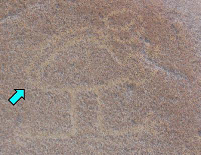
However, one ‘foot’ petroglyph, on Boulder SRB-038 (Figure 7), is clearly
oriented horizontally (although the rather small boulder may once have been disturbed
and dislocated). Moreover, the ‘foot’ clearly shows five toes in such a way
that it proves to be a ‘left foot’ (length about 22 cm). It seems to be
superimposed on earlier (?) and clearly much fainter petroglyphs. Instances of
palimpsest may also explain the interpretation of an image as a ‘petroglyph
of San Pedro Cactus with possible snails on it’; the ‘snails’ being (parts of) earlier or later petroglyphs.
|
Figure 7. Close-up of the ‘foot’ petroglyph on Boulder SRB-038.
Photograph
by Maarten van Hoek.
|
There are other arguments in favour
of the ‘foot’ interpretation. In a few cases examples of two ‘feet’ are found
on a panel; either in a line or next to each other. The former configuration
(only convincingly found on Boulder SRB-027A - Roca J) might be
explained as symbolising a person ‘walking’; possibly even as following a (ritual)
route. However, just above the two ‘feet’ are two circles, each with five
lines. These may symbolise the ‘hands’ or ‘handprints’ (of the same person?).
The fact that the 2010 Patterson-MS offers a drawing (Table 1; Row 5; second
box) showing six ‘digits’ is not relevant as explained above. Moreover,
scanning the photographic record of this boulder (Figure 8), I could trace only
five ‘digits’ at each ‘hand’. It is moreover remarkable that the petroglyphs on
panel SRB-027A have been ‘dated’ to the ‘Middle Horizon’ in the 2010
Patterson-MS (Table 1; Row 5; second box), while on the same boulder adjacent panel
SRB-027B (also showing one - possible - ‘foot’ petroglyph) has been ascribed to
the ‘Early Horizon’ (Table 1; Row 1; second box). Of course this is possible,
but I wonder on what grounds these chronological decisions and distinctions have
been made.
|
Figure 8. The petroglyphs on Panel SRB-027A.
Photograph by Maarten van
Hoek.
|
O
nly a few metres further east of
Boulder SRB-027 is Boulder SRB-029 (Roca ii). On the sloping NNW surface (panel SRB-029A) is one distinct ‘foot’
petroglyph and - much weathered and thus very doubtful - two more examples. On
the vertical SSE facing side (panel SRB-029B) the 2010 Patterson-MS (Table 1;
Row 5; first box) shows three ‘foot’ petroglyphs of differing sizes, although
only two certain ‘foot’ petroglyphs are now visible. Despite the differing
sizes they might have been intended to form a matching pair.
A more convincing (though much
weathered) ‘pair of feet’ concerns the petroglyphs on Boulder SRB-063; actually
it is the first petroglyph panel that I noticed at Santa Rita (in Sector 1 and
about 50 m west of the great wall). It clearly is a ‘pair of feet’, overlooking
a narrow (ancient?) path (Figure 9). In this case the pair indeed seems to
depict a matching left and a right ‘foot’, each with five dots for ‘toes’.
|
Figure 9. The ‘feet’ petroglyphs on Boulder SRB-063
(left of an ancient
[?] path).
Photograph by Maarten van Hoek.
|
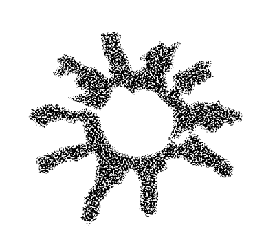
The 2010 Patterson-MS (Table 1; Row
5; third box) also includes a motif (the only petroglyph on Boulder SRB-075 -
not seen by me) comprising a circular groove with ten short grooves emerging all
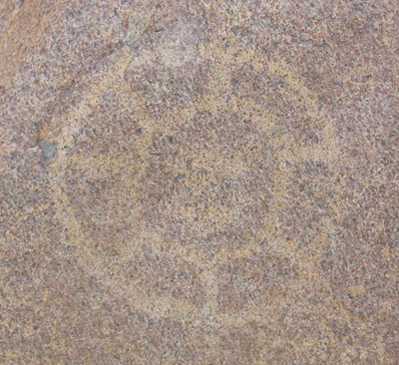
around from it, thus creating a kind of ‘solar’ or ‘stellar’ motif (Figure 10).
Remarkably, this ‘solar’ motif is compared in Fig. 12 of the 2010 Patterson-MS
with a photo (previously published in Wikepedia,
though this source has not been mentioned) showing sections/slices of the
actual San Pedro cactus. Again, I prefer to read this motif differently as well.
To me it is more plausible that it is a ‘solar’ symbol; a rather common motif
in Andean rock art. Equally, it could well represent something else. Moreover,
the six-pointed slices of the cactus in Fig. 12 of the 2010 Patterson-MS have
much more in common with the six-pointed stone mace head that was found in the
area (information based on a photo once accessible in the 2008 CIPS internet page).
Images possibly representing mace heads are very rare in Andean rock art (I
know of only a few ‘convincing’ examples, at Yonán in Jequetepeque, while
another occurs in the Virú Valley).
|
Figure 10. The petroglyph on Boulder SRB-075. Drawing by Maarten van
Hoek, based on a photograph from the personal collection of Carol Patterson
(2009: pers. com.).
|
Fig. 12 in the 2010 Patterson-MS
shows another petroglyph (again the only motif on this stone; Boulder SRB-040 -
not seen by me) comprising a circular groove with ten short grooves emerging
from the upper arc only, thus giving the impression of a ‘hand with ten
fingers’. This petroglyph is linked in the photograph with a cactus that
happens to grow behind the boulder (in 2004). First of all, that specific
cactus probably was not there when the petroglyph was made and even if another
cactus was found nearby in ancient times, the motif not necessarily has
anything to do with the actual cactus (not even while the top of the cactus
somewhat resembles the petroglyph).
Finally, I do not see any reason to
date those supposed ‘cactus’ petroglyphs (that I prefer to interpret as ‘feet’) only from the ‘Middle Horizon’,
especially as the 2010 Patterson-MS contradicts this by stating that ‘The use of the San Pedro cactus has roots in
the Chavín culture’, while simultaneously comparing the motif with earlier Cupisnique pottery (Fig. 13A). I
categorically reject any unequivocal Chavín relationship for any of the
petroglyphs at Santa Rita. I again prefer to date most of the Santa Rita
petroglyphs to the local Cupisnique
(or earlier) cultures, while later petroglyph influences are in my opinion scarcer.
The ‘Snail’
Issue
One of the purported ‘cactus’
petroglyphs was said to have possible snails on it (Patterson-MS 2010: Fig.
13D). The motif - that I prefer to read as a ‘foot’, despite the fact that the
drawing in the Patterson-MS only shows four ‘digits’ - has some roughly
circular internal markings. Although I cannot offer any proof that would
contradict the ‘snail’ interpretation, I cannot unconditionally accept that
those small, amorphous markings are indeed depictions of ‘snails’.
Even more controversial - and in my
opinion unacceptable - are the claims in the Patterson-MS (2010: 14) that ‘Depictions of land snails are found both in
profile and cross section on a boulder in Sector 3’, referring to the
petroglyphs on Boulder SRB-017 (Roca AAA). Even though the caption to Fig. 14 reads ‘A boulder possibly depicting
a snail and its chambered shell (A), and a living snail (B) with a close up
drawing of the snail (C)’, the
word ‘possibly’ is too unconvincing. The Patterson-MS also states
that ‘The petroglyphs on this boulder
show two perspectives of the snail. The brighter, segmented circle motif is of
the snail shell in cross section showing the chambers. The corresponding line
drawing is of a snail in profile with the over-arching shell that curls, the
antenna on the head above the eye, and a ‘foot’ that reaches out in opposite
directions’. All these claims will
be commented on here.
First of
all I dare any-one to make a cross section of the fragile land snail from the
Santa Rita area and to compare it with the large circular ‘wheel’ motif on
panel SRB-017B (Figure 11). I am pretty sure that it will be different to the
petroglyph. And even if one is able to create a match, this not at all
proves that the ‘wheel’ motif indeed represents a cross section of a snail. Interestingly,
panel SRB-017A (the other side of the same boulder) also has a (much fainter)
‘wheel’ motif that has not been taken into account in the discussion. Moreover,
similar ‘wheel’ motifs occur at other Andean rock art sites, where they are
found associated with other designs and/or biomorphs. Finally, snail-shells
(molluscs) do not have ‘chambers’ like prehistoric ammonites (squids).
|
Figure 11. The ‘wheel’ petroglyph on Panel SRB-017B.
Photograph by
Maarten van Hoek.
|
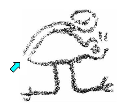
More disturbing is the
interpretation of the zoomorphic petroglyph on panel SRB-017A (Figure 12), which is claimed to
represent a ‘snail shown in profile’
in Fig. 16 of the 2010 Patterson-MS. The 2010 Patterson-MS offers three lines
of ‘evidence’ for this claim, but all three substantiations are - to me -
highly disputable and will be commented on.
|
Figure 12. The zoomorphic petroglyph on Panel SRB-017A.
Photograph by
Maarten van Hoek
|
Firstly, there is the ‘arc over the body to represent the shell
that curls upwards’. To me this feature simply is the curled tail of the
zoomorph; a fairly common position and shape of tails in zoomorphic figures in
rock art images in this part of the Andes. Indeed, the groove arcs over the
body, but it is not a line that is
separated from the body. Only seemingly this ‘tail’ is detached from the rear
end of the body. Notably, the very first bit of the tail (where it in fact is
attached to the back of the zoomorph) is more weathered and thus fainter.
Probably for that reason a small part of the tail has not been drawn in the black-and-white drawing of the Fig. 16 in the
2010 Patterson-MS (Figure 13: blue
arrow). Another argument against the ‘arc representing a shell of a snail’ is that a number of petroglyphs
of quadrupeds at Toro Muerto in the far south of Peru also have an ‘arc’,
without giving any impression of representing or even symbolising a ‘snail’.
|
Figure 13. The purported ‘snail’ petroglyph on Panel SRB-017A. Drawing
by Carol Patterson (2010: Fig 16); the blue arrow has been added by the author
in comparison with Figure 12.
|
The second argument raised in the
2010 Patterson-MS to classify the zoomorph as a ‘snail’ is the fact that the
‘head’ has two short ‘antennae’. Indeed, snails often have those two appendages, but so do other species. In
my opinion the two appendages simply represent the simplified ‘ears’ of the
undeterminable zoomorph (a viscacha, perhaps?).
The third contention focuses on the
‘unusual’ position of the ‘legs’ and especially of the two ‘feet’. Notably, the
Patterson-MS describes a specific aspect of the zoomorph a follows: ‘one foot [is] leading forward and one foot leading backward’ (2010: 14). First
of all, snails do not have legs and feet (actually, I could now rest my case,
but Andean iconography may again surprise us). More convincingly contradicting
the ‘snail’ interpretation regarding the opposed ‘feet’ is the fact that other,
also determinable, species of animals
have been depicted in profile in Andean iconographies with ‘feet’ pointing in
opposite directions.
Richard Burger illustrates a Chavín
gold ‘feline’ (1995: Fig. 221) that clearly shows the same position of the two
feet/claws, which proves that the custom to occasionally place ‘feet’ in an
opposing configuration occurred as early as the Early Horizon and thus most
likely as well in the Formative Period (or even earlier).
In the rock art of the Andes images
of laterally depicted zoomorphs with ‘opposed feet’ also sporadically occur and
some of them look very much like the Santa Rita example. Several remarkable
analogies are found at one of the Motocachy Pampa petroglyph sites, NW of the
town of Moro in the Nepeña Valley, recorded by Donald Proulx in 1971. Boulders MP1-002,
MP1-003 and MP1-006 (Figure 14) feature zoomorphs with ‘opposed feet’, that are
more or less similar to the Santa Rita zoomorph. The fact that the ‘tail-ends’
spirals downwards is irrelevant in this respect. Interestingly, also this site
(about 75 km SE of Santa Rita) has at least one definite MSC-Style ‘face’
petroglyph, on Boulder MP1-004 (Van Hoek 2011: Fig. 118).
|
Figure 14. Petroglyphs on Boulder MP1-006 at Motocachy Pampa - Site 1,
Nepeña. Photograph from the personal collection of Donald Proulx (2009: pers.
com.).
|
Another petroglyph that has much in
common with the Santa Rita ‘snail’ occurs on Boulder VAG-004 at El Vagón-2 in
Moche (about 56 km NW of Santa Rita). I discovered this example (Figure 15) in 2008. If there would be an applicant in Andean
rock art for representing a ‘snail’, this petroglyph would possibly be a better
candidate. A short distance further south is Alto de la Guitarra with a few petroglyphs
of zoomorphs with ‘opposed feet’.
|
Figure 15. Petroglyph on Boulder VAG-004 at El Vagón-2, Moche.
Drawing by Maarten van Hoek.
|
In the Chicama drainage (more than
100 km NW of Santa Rita) Daniel Castillo Benites reported several petroglyphs
of zoomorphs with ‘opposed feet’, for instance the ‘squirrel’ (ardilla de los algarrobales) at Quebrada
la Mónica (2006: Fig. 43). At Cerro Negro, also in Chicama, I noticed several
petroglyphs of profile zoomorphs with ‘opposed feet’ (possibly all ‘monkeys’).
At La Galgada (42 km east) are two
petroglyphs of ‘felines’ (?) that may be regarded to have ‘opposed feet’ (Bueno
Mendoza 2006: Foto 2 and Lámina IV). At Yonán in Jequetepeque (about
150 km NW of Santa Rita) several panels have zoomorphic petroglyphs with
‘opposed feet (for example YON-015, YON-038B, YON-040A and YON-048). Panel
YON-026A even has a ‘feline’ petroglyph with ‘opposed feet’. At nearby Quebrada
de Felino (or Pampa de Mosquitos) two petroglyphs clearly depict zoomorphs with
‘opposed feet’, one probably a Formative Period ‘feline’ (Pimentel 1986: Figs
81.1 and 82.1). Also at Palamenco (about 50 km SE of Santa Rita), a small,
fully pecked zoomorph with distinctly ‘opposed feet’ occurs, on Boulder
PAL-062A. Interestingly, Alto de la Guitarra, Yonán, Quebrada de Felino,
Motocachy Pampa and Palamenco all have MSC-Style imagery from the Formative
Period, like Santa Rita.
More
than 557 km SE of Santa Rita, Víctor Salvo (2011) reported a similar zoomorph
with ‘opposed feet’ on the Gran Piedra
Sagrada near Lunahuaná in Cañete (Lima). The zoomorph (Figure 16) has been interpreted as a
‘fox’ (el zorro lunar) by its
discoverer, who moreover identified the zoomorph with Moche iconography
(despite the fact that Moche supremacy never reached Cañete). A short distance
further south in the same area, a painting on a ceramic - possibly belonging to
the Chincha culture - clearly shows a fully profile zoomorph with opposed feet (source - fuente).
Even as far south as Toro Muerto and Alto de Pitis (both sites located at about
1070 km SE of Santa Rita) several petroglyphs of quadrupeds with ‘opposed feet’
(probably ‘camelids’) have been recorded by me, for instance at Toro Muerto on
Boulders Da-003, Da-044 Dx-082, and especially on Da-042 (Figure 17), and at Alto de Pitis on Boulder AP3-132 (Figure 18). All these analogies regarding the ‘opposed feet’
demonstrate that the property of having ‘opposed feet’ is no indication of animal species and thus also the ‘snail’
interpretation must be rejected.
|
Figure 16. Petroglyph on the Gran
Piedra Sagrada, Lunahuaná, Cañete.
Drawing by Maarten van Hoek, based on a
photograph by Víctor Salvo (2011: Fig. 1).
|
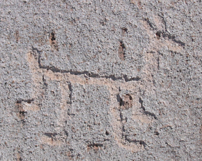 |
Figure 17. Petroglyph on Boulder Da-042 at Toro Muerto, Majes
(the two
larger legs may have been added at a later stage).
Photograph by Maarten van
Hoek.
|
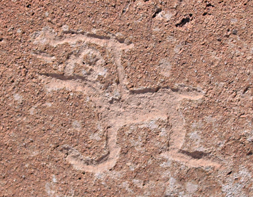 |
Figure 18. Petroglyph on Boulder AP3-132 at Alto de Pitis, Majes.
Photograph by Maarten van Hoek.
|
Finally, regarding the Boulder
SRB-017 petroglyphs, the 2010 Patterson-MS claims that ‘These [snail] petroglyphs
illustrate an evolved stage of picture-writing characteristic of the period
around A.D. 1300 to 1400’, and places them in the ‘Late Horizon’ (Table 1; Row
8; second box), while the 2010 Patterson-MS simultaneously claims that the ‘underlying glyphs, that are very faint’
have been assigned to the ‘Early Horizon’
- Salinar culture - 400 to 200 B.C. (Table 1; Row 2; first box). This
implies a huge chronological discrepancy, which is inexplicable, because it is
based on what evidence?
The Patterson-MS however ignores
the possibility that a collection of motifs on a rock panel made by one culture may have been executed using
different techniques (resulting in very superficial to more deeply pecked
motifs). Even a ‘small’ time span of one to two hundreds of years between the
manufacturing of two layers of petroglyphs on one panel by one culture may result in the combination of fainter and brighter (and
different!) motifs that we see on one panel nowadays. And again, also ignored
is the possibility that certain motifs were (partially) re-pecked in (much) later
eras by other cultures.
Personally I do not believe in the picture-writing theory (which, in the
case of the 2010 Patterson-MS, departs from the unverified assumption that the
petroglyphs indeed depict ‘snails’, which I proved to be highly questionable)
and moreover, I do not see any reason to claim that this picture-writing would
be ‘characteristic of the period around
A.D. 1300 to 1400’. Why not earlier? To me all those claims are unsupported
and thus unscientific remarks.
Conclusions
In general I applaud every serious
attempt at interpreting rock art motifs. However, in every case any
interpretation must be credible and should be substantiated by acceptable,
reliable and verifiable arguments. In my opinion absolute statements (those offering no room for alternatives) should
be avoided. In most cases we simply do not know what a rock art motif
exemplifies, not to mention the fact that we hardly ever will understand the
exact meaning ‘behind’ the visible motif as experienced and ‘seen’ by the
prehistoric manufacturer. Every rock art researcher should have an ‘open mind’
and preferably express the fact (in whatever way) that he or she is often only
subjectively interpreting, which means that hardly anything is certain.
In the case of the general
chronology suggested for the Santa Rita petroglyph record, I have demonstrated
that the results in the 2010 Patterson-MS are highly questionable. So far none of the petroglyphs at Santa Rita
yielded an absolute date. Only a few images can roughly be dated to the Early
Horizon and/or Formative Period. This is dating is only based on the graphical
analogies with images in dateable structures. The remainder is (most)
uncertain. This uncertainty should have been expressed.
In case of the interpretations in
the 2010 Patterson-MS of a number of motifs (especially the ‘cactus’ and the
‘snail’ explanation) I have demonstrated that alternative readings are available
(respectively ‘feet’ and ‘viscacha’), without claiming however that my readings
are the only correct interpretations.
Acknowledgements
This paper could not have been
written without the help of several people. In this respect I would like to especially
thank Carol Patterson for her personal and magnanimous help by making specific
information on Santa Rita rock art accessible to me. She generously provided me
with detailed information on Santa Rita, including many drawings and unpublished
photographs from her personal records, some of which has been used in this
paper. I am also grateful to Carol for emailing me a digital copy of the 2010
Patterson-MS. I am also indebted to Professor Donald Proulx from the University
of Massachusetts for sharing
with me photographs of Nepeña rock art and informing me of the Motocachy
petroglyph complex. I am also grateful to Dr Thomas Zoubek for his information
on the Susanga petroglyphs. Last but not least, I would like to thank my wife
Elles for her support as usual and for sheltering me with an umbrella against
the (unanticipated) light rain we had at Santa Rita.

—¿Preguntas,
comentarios? escriba a: rupestreweb@yahoogroups.com—
Cómo citar este artículo:
van Hoek, Maarten. Santa Rita, a Petroglyph Site in the Chao Valley, Northern Peru.
En Rupestreweb, http://www.rupestreweb.info/santarita.html
2013
BIBLIOGRAFÍA
(References in blue are links to
the sources as accessible on the internet in 2012).
Burger, R.
L. 1995. Chavín and the origins of Andean
civilization. Thames and Hudson, London.
Castillo Benites, D. S. 2006. Arte Rupestre en la Cuenca del Río Chicama. Ediciones SIAN,
Arqueología / 4. Trujillo, Perú.
Bueno Mendoza, A. 2006. Petroglifos en la quebrada Morín y La Galgada: de
los textos gráficos al mito etiológico. Investigaciones Sociales 67: Arqueología. Año X; N° 17; pp. 67 - 90. UNMSM - IIHS, Lima.
Kent.
J. 2008. Archaeological Investigations at Santa Rita
B, Chao Valley, Northern Coast. Dig Peru: Archaeological Field Expedition to
Northern Peru (1998-2008). In CIPS. The web page with the Project Photos - http://www.cipstudies.org/photos.htm -
is no longer accessible.
Pimentel, V. 1986. Petroglifos
en el Valle Medio y Bajo de Jequepeteque, Norte del Perú. Bonn, Alemania. Verlag C. H. Beck, München.
Salvo V. 2011.
Misterios de la ‘Piedra Sagrada’. In: Petrogliflos
en Lunahuaná!!, importante anuncio. Lunahuaná.
The 2010 Patterson-MS: Patterson, C.,
T. Rosales Tham & V. Vásquez Sánchez. 2010. Petroglyphs of the Santa
Rita B Complex, Chao Valley, Peru. Available on the internet (unfortunately only via Facebook).
Van Hoek, M. 2011a. The Chavín Controversy - Rock Art from the Andean Formative period.
Privately Published using the BLURB Creative
Publishing Service. Oisterwijk, The Netherlands.
|