The
Motocachy Pampa Disaster:
A Tale of
Neglect of Rock Art
Maarten van Hoek. rockart@home.nl
Introduction
Nowadays many organisations and individuals are
deeply committed preserving their cultural heritage for future generations.
Museums have been built to display valuable items and specific areas are
officially protected. For instance, the UNESCO’s World Heritage List
now registers almost a thousand properties. Regrettably it seems that rock art
- a very important part of the global cultural heritage - is often considered
not to be that important. For instance, only two percent of the World Heritage
List comprises rock art sites (not counting rock art sites that happen to be
included in National Parks etc). Regrettably 44 of those properties are in
danger, which proves that being on the World Heritage List is not a guarantee
that nothing will endanger the site. Fortunately all rock art sites on the
UNESCO list are registered as ‘not endangered’. Yet, many rock art sites
worldwide are in constant and increasing danger of being severely damaged or
even destroyed. Therefore rock art protection is more than essential nowadays.
This paper discusses a specific type of preserving rock art. Because the
situation in the Andes of South America is best known to me at the moment, I
will focus the discussion mainly on rock art sites in the deserts of western
Peru. However, the outcome of this paper applies to any (Latin American)
country with rock art (for instance Argentina, Brazil, Bolivia, Chile (where the Dakar
Rally already caused damage to ancient
geoglyphs), Colombia, Venezuela and Mexico).
An example in Chile (see Fig. 4) shows that vandalism is not only a recent problem but that it often
started quite long ago (in this Chilean case at A.D. 1836). Sadly the damage
continues and increases, because any damage
too often triggers further damage.
Peru is said to be one of the 15
countries richest in rock art. Having visited Peru many times I can only confirm that the amount
of rock art in this country is enormous and that it is moreover enormously
important. Besides the numerous archaeological remains in the Andes, rock art
is a most valuable part of the legacy of the ancient Andeans who once inhabited
this rugged and beautiful area. This graphical legacy is most precious. In
fact, one cannot ever put a price on the rich gamut of rock art in this
mountainous and desert area; not even on one single rock art panel.
However, during each visit to Peru
my wife Elles and I were shocked to see the ongoing damaging and destruction of
rock art and rock art sites. In this respect it is a disadvantage that Peru is
a very large and rugged country and that rock art is often found in remote
places. In most cases there is no supervision at all and, moreover, it is
(generally and globally) a Sisyphus job to teach the local people to respect
their cultural legacy. We have seen local people rubbing petroglyph panels with
sand in order ‘to make them better
visible’, and even when we explained that this was a most unwanted
practice, they still continued to do so. Although some formal effort is done to
instruct tourists to rock art sites not to touch the rock art and not to
interfere in any way with the rock art site (or any archaeological site for
that matter), the education of the local communities often seems to be ignored.
Also unfortunate is the fact that
in many Peruvian web sites, rock art sites are often promoted as tourist attractions (see also Atractivos
Turísticos and Turismo
Arqueológico [notice
the chalked/painted in images]), probably in the hope that the area will
receive more (foreign?) tourists. In one case I even found a photo on the
internet of a petroglyph
boulder ‘made attractive’ by a lady who was
sitting on top of it; like on a new car in a showroom. However, I fear that
adequate measurements to protect the rock art and to educate both the local
population and the tourists will be no part of such tourist campaigns.
Although I cannot prove that local
people are more destructive than tourists, I nevertheless claim that the
biggest damage and destruction of rock art in Peru is often caused by local
people and authorities. Therefore, one of the major goals of any official rock
art organisation should be the education of people and a strict vigilance
towards the future activities of local, regional, and national authorities.
Yet there is another form of
neglect, which, in combination with the problems described above, is also part
of the general disaster. Notably, too often it proves that academic scientists
ignore rock art during their researches. Systematic surveys recording every bit
of rock art of a certain site/area are rare in Andean archaeology, although
there are a number of exceptions that offer a complete record of all (known)
rock art panels of a site (Van Hoek 2011a) or even a larger area. Admirable
examples of surveys of larger areas are the excellent Lower Nasca River Rock
Art Inventory (central Peru) by Ana Nieves (2007) and the most extensive
Inventory of the Rock Art of the Codpa Valley in northern Chile (CIHDE 2012).
However, too many times archaeological surveys and reports prove to have
excluded rock art manifestations from their recordings, while in my opinion it
is the responsibility of every archaeologist to carefully and meticulously
record and report rock art as well. Of course this statement needs to be
verified. In this respect the neglect during the Beringa Project is most
illustrative.
The Beringa project
The Beringa
Project (PDF), directed by Tiffiny Tung, Associate Professor of Anthropology of the Department of Anthropology, Vanderbilt University,
Nashville, USA, involved the scientific excavation of Beringa, an
archaeological site in the valley of the Río Majes, which is located in
the Department of Arequipa, southern Peru. Excavations of a small room (Unit 2
in Sector A) in the Pre-Columbian settlement of Beringa produced, among several
other items, three ‘placas
pintadas’
(painted Votive Stones) and a ‘camelid’ petroglyph on the internal surface of a
foundation stone. According to Dr. Tung, the leading archaeologist of the team
that was excavating the site, no petroglyphs were found in other structures,
but ‘they were observed on large boulders
surrounding the site’ (2007: 258). I was most interested to learn more
about those petroglyphs and wrote to Dr. Tung in 2012.
Unfortunately
Dr. Tung was not able to help me by providing any additional information about
the style and content of the rock art at Beringa. She wrote to me that she did not
have any photos of the petroglyphs at Beringa; not even of the ‘camelid’
petroglyph, because that was not her primary area of research (Tung, July 2012:
pers. comm.). To me this sounds very strange because in her paper she writes
that numerous photos were taken
throughout the process of surface collection and excavation’ (Tung 2007: 269). Why
then exclude such an important discovery from being recorded/photographed? She
moreover writes: ‘Using a theodolite, the mapping team documented all visible architectural features,
trash berms, tomb openings, looters’ pits, petroglyphs,
surface collection units, excavation units, and the edge of the site as
demarcated by a steep escarpment along its western edge’ (Tung 2007: 269;
my emphases in bold print). I now seriously wonder why no photographs of the
Beringa petroglyphs are available. Consequently I asked Augusto Cardona Rosas,
director of CIARQ,
Arequipa, who visited the Beringa Project, and Bruce Owen (Beringa Project Ceramicist) if they had taken any
photographs of the petroglyphs. Via email they answered me that they as well
did not have any photographs of the petroglyphs at Beringa (Augusto Cardona
Rosas and Bruce Owen 2012: pers. comm.).
To
me it sounds very strange that an authorised, scientific, archaeological survey
would not ([photo]graphically) record all items related to the investigations;
thus including all rock art manifestations (why only illustrating and
describing ‘placas pintadas’ [Tung
2007b: Fig 9] and not the petroglyphs?). The presence of rock art discovered
during such an important excavation may be of crucial importance (sensu stricto and sensu lato) in understanding the whole archaeology of the area.
The
inadequate procedure at Beringa indeed proves that rock art is often neglected
in archaeology. But it also proves that, unfortunately, professional and
academic researchers do not always photographically record everything relevant.
I therefore recommend that every official, scientific archaeological
survey/excavation records also rock art in every possible way
(photographically, textually and cartographically). Besides the fact that it is
only scientifically correct to record everything relevant during an excavation,
this plea also has a specific reason. Notably, every sincere archaeologist will
be aware of the vulnerability and volatility of prehistoric remains. Often
remains only are ephemeral; even when it concerns remains of solid stone. In
addition, most rock art is not guarded against destruction. One of the means to
‘rescue’ rock art is to be certain that a complete photographic record has been
made. It demonstrates that making such photographic records is critically necessary, not only in Peru but elsewhere in the
world.
Destruction
of Rock Art
Although most rock art in the Andes
still is unscathed, especially anthropic destruction is increasing rapidly.
Importantly, all damage to a rock art panel, no matter
how ‘minor’, is completely unacceptable and should be avoided and prevented at
all cost. Unfortunately, there are numerous instances of anthropic damage to
rock art sites in the Andes, ranging from small scale theft and vandalism to
large scale and even authorised destruction. This is often carried out without
having the intention to destroy rock art; it ‘simply’ is collateral damage). In the following paragraphs I will review
several instances of rock art destruction in Peru to show how diverse it can be.
In 2004 I found two large boulders
at Alto de la Guitarra in the north of Peru to have been heavily
vandalised (see Fig. 5) with paint. This paint was brought to this remote
site on purpose after a long and
arduous walk of at least three hours (single way!). This is not the work of
tourists (who are unaware of the situation and usually do not carry paint) and
I also exclude enthusiastic rock art researchers who are deeply concerned about
protecting rock art. Most likely this instance of despicable vandalism has been
carried out by local people. The same goes for a large petroglyph panel at
‘nearby’ Queneto.
Every genuine rock art researcher will be shocked to see the sheer numbers of
people climbing (and thus damaging) the rock art panels of Yonán,
an important (unsupervised but markedly signposted) rock art site in the north
of Peru (several panels at this impressive site were already vandalised in
2004). Most rock art at the site of Cerro San Simón has already disappeared.
The instances of vandalism, destruction and robbery at the biggest petroglyph
field of Peru, Toro
Muerto in the south of Peru, are numerous, despite many publications on the internet.
We noticed that Peru is really
improving its infrastructure. Many roads are being tarred and bridges are
built. This often comes at a price. Petroglyph boulders from Cerro Garraspiña in
the north of Peru were destroyed in 2007 and the stones were used to build a
bridge across the nearby river Chancay. Frequently roads have been constructed
indiscriminately, often bordering very closely rock art sites (for instance
Cerro Mulato), or even cutting right through petroglyph fields. This happened
for instance at Huaca Blanca and Pocos in the north of Peru, at Muralla in central Peru and at San Antonio,
La Barranca, Sotillo, Alto
de Pitis, Cerro Pano (Van Hoek 2011a) and Miculla, all in the south of Peru. Unfortunately those
roads also facilitate the stealing of petroglyph boulders. But also less
accessible sites suffer from robbery. In 2004 I
noticed attempts of robbing petroglyphs from a boulder at Checta (pause this You Tube
video at 3.10 minutes); a site easily accessible from Lima but involving a
steep climb from the road, much visited and therefore heavily vandalised in
general. Also at Toro
Muerto in the south of Peru several petroglyph boulders have been
(partially) robbed or damaged in order to steal petroglyphs. Being close to a
road also increases the risk of being vandalised. The petroglyph panels of
Sotillo on the Panamericana Sur Highway vandalised with paint and scratches and the petroglyph boulder at Pay
Pay on the road to Cajamarca in northern Peru used for posters are sad
examples.
Another threat is the construction
of new buildings on top of rock art sites. When I recorded petroglyphs at
Muralla in the Pisco Valley in 2004 (Van Hoek 2005: Fig. 1) there were no
buildings at or near this small site. The Google Earth satellite photo of 2009
clearly shows that a building had been constructed right on top of the site
(13°35'32.69"S and 75°33'16.92"W). In 2004 several buildings already
existed on top and very near the site of Pakra, a petroglyph site only 450 m
NNE of Muralla, but the difference between the 2002 and 2009 photos in Google
Earth is most disturbing.
One effect of publication on the Internet (including
the numerous Panoramia photos accessible
via Google Earth) is that people know of rock art sites and are going to visit
them. This issue raises the well-known problem: reveal the location
of an archaeological site or not? As a scientist I prefer to include the
location; it is part of the investigation. The argument that one can always ask
the author the location is meagre. In the past 35 years I was only very sporadically asked to provide information about the location of a rock art site and
in many cases it is not even possible to ask the (late) author a question.
Another problem is that there is already so much detailed information about
rock art locations available on the internet (for instance Huancor in central
Peru and a newly discovered site in Brazil are found on web sites along with Google Earth maps) or in scientific publications
(often available as PDF [see Imagen 7] on the internet) that
it is much wiser to educate people than to (seemingly) withhold information.
Indeed, vandalism is also triggered
by publications on the Internet (although this certainly not will have been the
intention of the people who have put the information on the WWW). For instance,
at Cerro Saltur a wonderful and unique petroglyph of a large bird has
shamefully been painted on by locals from the nearby village. This petroglyph was reported on the internet
in 2008 by Elmer
Fernández Gastelo who very likely never would have thought that within a
year or two pupils from a local school would destroy this magnificent image
(Figure 1; showing a detail of the vandalism). Even the respectful text of his
web page: Petroglifo "El Cóndor" ubicado en el cerro Saltur a unos
200 m de altura, la imagen representa a uno de los principales dioses de una de
las principales altas culturas peruanas", did not stop the vandals
(although those vandals may have heard about the petroglyph locally, not via
the internet). The boulder is difficult to reach. It is not located at 200 m
O.D., but at about 305 m and - from the village of Saltur (at 72 m) - it took
me about an hour to reach the site via a narrow and steep, rocky path. The
vandals therefore must have taken paint up to the site with the deliberate
intention to vandalise it.
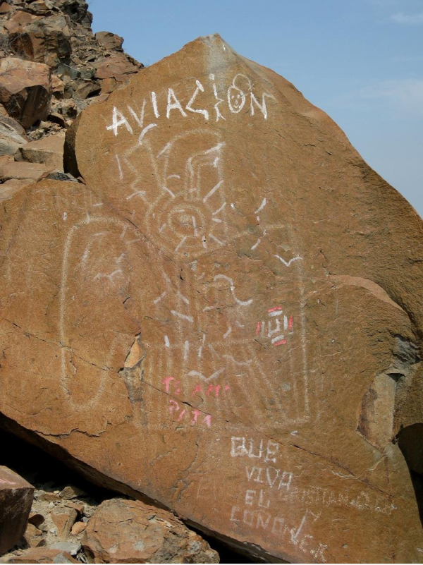 |
Figure 1. The severely vandalised petroglyph
panel at Saltur, Lambayeque, northern Peru.
Photograph © by Maarten van Hoek.
|
Visiting a rock art site can be completely harmless,
but too often unwanted situations occur, like those cyclists who camped next to
petroglyph boulders at Quebrada de los Boliches in the north of Peru. Those individuals definitely
were not aware of the negative effect of fire and smoke on rock art panels and
rock art sites. Another most unwanted effect of rock art sites becoming known
to the public is that visitors (and rock art researchers?) are ‘enhancing’ petroglyphs by scratching or by adding paint, chalk
or some other substance onto the design to make them ‘better visible’. See for
instance photos by archaeologist Paúl Jofrey
Álvarez Zeballos who probably chalked in several petroglyphs at Alto de
Pitis (2009: Figs 8 and 11); a
disrespectful action for any archaeologist. Many shocking examples were also
noticed by us at Quebrada de San Juan in Virú, northern Peru, where several
petroglyphs had been ‘highlighted’ by some vandal (moreover incorrectly and
incompletely) with an unknown black substance. This happened only very
recently, probably in 2011 or 2012 (Figure 2).
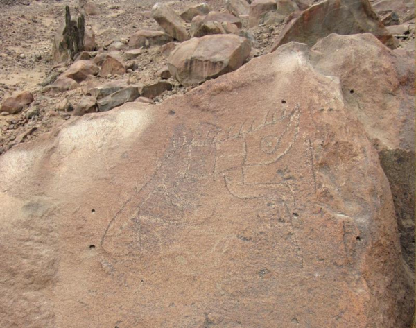 |
Figure 2. Vandalised petroglyph panel at
Quebrada de San Juan, La Libertad, northern Peru.
Photograph © by Maarten van Hoek.
|
All sorts of ‘works’ in the field often lead to
destruction of archaeological sites. Today such damage can best be seen with
the Historical Imagery in Google Earth. In this way it is possible to see the
irreversible damage at the Santa Rosa archaeological site (also known as the
Quiscay petroglyph site) in the Majes Valley of southern Peru (compare the Google Earth photos of 2004 to 2012 at
15°59'53.41"S and 72°27'48.08"W). I reported this fact in 2012 to
APAR, the official Peruvian Rock Art Association, but unfortunately they did
not publish this damage in their web site. At the
same time APAR did however publish reports about the destruction of the Geoglifo
del Ocho, a geoglyph
site further south in the Majes Valley; the damage and threat to Gayalopo,
a petroglyph site in the Department of Arequipa; and about an unwanted removal
of petroglyph stones at Ite,
Tacna.
Also quarrying is a severe threat
to rock art sites, globally. Unfortunately, quarrying stone often is a large
scale project. Mining of ‘sillar’ is
taking place inside the impressive gorge of Quebrada de Culebrillas near Arequipa,
southern Peru, where fortunately, the immediate threat has ended as the
quarrying very near this exceptional rock art site (Figure 3), seems to have
been stopped probably because of the laudable efforts of Augusto
Cardona Rosas who tried to end this quarrying in 2006.
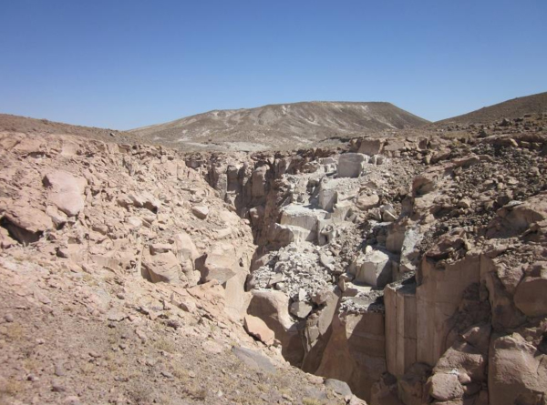 |
Figure 3. Quarrying site just west of the
Quebrada de Culebrillas site, Arequipa, southern Peru.
Photograph © by Maarten van Hoek.
|
Two other rock art sites under
threat are the neighbouring Mollebaya Chico and Uchumayo, both very near a
quarrying site. Moreover, in the very near future Mollebaya Chico (and
Culebrillas as well) will be even better accessible because of the newly
constructed highway from Arequipa to La Joya (the first part - Arequipa to
Mollebaya - was finished in 2012). I fear that tourist agencies in Arequipa
city will include both Culebrillas and Mollebaya Chico as tourist attractions
(as a kind of ‘nearby Toro Muerto’), which will possibly add to the risk of the
site being vandalised. In October 2012 an article in La
República - Región Sur - already narrated the destruction of rock art at Mollebaya Chico. Although the crack
in the boulder that shows in the photograph published in La República most likely is natural (when I inspected this boulder
I noticed that the colour of the patina inside the fracture is similar to the
undamaged surface), there did indeed occur several instances of destruction at
Mollebaya Chico. Nevertheless, I strongly advocate the termination of all quarrying activities in the
Mollebaya Chico zone, because it seems that small scale quarrying also reached
the petroglyph field.
Notably, one boulder at Mollebaya
Chico (Figure 4) proved to have been completely transformed into a few blocks
of ‘sillar’; the shaped white stones
with which many buildings in Arequipa City - La Ciudad Blanca - and others in the area have been constructed.
This small scale quarrying definitely happened after 2011, and in 2012 I could
not tell anymore whether this destroyed boulder originally was one of the many
petroglyph boulders that I surveyed at this site in 2011. A nearby boulder
(Figure 5) has been severely damaged; possibly in an idiotic attempt to steal
petroglyphs.
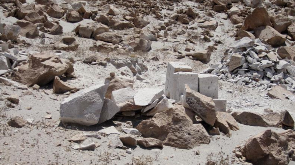 |
Figure 4. Destroyed (petroglyph?) boulder at Mollebaya Chico,
Arequipa, southern Peru.
Photograph © by Maarten van Hoek; 2012.
|
|
Figure 5. Damaged petroglyph boulder at Mollebaya Chico, Arequipa, southern Peru.
Photograph © by Maarten van Hoek; 2012.
|
In other cases (severe) damage is
caused by the use of heavy machinery. This is quite evident at the petroglyph
boulder field at Huaca Blanca in the north of Peru where several large boulders
have been disturbed, overturned and damaged by heavy machinery. Some boulders
may even have been destroyed/removed by the construction of the new road through the
village. Not far from Huaca Blanca is the exceptional petroglyph site of
Desaguadero (Van Hoek 2012: 255-258). Sadly, in January 2014 Mr. Francisco Diaz Núñez, a dedicated rock art
investigator from Pátapo in Lambayeque, emailed me several photographs
showing the destruction of at least one of the petroglyph boulders (DES-002;
possibly another petroglyph boulder - DES-003, discovered by me in 2009 - has
also been removed) and the whole site it was located in. It was a shock to see
how heavy machinery disgracefully and disrespectfully bulldozed the entire
site. The only ‘fortunate’ thing is that, thanks to Francisco Diaz Núñez and
Ignacio Alva Meneses, videos, photographs and a drawing
(Van Hoek 2012: 258) of petroglyph boulder DES-002 have been made before the unexpected
and unwanted destruction. The issue of using heavy machinery at
archaeological sites brings me to discuss the Motocachy Pampa Disaster.
The
Motocachy Pampa Archaeological Site
Before I start my discussion about
the Motocachy Pampa Disaster, I would like to emphasise again that every instance of vandalism/destruction
of rock art is a disaster. It is only a matter of scale. However, my wife and I
were shocked to see the scale on which much of the Motocachy Pampa area, a
large area with several archaeological sites, had been destroyed, although a casual
visitor to the area would hardly have noticed the destruction today. Also for
that reason it is a disaster; the destruction is going on progressively and
unnoticed. Almost unnoticed; hence
this report.
Motocachy Pampa is an extensive and
important petroglyph/archaeological site on the north bank of the Nepeña Valley
of northern Peru (detail-maps available
from the author). In 2009 the site was kindly brought to my attention by Prof. Donald
Proulx of the Department of Anthropology, University of Massachusetts, U.S.A.,
who - last century - recorded more than 250 archaeological sites in Nepeña
(Proulx 1973), among which were a large number of petroglyphs on Motocachy
Pampa. After consulting Dr. Proulx, I labelled the two petroglyph sites that he
and his team discovered Motocachy Pampa 1 (MP1; originally labelled by Proulx as PV31-155, with 17 petroglyph boulders
reported by him at that time) and Motocachy
Pampa 2 (MP2; originally labelled as PV31-222, with three petroglyph
boulders reported by him at that time).
Moreover, in 2009 Dr. Proulx
informed me that, a few years after his discoveries, another site with
petroglyphs had been reported at Motocachy Pampa by his graduate student,
Richard Daggett and his wife Cheryl (Daggett 1984). In fact it proved to be two
different sites that were recorded for the first time by Richard and Cheryl Daggett on July 2, 1981. These sites were
consequently labelled by me as Motocachy
Pampa 3 (MP3; originally labelled by Daggett as PV31-360
and PV31-361, with six
petroglyph boulders recorded by them) and as Motocachy Pampa 6 (MP6; originally labelled as PV31-362, with three petroglyph boulders recorded by them).
During our visits to
Motocachy Pampa in 2012 my wife and I were able to record 93 petroglyph
boulders at Motocachy Pampa 1 (MP1; not counting six other boulders recorded by Dr. Proulx that were untraceable during
our surveys); 13 boulders at Site 2 (MP2; not counting one extra boulder
recorded by Dr. Proulx that was untraceable during our surveys); 18 boulders at
Site 3 (MP3; including the two boulders recorded by Cheryl and Richard
Daggett); one petroglyph panel at Site 4 (MP4; discovered by us in 2012); three
boulders at Site 5 (MP5; also discovered by us in 2012) and five boulders at
Site 7 (MP7; also discovered by us in 2012; a site where Richard and Cheryl
Daggett recorded three extra petroglyph boulders). We were unable to locate
Site 6 (MP6; where Richard and Cheryl Daggett recorded three boulders in a now
heavily disturbed area). Altogether my wife and I recorded 134 petroglyph
boulders at Motocachy Pampa, not counting 13 boulders previously recorded by
Proulx or by
the Daggetts. Fortunately those rock art researchers
made photographs of the petroglyph boulders and - much later - they were so
kind to share those valuable pictures with me.
The
Motocachy Pampa Disaster
Importantly, when Dr. Proulx recorded
the Motocachy Pampa rock art sites between 1967 and 1979, those sites showed no
evidence of having been disturbed, vandalized and no boulders proved to have
been moved (Proulx 2012: pers. comm.). Alas, how different was the situation in
2012 (and even worse in 2013 according to Google Earth). Large areas of the
extensive Pampa had been cultivated (in itself a mutilation) and, probably in
order to facilitate the cultivation, heavy machinery moved obstacles - mainly
boulders - from the flat sands, especially in the contact zones where the Pampa
meets the hill slopes (the Pampa itself was and still is almost void of
boulders or stones). Also several modern dirt-tracks now crisscross the Pampa,
making almost every archaeological zone easily accessible.
Thousands of deeply patinated
boulders cover many of the hill slopes that border the flat Pampa, but as a
consequence are also found at the very foot of the slopes and on a small strip
of the plain adjacent to the hill slope. It is in that contact zone that Dr.
Proulx noticed the first petroglyph boulders and especially and unfortunately
in that small strip the major concentrations of petroglyph boulders occur. This
vulnerable border zone now has been bulldozed in order to remove the boulders
from the flat soils in order to allow agriculture. These boulders were often ‘rücksichtslos’ (mercilessly) deposited
on top of or among the other boulders, only a little higher up the contact zone
between plain and hill. At several places this disturbance is very extensive.
In one case a bulldozer was driven to the very
top of one of the hills, severely disturbing the affected area (and possibly
disturbing and damaging several petroglyph boulders). At other places the
negative impact has faded because time has obscured the ‘wounds’ (for instance
by drifting sand). Yet, many petroglyph boulders still show severe scarring by
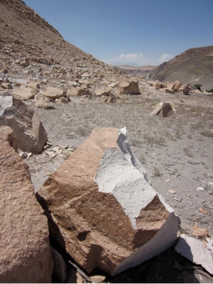
the action of the heavy machinery (Figure 6). Moreover, in many cases one
cannot be sure about the original position of the boulders anymore and thus
further important archaeological information is lost forever.
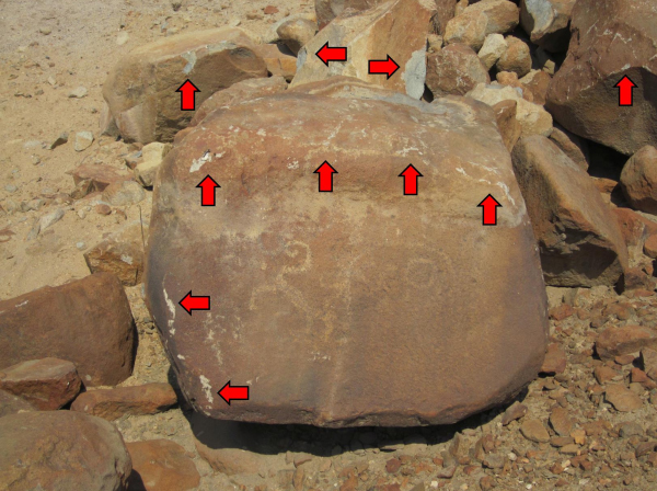 |
Figure 6. Damaged (petroglyph) boulders at Motocachy Pampa, Ancash, northern Peru.
Photograph © by Maarten van Hoek.
|
In order to allow water to reach
the cultivated areas, trenches (often very deep) now cut through Motocachy
Pampa. Because the higher part is at the east,
those trenches run from SE (where the river Nepeña flows - the only source of
water) and east to the west (making use of the natural slope of the Pampa). A
major deep trench has been dug directly east of the hill slope where the
Daggetts recorded three petroglyph rocks in 1981. My wife and I searched that
zone but the debris from the trench was piled up too high along the hill slope
and we could not relocate any of the petroglyph stones.
Added to this damage is an act of
perplexing vandalism at one of the Motocachy Pampa sites. Not in the contact
zone itself, but located a little higher up the hill slope and ‘out of reach’
of heavy machinery (but not out of reach of vandals) is an outstanding
petroglyph boulder. It certainly was undamaged when Dr. Proulx photographed
this boulder in 1971 (Figure 8). How sad it was to see that some unintelligent
vandals severely and violently damaged this boulder (Figures 7, 8, 9, 10 and
11), possibly in a brainless attempt to reduce the size and to subsequently
steal it. ‘Fortunately’, the most important part of the petroglyph panel
remains more or less ‘undamaged’, but the stone and the site were relentlessly violated nevertheless. I consider
this act of disrespectful vandalism, and all others mentioned in this paper, to
be serious desecrations of a sacred sites once revered by the ancient Andeans.
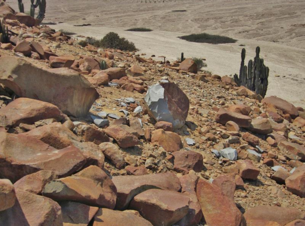 |
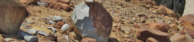
Figure 7. Damaged petroglyph boulder at Motocachy Pampa, Ancash, northern Peru.
Notice that the many fragments from this
boulder are lying scattered around across a wide area.
Photograph © by Maarten van Hoek.
|
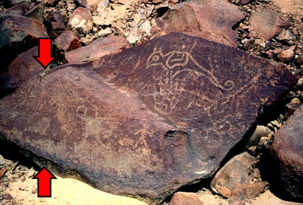 |
Figure 8. The same petroglyph boulder at Motocachy Pampa, Ancash, northern Peru.
The red arrows indicate the left part that
recently has been destroyed (compare with Figure 9).
Photograph © by Donald A. Proulx; 1971.
|
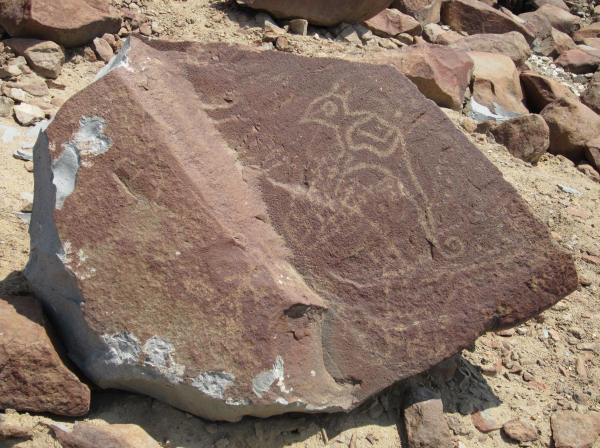 |
Figure 9. The same petroglyph boulder at Motocachy Pampa, Ancash, northern Peru.
Photograph © by Maarten van Hoek; 2012.
|
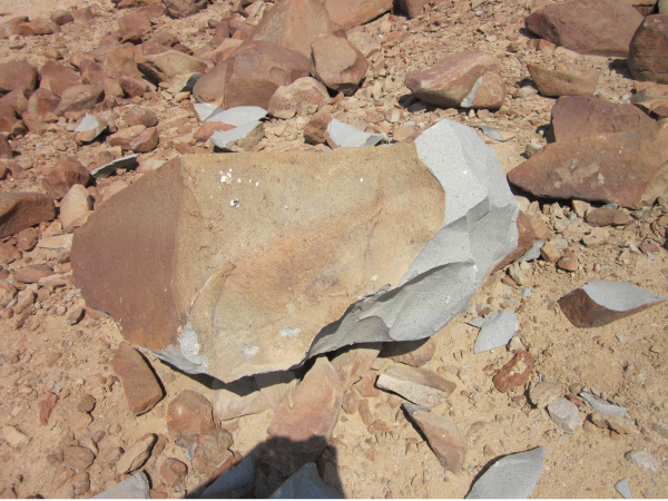 |
Figure 10. The top of the same petroglyph
boulder at Motocachy Pampa, Ancash, northern Peru.
Photograph © by Maarten van Hoek.
|
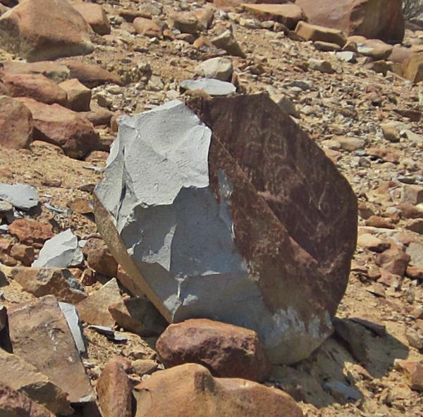 |
Figure 11. The left side of the same
petroglyph boulder at Motocachy Pampa, Ancash,
northern Peru.
Photograph © by Maarten van Hoek.
|
The Motocachy Pampa Disaster
Continues
There is another negative
consequence of the use of heavy machinery at Motocachy Pampa that,
unfortunately, I cannot prove. However, because Donald Proulx and Richard and
Cheryl Daggett wisely took photographs of the petroglyphs that they discovered
and, many years later, kindly made those photographs available to me, I can now
suggest (prove?) that at Motocachy Pampa petroglyph stones have been stolen as
well. I also fear that this was easy to do because heavy machinery can not only
dislocate and move boulders, but also transport them to unknown destinations
without any effort. However, I hope that - someday - the ‘stolen’ boulders will
be re-discovered unscathed (hopefully they have only been moved and/or buried
at the site).
The first case concerns a boulder
(marked ‘A’ in Figure 12) that is located almost adjacent another boulder
(marked ‘B’ in Figure 12) in a photograph made by Donald Proulx in 1971. We
were able to locate and photograph boulder ‘B’, but unfortunately, many
searches by my wife and me of the zone failed in finding boulder ‘A’, which, I
fear, has been stolen. The petroglyphs on boulder ‘A’ are notably very clear
(and thus interesting to looters) and it moreover concerns a rather small
boulder that is easy to remove. It might have been moved in situ and the decorated surface buried, but as this particular
area was not that severely disturbed, I seriously doubt it.
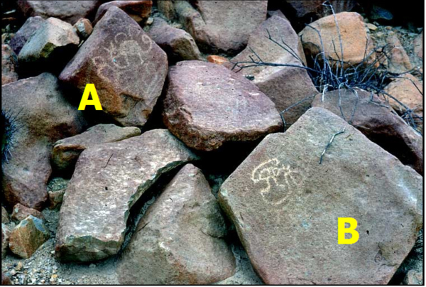 |
Figure 12. Petroglyph boulders at Motocachy Pampa, Ancash, northern Peru.
Photograph © by Donald A. Proulx; 1971.
|
In the very same zone we looked for
a most important petroglyph of an MSC-Style agnatic face (Van Hoek 2011b: Fig.
118) first reported by Dr. Proulx in 1971 (Proulx 1973: Fig. 17), but the
several extensive searches by my wife and me were not successful (in 2012 we
found another fine MSC-Style petroglyph, though). Altogether, six petroglyphs
boulders discovered by Dr. Proulx at this zone could not be relocated by us
during our 2012 surveys. It is therefore a very fortunate circumstance that Dr.
Proulx took photographs in 1971.
The second case concerns a similar
situation. In 1971 Dr. Proulx recorded another most interesting petroglyph on a
boulder (marked ‘C’ in Figure 13) at another zone at Motocachy Pampa. Again it
was located very close to another (‘less’ interesting looking) petroglyph
boulder (marked ‘D’ in Figure 13) that was relocated by us in 2012, almost
certainly still ‘in situ’. But there
was no trace of boulder ‘C’ anymore. It is almost impossible to miss a
petroglyph boulder like boulder ‘C’ when especially searching for it. I
therefore fear that this boulder too has been stolen especially because of its
clear and most interesting design (which is unique in Andean rock art, as far
as I could check). Unfortunately, this rock was also very easily accessible
from a nearby road.
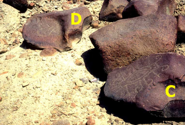 |
Figure 13. Petroglyph boulders at Motocachy Pampa, Ancash, northern Peru.
Photograph © by Donald A. Proulx; 1971.
|
The third case concerns the recording
of three petroglyph boulders discovered and photographed by Cheryl and Richard
Daggett in 1981 ‘at the top of the ridge’
of one of the Motocachy Pampa sites (Daggett 2012: pers. comm.). My wife Elles
and I searched that very area in 2012 and discovered five petroglyph boulders
more or less near the same spot, but not the three stones found by the Daggetts
in 1981. We may have missed those three boulders, but equally they may have
been disturbed, moved or stolen as we noticed a track made by heavy machinery
running up the rather steep hill at this zone (and what reason would there have
been to go uphill with heavy machinery?). Fortunately, Cheryl and Richard
Daggett made photographs of the stones (one example is shown in Figure 14),
which brings me to final next point in which the context is decisive.
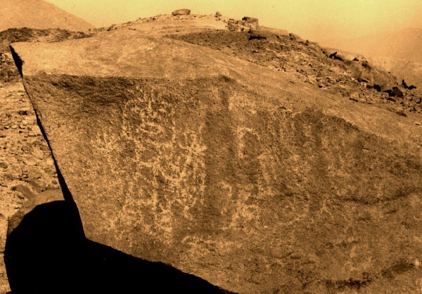 |
Figure 14. Petroglyph boulder at Motocachy Pampa, Ancash, northern Peru.
Photograph © by Richard Daggett; 1981
(digitally enhanced by the author). |
The Importance of Photography
I have
always advocated a positive attitude towards the protection of rock art in my
publications about Andean rock art. During and after my surveys I have always
shown respect for the sites that the ancient Andeans considered being sacred.
One aspect of my code of ethics is: always keep a respectful distance towards rock art. However, a respectful distance does not involve an
absolute concept; it is a relative concept. This brings me to discuss the
famous Mona Lisa painting by Leonardo da Vinci. It is quite understandable that
visitors to the Louvre in Paris are forced to observe the painting at a respectful
distance as today it is displayed behind
bullet-proof glass in a purpose-built enclosure. On the other hand, if some lunatic were to damage the painting, the
restorer would be forced to touch the painting, but even then there is the
question of a respectful distance.
The restorer knows what she or he is respectfully doing and everybody will
accept this respectful distance of
zero metres. Therefore, it is a combined set of factors that determines the respectful distance with which also a
rock art panel may be approached. First and foremost the mentality of the observer (researcher/photographer) determines the
distance that is allowed and secondly the know-how of the researcher is crucial.
Thus,
when Robert
Bednarik, a renowned rock art researcher, investigates a rock art panel at
Checta, central Peru, from a very close distance, he still shows a respectful distance because he knows
what he is doing. Bednarik even touches rock art panels. For instance, during
his visit to La
Galgada in northern Peru in 2012, he touches with his hand a petroglyph
stone, while Echevarría López (Arqueólogo,
Unversidad Nacional Mayor de San Marcos and Presidente, Asociación Peruana de Arte Rupestre - APAR), who invited him to Peru, is watching from
very close. However, the IFRAO code of ethics (and APAR’s) demands people not to touch rock art. Yet, Bednarik
will rightfully not be criticised for this; not by me and obviously not by
Echevarría López.
However, my investigations in Peru
have been seriously criticised. In two emails Echevarría López ‘demanded’ that I should stop my researches in
Peru immediately. He wrote to me (2011: pers. com.): Ud. está actuando como un
"old cowboy" en el Perú Pare, desista, deténgase, renuncie, en intervenir, explorar o survey los sitios arqueológicos con
quilcas o arte rupestre del Perú. He moreover accused me of damaging practices: Sus acciones y su ejemplo le
causan un daño irreversible a los sitios arqueológicos peruanos although he did not
offer any factual evidence of physical ‘damage’ caused by me. The fact that I
informed him that I only survey a rock art site by taking photographs was - in
his opinion - no excuse. Although I
have been surveying and photographing rock art in the field for more than 35
years now (in various areas of the world), I acknowledge that I have not the
same degree of know-how as Bednarik. But I definitely have the same degree of
respect for (Andean) rock art and for that reason I do not touch rock art
panels disrespectfully. I only make photographs.
The Motocachy Pampa Disaster and
all other instances of ongoing rock art destruction (not only in Peru, but the
world over) prove how enormously valuable (photo)graphic records are. For
instance, without the photographs made by Donald Proulx and Cheryl and Richard
Daggett it would never have been possible to present a more detailed impression
of the petroglyph art at Motocachy Pampa. And with my own photographic records
it can be ‘reconstructed’ how the petroglyphs at Quebrada de San Juan (and at
many other sites) looked like before being damaged.
Ignorance and escalating vandalism
by locals and tourists and increasing destruction caused by agricultural and
infrastructural ‘progress’ combined with the unstoppable natural destructive
forces, like weathering and erosion, will be responsible for the loss of many
rock art panels and rock art sites, in Peru and elsewhere. These negative
developments make it even more beneficial and (highly) compulsory that
photographic records are made and made available.
In this respect it does not matter
at all who made the photographic record, as long as the recording is done
carefully and respectfully. Every record or photograph of a rock art panel or
rock art site should be welcomed as a most valuable contribution to the rock
art conservation of a country. For me, it is therefore completely
incomprehensible that I was demanded to stop my (photographic) surveys in Peru.
Instead, every official organisation advocating rock art protection should be
most interested to know about, learn and benefit from such photographic
records.
In conclusion, there are two ways
to protect rock art for the future. First, in theory every rock art site should
be permanently supervised and guarded by vigilant officials. As it is
impossible to realise this for all sites in the Andes, the second - more
realistic - method is to meticulously record all rock art panels at every site
through photography and other means. Then it should not matter whether the
recording is carried out by non-academics or by professional archaeologists as
long as it is done respectfully and carefully. I hope my plea will receive a
positive response.
Acknowledgements
This paper could never
have been written without the invaluable assistance of Prof. Donald Proulx of the
Department of Anthropology of the University of Massachusetts, Amherst. He has been so kind as to supply me with
several photos/drawings of Nepeña rock art and much additional information. As
ever he sympathetically permitted me to use several of his photographs in this
article. I also appreciate very much that Donald Proulx has been so kind to
read and comment on this paper and to improve the English where necessary. But
of course the whole content is my responsibility only. I am as well indebted to Dr. Richard E. Daggett, also of the Department
of Anthropology of the University of Massachusetts, Amherst,
to supply me with photographs and information about the sites that he and his
wife Cheryl discovered at Motocachy. Richard Daggett also kindly allowed me to
use his photographs, one of which has been included in this paper. I also thank Mr. Francisco Diaz Núñez for informing me about the destruction of a rock art site
in Lambayeque. Last but not least I thank my wife Elles for her valuable
assistance during our 2012-Motocachy surveys.

—¿Preguntas,
comentarios? escriba a: rupestreweb@yahoogroups.com—
Cómo citar este artículo:
van Hoek, Maarten.The
Motocachy Pampa Disaster:
A Tale of
Neglect of Rock Art. En Rupestreweb, http://www.rupestreweb.info/motocachy.html
2014
REFERENCES
(Underlined references
in blue - also in the text above - are hyperlinks as accessible in 2014)
Álvarez Zeballos, P. J. 2009. Petroglifos de Cantas, Pitis,
La Mezana y La Laja; Valle de Majes. In: Arqueología de Perú.
CIHDE. 2012. Petroglifos
de Ofragía. Herencia Cultural del Valle de Codpa, Chile. Centro de
Investigaciones del Hombre en el Desierto; Ilustre Municipalidad de Camarones. Arica, Chile.
Daggett,
R. E. 1984. The Early
Horizon Occupation of the Nepeña Valley, North Central Coast of Peru.Ph.D. dissertation, Department of Anthropology, University of Massachusetts,
Amherst.
Nieves, A. C. 2007. Between
the river and the pampa: a contextual approach to the rock art of the Nasca
Valley (Grande River system), Department of Ica, Peru. Ph.D. Dissertation,
Department of Art, The University of Texas at Austin, U.S.A.
Proulx,
D. A. 1973. Archaeological Investigations in the
Nepeña Valley, Peru. Anthropology Research Reports - Research Report 13. University
of Massachusetts, Amherst, USA.
Tung, T.
A. 2007. The village of Beringa at the periphery of the Wari Empire: a site
overview and new radiocarbon dates. Andean
Past (PDF). Vol. 8; pp 253 - 286.
Van Hoek,
M. 2005. Los Petroglifos de Muralla y Pakra, Valle de Pisco, Perú. Boletín de SIARB (PDF), Vol. 19; pp 28 - 37. La
Paz, Bolivia.
Van Hoek, M. 2011a. Cerro Pano: A violated and endangered rock art site in Southern Perú. In Rupestreweb.
Van
Hoek, M. 2011b. The
Chavín Controversy - Rock Art from the Andean Formative Period. Oisterwijk,
The Netherlands. Privately Published using the BLURB Creative
Publishing Service.
|