Andean petroglyphs and Yanantin. The case of El Olivar, Ancash, Peru

Maarten van Hoek. rockart@home.nl


Introduction

El Olivar is a small petroglyph site in the valley of the Río Sechín, 317 km NNW of the Plaza Mayor in Lima, the capital of Peru. Although far apart, the petroglyph site and the Plaza have one thing in common. Notably, the colour scheme of the attractive flower beds on the Plaza Mayor seems to be an echo from the past, as both the petroglyph site and the Plaza Mayor flower beds show the contrasting colours of red and white (Figure 1). This resemblance is most likely to be fortuitous, as the red and white flowers more likely are intended to reflect the colours of the flag of Peru.

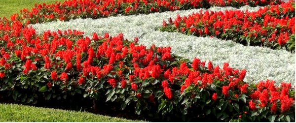
Figure 1. Contrasting flower beds of the Plaza Mayor in Lima, the capital of Peru.
Photograph © by Maarten van Hoek.

Interestingly however, much of the petroglyph art in this part of the Andes features (rather: featured) the same contrasting colours, surprisingly at micro level and at macro level. Importantly, in the natural landscape the contrasting colours hardly ever are pure white and true red. Nevertheless, for matters of convenience I will still use the terms ‘red’ and ‘white’ throughout the text, but it will become clear that mainly the contrast between darker colours (for instance black, red, purple, brown) and brighter colours (white, yellow, grey) is decisive.

The only goal of this paper is to offer an impression of the rock art at Olivar and to communicate a hypothesis about a specific relationship between petroglyph production and ancient Andean worldview. It is not at all my intention to offer any kind of scientific inventory of the rock art site of El Olivar. I also do not want to pretend that I can offer a complete scientific archaeological record for the area. I leave that to the academic, professional archaeologists.

In this paper the individual petroglyph panels at El Olivar will only be described; no photos will be shown. However, in a video, especially made to accompany this paper, all panels that I surveyed have been included, as well as several maps and shots of the environment. The video has Spanish texts and is called Los Petroglifos de El Olivar - Río Sechín - Perú (all hyperlinks in this paper were functioning at the time of submission - March 2015).


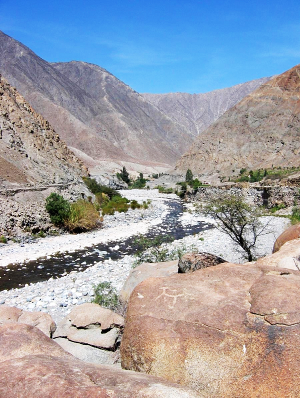
The Archaeological Context

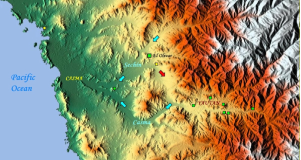
The valleys of the Río Sechín and adjacent Río Casma (Figure 2) are famous for especially its Formative Period archaeological monuments. About 20 km SE of El Olivar is the complex of Formative Period monuments of - among many others - Cerro Sechín, Sechín Bajo and Sechín Alto and several other ancient structures, many of which are lavishly decorated. The zone near El Olivar (Figure 3) is less well documented but features as well many prehistoric ruins that to my knowledge have not yet been excavated. About 1.5 km to the north of the petroglyph site and located on the floodplain of the Río Sechín (10 in Figure 4) and on the edge of the hamlet of Olivar Bajo (at 340 m O.D.) are the remains of Huaca de El Olivar (6 in Figure 4), while 760 m to the SE is a possible Tambo (resting place) (11 in Figure 4). Opposite the Huaca de El Olivar the SE facing hill slopes of the Sechín Valley are littered with prehistoric structures and terraces (7 in Figure 4), indicating the significance of this particular zone in prehistoric times. Another important archaeological feature confirms the key position of this area. This feature will be discussed further below.

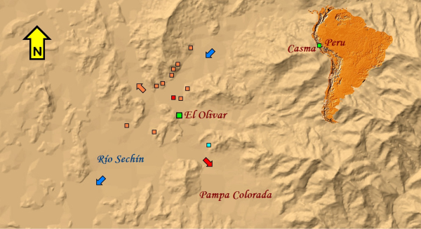
Figure 2. Map showing the location of the El Olivar petroglyph site in the Sechín Valley, Ancash, Peru.
Green squares: rock art sites; yellow squares: geoglyph sites. Map © by Maarten van Hoek, based on
Google Earth Relief Maps
.
Figure 3. Map showing the location of the El Olivar petroglyph site in the Sechín Valley, Ancash, Peru.
Map © by Maarten van Hoek, based on Carta educativa de las Direcciones Regionales de
Educación y Unidades de Gestión Educativa Local. (Ugel_Casma.PDF)
.

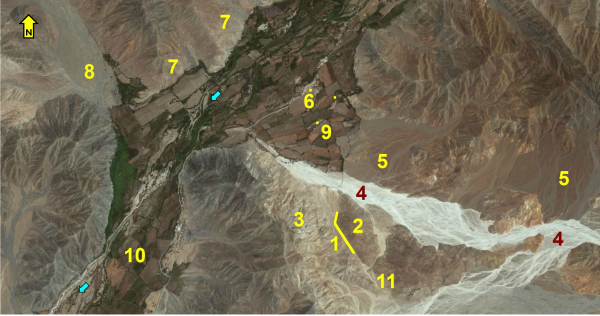
Figure 4. Detail map showing the location of the El Olivar petroglyph site (1) in the Sechín Valley, Ancash, Peru. Further explanation in the text. Map © by Maarten van Hoek, based on Google Earth.

A short distance to the ESE and SSE of the Huaca de El Olivar I passed two small mounds (9 in Figure 4) suggested by Dr. Robert Benfer (2011) to (possibly) represent birds, while both their orientations (Azimuth 64?) are claimed by him to point to the June solstice sunrise (however, to me the choice of only the ‘head’ of the sinuous mound is completely arbitrarily; why not considering the Azimuths of the ‘neck’ or the ‘body’ of the ‘bird’?). However, those features are located in the Sechín Valley, not in the Casma Valley as Benfer claims.

In my opinion the claims by Benfer need to be scientifically checked in the field, especially as the lines of visibility of 64? seem to be blocked by a mountain ridge of respectively 495 and 527 m in altitude (located respectively 695 and 1269 m to the NE of the sinuous and linear mound). It also should be checked whether those mounds are naturally and/or artificially shaped. Moreover, it is fairly easy to recognise animal shapes in the many - probably naturally shaped - mounds in such Andean river valleys (for instance at 9° 26' 13.53" S. and 78° 13' 40.43" W. a ‘fish’ shaped mound may be recognised). Robert Benfer (2011) also claims that ‘a large bird geoglyph is also known from the valley’ referring to Pozorski et al. (1991) who indeed reported a bird geoglyph, but not in the Sechín Valley, but at Huaynuná on the coast, about 18 km north of Casma and 28 km WNW of El Olivar (indicated with a yellow square in Figure 2).

The deserts between the Andes and the Pacific Ocean are rich in petroglyph sites, but the petroglyph site of El Olivar is the third rock art site so far recorded in the Sechín Valley. The earliest record of rock art in the Sechín Valley probably concerns the isolated petroglyph boulder at Cerro Sechín (possibly first reported by Julio C. Tello in 1937), located very near the confluence of the Sechín and Casma rivers (indicated with a green square in Figure 2). Later, a second petroglyph site was reported near the town of Cunca, about 21 km upstream from Cerro Sechín. Later still, the petroglyph site of El Olivar appeared on the internet.

Other (and more extensive) petroglyph sites are found in the Casma Valley around Yautan (Suárez Ubillúz 2006), roughly 25 km SE of El Olivar (indicated with a cluster of green squares in Figure 2), and in the Nepeña Valley around the town of Moro (Proulx 1973; Van Hoek 2014a), roughly 29 km north of El Olivar.

The Petroglyph Site of El Olivar

El Olivar is a small petroglyph site near the valley of the Río Sechín (Departamento de Ancash / Provincia de Casma / Distrito de Buena Vista Alta), located roughly 25 km inland and about 2 km SE of the river Sechín (Figures 2, 3 and 4; see video). 
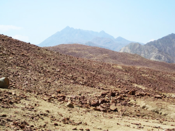
The site is located in a typical Andean desert landscape. There is a very sharp contrast between the lush, fertile river valley and the barren desert that immediately borders the valley. From (near) the site spectacular vistas of the surrounding mountains can be seen, especially to the east (Figure 5; see video). There is no vegetation at the site of El Olivar. Only in the dry river bed of the Quebrada Tucushuanca (to the north of the site), isolated low trees, some scrubs and scrubby vegetation occasionally occur. Because of the rare torrential downpours (possibly caused by El Niño’s) this vegetation only survives at the borders and somewhat higher places. Also, at several places deep gullies have been carved out by such downpours south of El Olivar (Figure 6; see video).

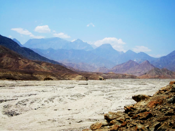
Figure 5. Looking east across the dry river bed of Quebrada Tucushuanca (4 in Figure 4)
 A possibly prehistoric crossing place seems to be indicated with a line of boulders.
Photograph © by Maarten van Hoek, 2015.

The petroglyph boulders that make up the site (green square in Figures 2 and 3; yellow line and 1 in Figure 4) are more or less linearly arranged over a length of 580 m, while the width of the site is no more than 30 m. This linear arrangement of petroglyph boulders rises from 350 m O.D. at its north end to 390 m O.D. further SE.

The petroglyph site of El Olivar is largely unknown. It is not listed in the Inventario Nacional compiled by Rainer Hostnig (2003), and - as far as I know - also not listed by the Instituto Nacional de Cultura de Perú (situation 2011). The site came under my attention via the internet where a blog by Augusto Llosa Giraldo (2011) presented El Olivar as a threatened site. Llosa Giraldo wrote:

El Olivar es un sector del distrito de Buenavista Alta, que dista unos 5 kilometros en la carretera que va hacia Quillo, en donde se encuentran un sin numero de dibujos trabajados  sobre piedras por  hombres que poblaron este lugar. Y sin  lugar a duda se puede observar que su antiguedad es mayor que otros vestigios arqueògicos de la provincia. Esta zona arqueòlogica esta abandonada y al parecer no està inventariada por el Instituto Nacional de Cultura - I.N.C. y como tal no tiene protecciòn oficial. Esperamos que las nuevas autoridades pongan en valor este zona que guarda una rico historial de nuestro pasado. (Llosa Giraldo 2011).

Together with this short text, 15 good quality photographs (with captions) of the environment and of some petroglyph boulders appear in the blog. Although the text did not mention the number of petroglyphs or petroglyph boulders, the photos revealed that at least four petroglyph boulders had been recorded by Llosa Giraldo in 2011. Our surveys in 2012 yielded no less than 15 boulders with one or more images (three previously reported by Llosa Giraldo in 2011). Probably all boulders are of andesite; a hard type of igneous stone that over time develops an attractive red patina, although all shades of red, black, brown and yellow occur at El Olivar, like at many other places in the Andes. All 15 petroglyph boulders are found at the very foot of a low hill that rises to the east of the linear arrangement. This hill, the westernmost extension of Cerro Colorado (2 in Figures 4 and 6), is littered with small and medium sized red boulders and a few larger ones (Figure 9). At some places those smaller boulders seem to have been moved to form geoglyphs (the area above ‘2’ in Figure 6; see video).
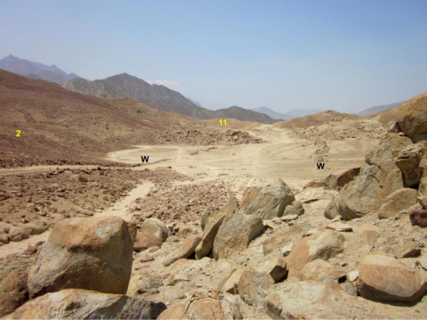
Figure 6. Looking SE across the southern end of the pass towards the (invisible)
Pampa Colorada. W: Walls of the Cupisnique Road; 2: the SE end of Cerro Colorado
(above the ‘2’ are possibly some geoglyphs (see video); 11: the location of the possible Tambo
(invisible) and other features. Photograph © by Maarten van Hoek, 2015.


The Petroglyph Boulders
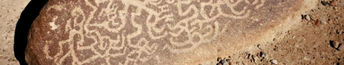
There are at least 15 petroglyph boulders (rocas) that I have labelled OVR-001 to OVR-015. A 16th boulder (OVR-016), reported by Llosa Giraldo (2011), was not noticed by us. Those 16 boulders will be briefly described roughly from north to south. When having more than one decorated panel, capital letters have been added (for instance OVR-002A etc). All petroglyphs have been manufactured by superficially pecking away the thin layer of patinated stone. Most images appear deeply patinated and many could only be distinguished with difficulty. Therefore there may be more petroglyphs or decorated panels/boulders that may show up in different or better lighting conditions. Measurements have not been taken during our photographic survey. Also the bearings of the decorated surfaces have not been registered, especially as many boulders may have been disturbed, because this sacred site has been violated by a modern dirt track, while its north end has been transformed into a modern cemetery, emphasising (but probably also disturbing) the sacred nature of the spot.

In this paper no illustrations/photos of the petroglyph panels are given. Instead, I have made a YouTube video in which all 15 petroglyph boulders that were recorded at this occasion are shown (photos of Boulder OVR-16 can be seen in the blog by Llosa Giraldo). Please keep in mind that many petroglyphs at El Olivar are extremely faint and only show up very faintly in the video. For that reason all photos have been digitally enhanced by me. Only a selection of photographs and video-fragments of the rock art panels has been included. The text in the photos is in Spanish but will be easily understood when reading this paper.

Boulder OVR-001
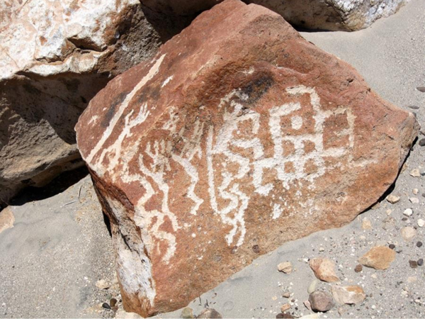
A medium sized boulder with a flat upper surface bearing a rather clear pattern of lines. One of the lines seems to form a stepped design, while others may represent the heads of biomorphs (snakes perhaps). The patination of the petroglyphs is rather bright.

Boulder OVR-002
A rather large boulder has three panels. Panel A is a vertical panel featuring a large complex pattern (a head perhaps?) of the MSC-Style (the explanation of this acronym is given below). Attached to this pattern are a possible biomorphic figure and a somewhat brighter but simple pattern of lines. Panel B is also (near) vertical. It features two large and almost horizontally arranged and frontally depicted anthropomorphic figures, both manufactured in outline. The upper figure is incomplete (weathered off or unfinished). It shows part of the upper body, short arms and an oval head featuring ears, eyes, two dots for a nose and a simple line for the mouth. It also seems to bear a ‘strange’ headgear (?). Its right hand touches the other (complete) anthropomorphic figure. It has also an oval head with similar facial features, but this time the ears seem to have earrings. Instead of a headgear, five lines radiate from the upper part of the head, possibly representing hair, a headgear or even power lines. Its right hand and foot appear on Panel C that features an imperfect oval ring (the start of a third head?).

This boulder may well have been disturbed or turned over, as anthropomorphic figures in a recumbent position are an anomaly in Andean rock art. A fine example of a recumbent anthropomorphic petroglyph occurs at La Laguna, Ascope, La Libertad, 215 km NW of El Olivar (Castillo Benites 2006: Fig. 30; incorrectly illustrating the anthropomorph in an upright position, however).

Boulder OVR-003
This again is a rather large boulder with at least four decorated panels. Panel A steeply slopes to one side and features a very much weathered pattern of lines that may well represent a kind of biomorph since three foot-like or hand-like petroglyphs are part of the design. This design is very deeply patinated and very hard to see. Panel B is the steeply sloping surface to the left of Panel A with some very faint and deeply patinated designs that are extremely hard to decipher. Panel C is to the right of Panel A. This very small, triangular panel features a set of concentric curved lines. Panel D is a large, vertical panel that features two sets of patterns made by straight lines (some of which may be natural). One set possibly depicts a small biomorphic figure (a llama?).

Boulder OVR-004
This large boulder has four decorated panels. Panel A is almost vertical. Its rough surface shows at least four petroglyphs (and possibly there are more) that are rather deeply patinated. One of the petroglyphs may portray a laterally depicted MSC-Style head (Cabeza Cupisnique?). Panel B features a number of almost invisible lines of which the pattern is indecipherable. Panel C is also almost vertical and shows a pattern of deeply patinated lines that might form a bird image and at least on S-shaped spiral. To the right is a pattern of lines that continues onto Panel D ending in a circular head with simple dots for eyes and a straight line depicting the mouth. The top of the head shows a triangular indentation thus forming two triangular (feline?) ‘ears’. Near the head are some markings (one spiral-like), while further to the right are two deep (natural or anthropic?) holes (shaped like cupules) that are enclosed/surrounded by a complex but very faint design of lines that may depict a biomorph; even an anthropomorph. These deeply patinated holes may have been incorporated intentionally into the design to represent the eyes of the purported biomorph/anthropomorph.

Boulder OVR-005
A medium sized boulder shows a number of rather bright petroglyphs near the upper end of an almost vertical panel. Dominating is a set of three (possibly four) concentric curved lines incorporating a small circle with central dot. Next to this set is a bright angular U-shape.

Boulder OVR-006
The upper surface of a medium sized boulder shows some very faint petroglyphs including a small circle and a large circle with central dot.

Boulder OVR-007
The vertical surface of this medium sized boulder shows some short, straight lines.

Boulder OVR-008
This large, irregular, eroded boulder has a set of two concentric ovals (an eye?) and a few indistinct lines/markings.

Boulder OVR-009
The upper surface of this small boulder seems to have an unfinished or weathered-off petroglyph. Only part of the outline of a possible head and the two ears (?) are visible at the moment.

Boulder OVR-010
The smooth upper surface of this small boulder (lying very close to the modern track through the site) features a design of lines that possibly represents a biomorph.

Boulder OVR-011

The almost vertical side of this medium sized boulder features a bright oval shape with a dot touching the lower side thus giving the impression of the MSC-Style eccentric eye. There are some more very indistinct marking on this panel as well as a (natural) hole that may have a pecked line around it. This boulder is just north of a low and short, ancient wall that traverses the modern track at a right angle.

Boulder OVR-012
Another medium sized boulder lies on the other (western) side of the modern track and just south of the low and short, ancient wall that traverses the modern track. It is the southernmost petroglyph boulder discovered at this occasion. Its upper surface has some very indistinct lines (some possibly natural) and a (natural) hole with a rather bright ring around it.

Boulder OVR-013
North of Boulder OVR-011 are three other petroglyph boulders. An angular boulder of medium size has some very faint lines (one group forming a pattern) on its steeply sloping and very smooth surface (partially covered by a large boulder).

Boulder OVR-014
This medium sized boulder has an almost invisible pattern of lines on its upper surface.

Boulder OVR-015
This medium sized boulder has an almost invisible pattern of lines on its almost vertical surface (some of the lines may have been formed by natural processes).

Boulder OVR-016
This is the only boulder reported by Llosa Giraldo (2011) that we missed during our survey and therefore it may well be located elsewhere, for instance further south of the low and short, ancient wall that traverses the modern track; possibly in or near the alleged Tambo (11 in Figure 4). According to the photos posted by Llosa Giraldo (2011) the boulder is part of a low wall forming a roughly circular structure.

The following description of Boulder OVR-016 is based on the four photographs by Llosa Giraldo (2011). The decorated, vertical panel of the boulder, which is incorporated in the low, circular construction and which is facing inwards, bears a three-convolution spiral, a large circle with central dot and short outward line, another, smaller circle with internal markings, two circles with central dots and short rays as if depicting ‘suns’, an irregular circle, a small oval and at least three indeterminate markings. The whitish-patinated petroglyphs are rather delicately executed and in my opinion they may represent a collection of images from another culture (other than Sechín or Cupisnique).

El Olivar as Part of the Cupisnique Road System

An important facet of this site, which possibly explains the linear character of this petroglyph group, has hitherto not been mentioned. All petroglyph boulders are more or less aligned along a prehistoric road of probably Cupisnique (Formative Period) origin. Although the factual association is uncertain (some petroglyphs may be older than the construction of the road), several of the (now disturbed?) petroglyph boulders may even have been incorporated into the ancient road on purpose.

The possible contemporaneity with the ancient road is demonstrated by the fact that several petroglyphs at El Olivar display the MSC-Style, an acronym (Van Hoek 2011) referring to specific images from the Andean Formative Period mainly manufactured by the coastal Manchay (Lima), Sechín (Casma) and Cupisnique cultures (Virú-Trujillo-Chiclayo). I thus categorically reject any Chavín origin for the (MSC-Style) petroglyphs at El Olivar. They more likely have been manufactured by the contemporary Sechín or Cupisnique cultures (although an earlier or - more likely - later date cannot be ruled out for a number of the images).

The prehistoric road actually consists of two parallel, low walls of boulders (Figure 6) with a width of 20 to 30 m, while two short, much narrower roads (width 3 to 4 m) connect the main road with the possibly ancient structure (the alleged Tambo; 11 in Figures 4 and 6) 760 m SE of El Olivar. The interior between the parallel walls has largely been cleared of (the larger stones). At certain spots only one wall has been constructed (this happens quite often elsewhere in this part of the Andes). Although several sections of the bordering walls may also have disappeared because the destructive forces of downpours and floods caused by El Niño’s and also because of the construction of modern tracks and other recent activities, it is possible to trace the road (also with Google Earth) to the SE for about 3.5 km where it connects with Pampa Colorada (Figure 3; see video) (because of several factors a section of about 3.3 km of this road is untraceable at the moment, but it reappears again for 4.4 km). This section of the ancient road (red arrow in Figure 3) probably was part of the ‘coastal’ route from the valley of the Río Sechín via the Pampa Colorada to the valley of the Río Casma, further south.

Interestingly though, David Johnson and Aurelio Rodriguez (2009) consider the low, linear walls that outline such ancient roads to be geoglyphs. Indeed, authentic prehistoric geoglyphs have been reported at Pampa Colorada (see video) and I noticed some possible geoglyphs on the slopes of Cerro Colorado (see Figure 6; see video). The geoglyphs at Pampa Colorado - that can, with difficulty, be recognised with Google Earth today - are located just west of Cerro Buenos Aires, about 3 km SE of the petroglyph site at El Olivar and 360 m NE of the ancient road (blue square in Figure 3). They are invisible from a nearby ancient road as they have been constructed on an almost horizontal part of an alluvial fan, not on a hill slope. Conversely, according to the description by Johnson and Rodriguez (2009) the geoglyphs described by León Ascurra (1996) possibly depict a different set of geoglyphs (however untraceable with Google Earth at the spot indicated by Johnson and Rodriguez [2009: Fig. 2]).

However, I do not agree with the 2009-interpretation of Johnson and Rodriguez that those low walls are geoglyphs and not only because the location of the purported ‘geoglyphs’ and the ancient geoglyphs (León’s geoglyphs) on their map (2009: Fig. 2) is incorrect. Although Johnson and Rodriguez (2010) admit that ‘some of these features could have been used as roads’, I nevertheless reject their theories that any of those linear, parallel arranged structures are geoglyphs (2009), simultaneously indicating the course of aquifers (2010). Their argument that the roads are too wide is not valid as one cannot compare modern roads with ancient, often ritually charged Andean roads. The fact that those roads are ritually charged is evidenced by the occurrence of other structures (Tambos) along the road and, indeed, petroglyphs (like at the petroglyph sites of El Olivar, El Vagón, Los Tres Cerritos, Alto de la Guitarra, Queneto etc.).

In my opinion these (parallel) lines of boulders are part of extensive ancient road systems (see for instance Proulx 1973: Fig. 11), which are often much older than the so called Inca Roads, fragments of which (almost invariably parallel to the coast) are traceable (often with difficulty) from Lambayeque in the north via La Libertad well into Ancash over a distance of at least 425 km (as the crow flies). However, short sections of similar ‘road’ structures may well have had a purely ritual character (especially at the petroglyph complex of Queneto in Virú) and as such they might be compared with certain linear geoglyphs (for instance near the towns of Palpa, Ingenio and Nazca in southern Peru).

Parts of a similar ancient road can also be traced with Google Earth for about 28 km to the NW of El Olivar. This branch of the ancient road, starting near El Olivar (orange arrow in Figure 3 and 8 in Figure 4), once connected the valley of the Río Sechín with the valley of the Río Nepeña, further north. Interestingly, a section of a similar prehistoric road in Nepeña seems to end only 300 m north of a possibly prehistoric, 18 m long geoglyph (?) that was reported for the first time by the author in 2014 (Van Hoek 2015). I invite professional archaeologists to inspect this interesting feature in the field. The UTM co-ordinates of this purported geoglyph are available from the author (rockart@home.nl).

The fact that this ‘coastal’ route is found rather far inland (here and elsewhere in northern Peru) is explained by the harsh climatic and logistic conditions very near the coast. Fragments of similar ancient roads can be traced nearer the coast (for example north of Sechín Alto). Possibly those roads were abandoned due to worsening travelling-conditions in that area (for instance caused by the intensification of fiercely gusting sands) and perhaps for that reason the course of those roads shifted further inland. Also, further inland rivers and streams tend to have more (often) water.

At some time the area around El Olivar probably formed a key position on this important coastal route. The El Olivar nucleus may be regarded to have been a crossroads of vertically-organised traffic (from the coast into the highlands and vice versa) and of horizontally-organised traffic (up and down the coastal route), with probably the emphasis on horizontality (as the more suitable Casma Valley further south provided a better route into the highlands).

The Red and White Contrast

A second explanation for the selection of the spot at El Olivar for petroglyph production certainly has been the availability of 
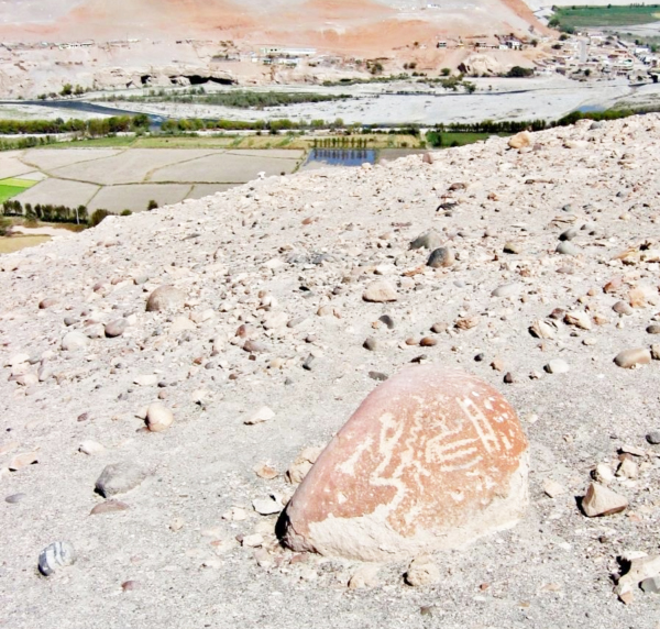
suitable rock surfaces; in this case the deeply patinated, ‘red’ boulders. This type of red stone is very common in this part of the Andes. I am convinced that the ancient Andean manufacturers preferred this type of red stone because the newly made images clearly stood out in sharp contrast with the original, patinated surface of the stone. In most cases the resulting image was clearly white on a red background. This is what I would like to call the micro-level of contrasting colours. Due to weathering illustrative examples do no longer occur at El Olivar, but Boulder AP3-099 at Alto de Pitis, in the Majes Valley of southern Peru (Figure 7), is a fine example. Indeed, many images fade or disappear completely over time. Petroglyphs on Boulder CNG-019 at Cerro Negro in Chicama (Figure 8) perfectly show the difference between deeply patinated lines (red arrow) and fresh white lines (yellow arrow - a recently made or recently re-pecked image?). This red-white contrast proves to be important in the worldview of many ancient Andean cultures.

Figure 7. Boulder AP3-099 at Alto de Pitis, in the Majes Valley of southern Peru.
Photograph © by Maarten van Hoek, 2015.

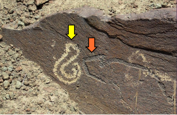
Figure 8. Boulder CNG-019 at Cerro Negro in Chicama, northern Peru.
Photograph © by Maarten van Hoek, 2015.

Strikingly, the environment at El Olivar displays another red-white contrast; on a macro-level this time. I notably observed that the immediate neighbouring landscape also features the opposites (literally) of red and white. The decorated red boulders are notably part of the small hill (summit at about 410 m O.D.; the west end of Cerro Colorado - Red Hill) just east of the Cupisnique road. This hill is covered by small and medium sized red boulders (Figure 9). Directly opposite the red slopes of Cerro Colorado and on the west side of the road is the clearly white mountain top of Cerro Cahuacucho (3 in Figure 4; its peak at about 556 m O.D.) that dominates the site (Figure 10).

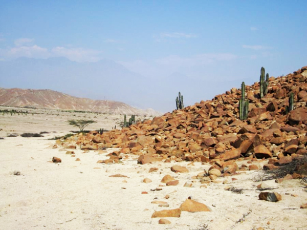
Figure 9. The red SE slopes of Cerro Colorado, looking east.
Photograph © by Maarten van Hoek, 2015.

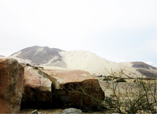
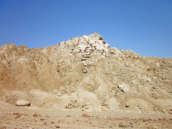
Figure 10. The clearly white mountain top of Cerro Cahuacucho, looking SW.
Photograph © by Maarten van Hoek, 2015.


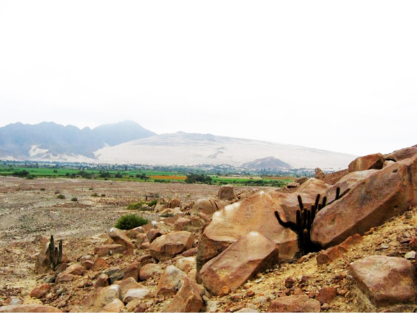
But there is more. The petroglyph site of El Olivar is located in a small pass (running NW-SE for 1.2 km between the red hill and the white mountain). To the south, at a point where several ancient structures are visible (including the possible Tambo; 11 in Figure 6), this pass opens onto the Pampa Colorado (Red Pampa). To the north this pass directly connects with a large, east-west running alluvial plain between Cerro Colorado and Cerro San Pedro in which there is a sharp contrast between the higher parts of the alluvial fans (5 in Figure 4) and the lower parts of the wide and shallow river bed of Quebrada Tucushuanca (4 in Figure 4) in which the seasonal waters intermittently flow. The higher parts consist of deeply red and brown stones (gravel and boulders), while the dry riverbed comprises white boulders, gravel and sand. The contrast is most eye-catching (Figure 5; see video).

If the situation at El Olivar were an isolated case, I would not have mentioned those facts. Although at several places red boulder fields have been ignored for petroglyph production, very many other instances where red rock panels have been selected for petroglyph production are found in this part of the Andes. Several of those sites are set in a landscape where such contrasting elements of red and white occur or even dominate.

In numerous cases red petroglyph panels (boulders or outcrops) are found in a white (grey or yellow) setting of sand and/or gravel, like at Guayaquil, Las Piedras Negras, Pocos, Alto de la Guitarra, Huaca Blanca, Alto de Pitis, Illomas, Gayalopo, Palamenco, Mollebaya Chico, La Caldera, Tacar and Motocachy Pampa (Figure 11), just to name a few.

Figure 11. The boulder field of Motocachy Pampa, Ancash, northern Peru, looking SE.
Photograph © by Maarten van Hoek, 2015.

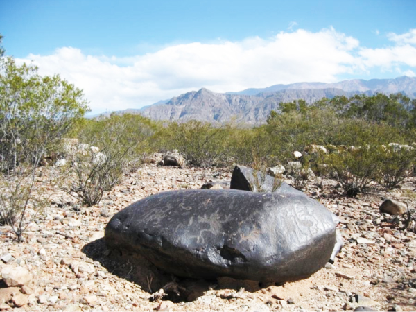
Other red boulders or boulder fields are found near white, usually dry river beds, like the petroglyph sites of Santa Rita, Cerro Negro, Muralla and Pakra (Figure 12), Pampa Grande (Fig. 6), Palamenco, Motocachy Pampa, El Vagón, Los Tres Cerritos, Queneto and of course El Olivar (Figure 4). At other sites red petroglyph boulders contrast sharply with a backdrop of huge white dunes, like the sites of Tolón in Jequetepeque (Figure 13) and Queneto and Quebrada de San Juan (Figure 14) in Virú. Also the contrast between the high-altitude zone of red stone selected for petroglyph production and the surrounding dark-grey mountains at Chillihuay in southern Peru is striking.

Figure 12. Muralla, bordering the Río Pisco, central Peru, looking SW.
Photograph © by Maarten van Hoek, 2015.

Figure 13. The boulder field of Tolón, northern Peru, looking SW towards a huge dune
on top of Cerro Tira Larga. Photograph © by Maarten van Hoek, 2015
.
Figure 14. The boulder field of Quebrada de San Juan, northern Peru, looking SE
towards a large dune on Cerro Zaraque. Photograph © by Maarten van Hoek, 2015
.

It is even possible that red stone was especially selected at a spot where white, snow-capped volcanoes or mountain tops are visible. This may be the case at the petroglyph sites of La Isla and Santa Barbara on the Río Loa in northern Chile and, in particular, at Alto de Pitis on the east bank of the Río Majes in southern Peru. The situation at Alto de Pitis deserves more attention.

Alto de Pitis

What intrigued me deeply during my surveys in the Majes Valley of southern Peru were the several contrasting colours that could be seen at and from Alto de Pitis. Most fascinating and telling is the contrast between the monotonous grey desert and two small, but most conspicuous Red Spots in the hill sides opposite Alto de Pitis. The most eye-catching Red Spot is just above the hamlet of Punta Colorada (Red Spot) (Figure 15). The second Red Spot is located just above the hamlet of La Candelaria. These two Red Spots (6.5 km apart) also seem to frame the ‘entrance’ to the enormous rock art complex of Toro Muerto.

Many of the rocks at Alto de Pitis seem to have been chosen by the ancient manufacturers of the petroglyphs because of the colours of the stones themselves. Notably, many stones have colours that reflect the Red Spots on the opposite hill sides (Figure 15). Several petroglyph stones and/or rock panels are (almost) completely brownish-red, but the majority of boulders has surfaces that show a mixture of areas with a deep brownish-red patination that stands out against the rest of the yellowish or grey rock surface. Especially when viewed against the grey sands, the red colour of the boulders stands out and reminded me - in the field - of the Red Spots.

Figure 15. Petroglyph boulder at Alto de Pitis, Valle de Majes, southern Peru, looking west.
Photograph © by Maarten van Hoek, 2015.

It is now very likely that this specific area was chosen by ancient cultures because of those Red Spots and the red boulders. Universally red is the colour of blood and it is possible that also the ancient Majes people regarded the Red Spots as points where ‘the underworld was bleeding’ and where ‘blood’ and/or supernatural power surfaced into the natural world. Yet, another interpretation of the colours red and white is possible. This reading involves the concept of symbolic inversion. For instance, the Moche from northern Peru visually represented a specific aspect of dualism by opposition through contrasts of shape and colour.

In this symbolic inversion, the colours red and white reflect the realms of respectively life and death, like the white of bleached skeletons and the red of living beings. The symbolism of colours is even extended to the genital portions of skeletal individuals in Moche iconography, whose penis-tips were invariably painted red; the source of vitality is symbolized by the colour of life (Bourget & Taylor 2010). This specific dualistic concept of inversion may also apply to the colours of the landscape around Alto de Pitis: the white desert represents death, like bleached bones; the Red Spots represent life. Also interesting is the fact that when the Majes manufactured their images, the initially un-patinated, deep white petroglyphs contrasted sharply with the patinated (often red) natural surface of the rock. But, most importantly, there is more ‘white’ in the area. There is another remarkably white and impressive landmark visible from Alto de Pitis.

In my opinion the remarkable concentration of (often idiosyncratic) petroglyphs at Alto de Pitis can only be explained by the fact that the white ice-cap of the Nevado Coropuna is clearly visible. Indeed the long, ice-capped ridge of the Nevado Coropuna, located about 82 km to the NNW, is clearly perceptible on clear days. Besides its visibility from Alto de Pitis, another fact is important. Notably, this volcano, at 6425 m O.D. the highest and biggest volcano of Peru, was - and probably still is - one of the most important Sacred Mountains (Apus) of the Andes in Pre-Columbian times. I regard the ice-cap of the Nevado Coropuna as the major focal point where the mortal world could make contact with the ‘World of the Living Dead’. There is no doubt in my mind that the visibility of such a powerful ‘Apu’ would trigger certain rituals in the area, thus especially at Alto de Pitis; rituals that also involved the production of a unique group of rock art images (further details in Van Hoek 2013). Importantly, Alto de Pitis is the only rock art site in the Majes Valley where both the two Red Spots and the white ice-cap of the Nevado Coropuna can clearly be seen at the same time from (often red coloured) boulders with white petroglyphs. Thus, Alto de Pitis is the only spot in the Majes Valley where the observation of the surrounding landscape involves a specific aspect of dualism through opposition of contrasting colours; the Red Spots (life) and the white ice-cap of Apu Coropuna (death).

This life-death dualism may be appreciated in other situations. The red boulder may denote death and the white symbol may represent life. Likewise, the loose, drifting sands of the white desert dunes may be regarded to symbolise life, while the solid, immovable boulder may represent death. Equally, the white, dry river beds may stand for life, while the adjoining red boulder fields represent death. As life and death are not separate, conflicting phases in Andean cosmology (they are part of the cycle of life), the concept of symbolic inversion may equally dictate that the arid river bed represents death and the red boulders life.

Andean Petroglyph Art and Yanantin

It proves that the contrasting colours ‘red’ and ‘white’ were, and still are, important in Andean worldview. Apart from the initially white petroglyphs on red rock panels and opposing white and red landmarks, there are more instances in the Andean legacy that emphasise the importance of (those) contrasting colours. For instance, the Formative Period Temple Complex of Kuntur Wasi in Cajamarca, northern Peru, features four impressive and menacing sculptured stone faces in a sunken rectangular Plaza with two white monoliths and two red monoliths facing each other. The confined area of the rectangular Plaza unites those four monoliths in a perfect harmonisation of a cross (Kato 1993: 226-227; Onuki 2008: 209. Dr. Rebecca Stone-Miller (1995: 40) describes the Black and White Portal of the New Temple at Chavín de Huántar as examples of duality and complementarity underscored with natural colour.

Also during traditional despacho ceremonies the contrasting colours of red and white often play an important role (Armstrong 1990). This ancient Andean ritual, which may be regarded to be a form of Haywarisqa’ (the Quechua term for ‘despacho’), is designed to show the Apu (Sacred Mountain) how much the people valued their herds and also how well they have taken care of their animals since the previous year. In certain despachos red wine is offered to Pacha Mama (Mother Earth) while white liquor (often pisco) is offered to the Apus (the spirits of) the Sacred Mountains. In other rituals red flower petals for Pacha Mama and white petals for the Apus are laid in certain patterns, depending on the intent (Beeler 2013). This dualism proves to be an important concept in Andean cosmology.

Stone-Miller defines Andean worldview by four important features. One of those features is reciprocity, a feature of corporate worldview; one part is countered by and connected to another. Stone Miller continues to say that reciprocal or dualistic thinking is so pervasive that it seems to have influenced visual perception. For instance, [the Incas] saw the light and the dark [of the night sky] as equal opposites. Andean art has an emphasis on opposites interlocked, on pairs, doubling and mirror-images of all kinds (1995: 14-16). Dr. Hillary Webb formulates the same concept as follows, though markedly differently (2012: 70): One of the most well-known and defining characteristics of indigenous Andean thought is its adherence to a “complementary dualism” in which the “opposites” of existence are viewed as interdependent parts of a harmonious whole.

Importantly, Hillary Webb also narrates of a despacho where an Andean shaman used a large, white piece of paper, to create a kind of pattern upon (the two fragments in italics - my emphases - will be explained further down). This pattern was made from a variety of objects, each of which carried with it a specific intent for the health of individual, community, and planet. One of the first symbols to be included within the offering was a small figurine in the form of a human being. The figure was split down the middle, with one half of it coloured yellow [which may be read as ‘white’], the other half, pink [which may be interpreted as ‘red’]. “This is yanantin,” the shaman told Dr. Webb, “complementary opposites.” (2012: 74-75; remarks in italics between [ ] have been added by me). This bi-coloured despacho figurine may be compared with the impressive rock paintings of large anthropomorphic figures in the huge rock shelter of San Borjita (PDF) on the Baja California peninsula, Mexico. Perhaps the bi-coloured figures of San Borjita express the same symbolism. Comparable bi-coloured rock paintings also have been reported from the Columbia Plateau in NW of the USA (Keyser 1992: Figs 50 a and c).

Moreover, Amado Quispe, a young shaman and the primary research participant of Dr. Webb stated: For us, yanantin doesn’t focus on the differences between two beings. That is what disconnects them. Instead, we focus on the qualities that brought them together. … One on its own can’t hold everything, can’t take care of everything. Not only are they great together, but they need to be together. … When there is another, it represents extra strength for both. (Webb 2012: 75).

Merging the concept of yanantin with the rituals of petroglyph production is the next logical step in my line of reasoning. Although I spoke of ‘red’ and ‘white’ throughout this paper, the colours do not really matter. In this paper, it is the contrast that matters. For instance, the intense black and shiny boulders at the petroglyph site of Parque Diaguita in western Argentina once literally and metaphorically reflected the same meaningful contrast when symbols were pecked out of the deeply patinated surface. This contrast has almost completely disappeared at the moment, but re-appears when observed from a certain angle. Boulder DIA-W-008 at Parque Diaguita (Figure 16; many more photos available in my video) offers a good example of two different types of patinated images, the more deeply patinated images are best visible with reflecting sunlight (Van Hoek 2014b). At Yonán in northern Peru the petroglyphs have been manufactured on grey-blue panels. Toro Muerto, also in Peru, has many grey, yellowish and whitish panels. However, freshly made images are almost invariably much whiter. Yet, I still argue that the red-white contrast is the most desired and the most meaningful contrast in Andean worldview.

Figure 16. Boulder DIA-W-008 at the petroglyph site of Parque Diaguita in western Argentina, looking west. Photograph © by Maarten van Hoek, 2015.

Thus, the ritual of image-making resulted in a bright symbol on a dark background; an ensemble for which can also be stated: “Not only are they great together, but they need to be together” (Amado Quispe, in: Webb 2012). The contrasting colours are not in conflict with each other; on the contrary, they build a harmonious whole in which the natural qualities of the red stone are connected with the anthropic meaning of the newly created, white symbol. The red stone is part of and may be regarded to represent/symbolise Pacha Mama, while the white symbol may represent a message to the spirits of the Apus. Thus, simultaneously, the whole picture of the complementary opposites (red boulder and white image) conveys a message. The white symbol would be meaningless without the red surface of the stone that supports it and vice versa.

Interestingly, those messages are largely (or completely) incomprehensible for us western researchers and even for many modern Andeans, as both the contrast and the meaning notably fade over time. The naturally fading symbols, but also the changing worldview, may be the reason why images have often been re-pecked, altered and even obliterated (Van Hoek 2005, 2006) by members of the same culture or by later cultures. Sadly, it also explains vandalism, which is so damaging to the invaluable legacy of ancient cultures.

Petroglyph Art and Information

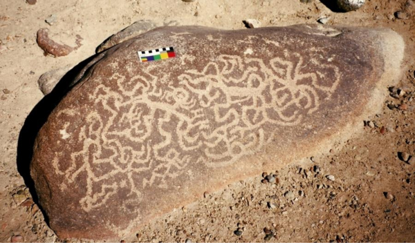
Interestingly, the ancient Andeans applied - without realising this, of course - the concept of entropy, which - in physics - is a fundamental part of the second law of thermodynamics. Simply said this concept reads: the more entropy, the more disorder and the more probability. Thus, chaos is a more likely situation. However, also in information-science entropy is a measure of disorder or chaos, and then it can be read as: the lower the entropy, the less chaos and the more information. An example will clarify this. A completely white piece of paper (compare this with the despacho ritual mentioned above) conveys no information; there is no difference; all parts of the paper are equal. This state of complete lack of information represents maximum entropy, total chaos or complete disorder. Only when contrast is added onto the paper (for instance in the form of black letters, a colour-drawing or a pattern of objects as used in a despacho) the whole (paper and pattern) conveys information, thus decreasing the entropy or chaos.

Then it does not matter whether the pattern is (in)decipherable to a western rock art researcher. The pattern conveys information that is only legible and meaningful for the manufacturer and for the initiated and also for the informed participants/observers. No matter how simple or how chaotic a petroglyph pattern is (see for instance Figure 17), for the manufacturer it represented vital (!) information that she or he wished to share with her or his gods, his or her ancestors, spirits or (certain) fellow members of the group. Importantly, the creation of petroglyphs (in fact the creation of any kind of rock art) increases the amount of information and thus inevitably decreases chaos. Why is this conclusion so important for Andean (and also global) cosmology?

Figure 17. Boulder MIM-010 at the petroglyph site of Miculla in southern Peru, looking west.
The observant observer may spot at least two zoomorphic figures hidden in the chaos of lines
(the brain is trained to look for information). Photograph © by Maarten van Hoek, 2015
.

The Andean physical world is one of the most restless and active areas on earth. Earthquakes, volcanic eruptions, landslides, tidal waves, El Niño's, droughts and floods repeatedly confronted Andean societies with chaos and disorder. On top of that, military forces often invaded (other) Andean cultures, which added to the chaos and stress. On the other hand, the natural world supplied (and still supplies) an abundance of seafood and fertile river valleys (immediately bordered by barren deserts). This strongly contrasting dualism of negative forces and positive properties shaped the religious beliefs of almost every Andean society. As a result, an important property of Andean ritual concerns the concept of maintaining a cosmic order, which involves mediation of the opposing forces to create a condition of harmonious balance. However, mediation never resulted in an enduring equilibrium and disasters occurred, time after time. From an Andean perspective such disasters happened because of human disregard of the religious tenets, which disturbed the delicate balance. Then a (part-time) shaman or a (full-time) priest had to enter the supernatural world in order to mediate the dualistic forces and to direct the powers to benefit the community. Consequently, one had to find a way to communicate with both the supernatural and the common people in a convincing and enduring way.

In this respect, it must be realised that ancient Andean societies did not have a system of writing. All events are perpetuated through verbal communication and symbolic representation. The repeated ritual re-enactment of beliefs and their representation through selected imagery served a religious purpose and ensured the circulation to the entire community. Rock art is one of the most important means of communication in Andean societies and rock art sites certainly are sacred places where repeated ritual execution of selected imagery expressed the concern of maintaining the cosmic equilibrium and preventing chaos. The images at El Olivar prove to be no exception. The red and white contrasts at this site (and many others) once were part of the goal to maintain the cosmic equilibrium.


CONCLUSIONS

El Olivar is a petroglyph site typical for this part of the Andes. Itself being a sacred site, it is associated with religious centres (Huacas) in a fertile river valley and simultaneously with infrastructure that crosses the barren desert connecting lush river valleys (although there is no scientific evidence yet that the art is indeed contemporary with either the Huacas or the infrastructure). But it is obvious that El Olivar is located on a crossroads of horizontally and vertically organised traffic of goods and people and thus also of religious concepts. The site, the (petroglyph) rocks and the images, all were important and revered in ancient times.

Even today several Andean rock art sites are venerated by local people. It is telling that the north end of the Cupisnique Road at El Olivar has been turned into a modern cemetery with a large Christian cross inside (see video). Moreover, Llosa Giraldo (2011) includes a photograph of Panel OVR-002A in front of which is a assortment of coca leaves that he claims to be offerings (Se puede observar còmo todavia se le hace "pagos" con coca y cigarrillo a estos personajes. [the ‘personajes’ being the enigmatic anthropomorphic petroglyphs on that boulder at El Olivar; see video]). Interestingly, coca leaves also embody the concept of yanantin, of complementary opposites, as they have a brighter (silvery) and a darker (green) side (Armstrong 1990: 125).

Moreover, the initially white symbols of El Olivar were manufactured on red and blackish boulders, while the surrounding landscape still reflects the white-red contrast. Red boulder and white image, but also red landmark (for instance a hill) and white landmark (for instance a dry riverbed or a dune) are complementary opposites in Andean cosmology; they are yanantin. Those opposites must not been seen as emphasising the differences, but as two opposing elements that need to be together in order to form a harmonious whole, whether this whole is a petroglyph boulder or a landscape. In my opinion the ritual of manufacturing and/or observing this whole (symbol and background) can be interpreted as a way (literally and metaphorically) to create and convey information in order to decrease the chaos in the chaotic Andean world.

ACKNOWLEDGMENTS

I would like to thank Mrs Giuliana Melendez and especially Mrs Lucha Mendiola Lomparte, both from Casma, for making it possible for us to explore the Casma area and especially the Sechín valley. Without the help and determination of Mrs Lucha Mendiola Lomparte and the much appreciated assistance of several locals from El Olivar we would never have been able to survey El Olivar. I am also indebted to Mrs Meg Beeler for her permission to use information from her web site, and to Dr. David Johnson and Dr. Carlos Zapata Benites for providing useful information about Pampa Colorada. As ever I thank my wife Elles for her assistance in the field and her support at home.

¿Preguntas, comentarios? escriba a: rupestreweb@yahoogroups.com


Cómo citar este artículo
:

van Hoek, Maarten. Andean Petroglyphs and Yanantin The Case of El Olivar, Ancash, Peru.
En Rupestreweb, http://www.rupestreweb.info/yanantin.html


2015


REFERENCIAS BIBLIOGRÁFICAS
(all hyperlinks functioning in March 2015)

Armstrong, G. 1990. Symbolic arrangement and communication in the Despacho. PhD. Thesis. University of St. Andrews, Scotland.

Beeler, M. 2013. The Despacho Ceremony. Earth Caretakers.

Benfer, R. A. 2011. Giant Preceramic animal effigy mounds in South America? Antiquity. Vol. 085, Issue 329.

Bourget, S. & A-C. Taylor. 2010. Sex, death and sacrifice in the Mochica religion. Exhibition Dossier. Musée du Qauy Branly, Paris.

Castillo Benites, D. S. 2006. Arte Rupestre en la Cuenca del Río Chicama. Ediciones SIAN, Arqueología / 4. Trujillo, Perú.

Hostnig, R. 2003. Arte rupestre del Perú. Inventario Nacional. CONCYTEC, Lima, Perú.

Johnson, D. and A. Rodriguez. 2009. Geoglyph patterns on the Pampa Colorada, Casma, Peru. Privately Published: Global Learning Inc. New York. (Text-PDF and Illustrations-PDF are no longer available on-line; contact the author for copies).

Johnson, D. and A. Rodriguez. 2010. Geoglyph patterns on the Pampa Colorada, Casma, Peru, and other nearby sites. In: David Johnson: Beneath the Nasca Lines and Other Coastal Geoglyphs of Peru and Chile; Chapter 5. Privately Published: Global Learning. New York.

Keyser, J. D. 1992. Indian Rock Art of the Columbia Plateau. University of Washington Press, Seattle, USA.

León Ascurra, W. 1996. “Los Geoglifos de Pampa Colorada - Casma”. In: Queymi. Revista de Cultura Regional y Nacional, N° 35. pp. 24 - 29. Segunda Época. Huaráz, Instituto Nacional de Cultura.

Llosa Giraldo, A. 2011. Petroglifos de El Olivar a punto de ser destruidos. In: Manchan Casma.

Pozorski, S., T. Pozorski & J. Rick. 1991. A bird geoglyph near Casma, Peru. Andean Past, Vol. 3: pp. 87 - 192.

Proulx, D. A. 1973. Archaeological Investigations in the Nepeña Valley, Peru. Anthropology Research Reports - Research Report 13. University of Massachusetts, Amherst, USA.

Suárez Ubillúz, M. 2006. Los petroglifos de Yautan: Nuevas evidencias de arte rupestre en el Valle medio de Casma. Arkeos. Vol. 1 - Nr. 5. Revista Electroníca de Arqueología PCUP. Lima.

Stone-Miller, R. 2002. Art of the Andes: From Chavín to Inca. London: Thames & Hudson.

Van Hoek, M. 2005. Toro Muerto, Peru: Possible Prehistoric Deletion of Petroglyph Details. Adoranten 2005, pp. 73 - 80. Underslös, Sweden.

Van Hoek, M. 2006. Toro Muerto, Perú. Posibles alteraciones prehistóricas en detalles de petroglifos. In: Rupestreweb.


Van Hoek, M. 2011. The Chavín Controversy. Rock Art from the Andean Formative Period. Privately published
(BLURB). Oisterwijk, the Netherlands.

Van Hoek, M. 2013. The Carcancha and the Apu; Rock Art in the Death Valley of the Andes. Privately published (BLURB). Oisterwijk, the Netherlands.

Van Hoek, M. 2014a. The Motocachy Pampa Distaster, Peru; A Tale of Neglect of Rock Art.

In: TRACCE, On-line Rock Art Bulletin; and in: Rupestreweb.

Van Hoek, M. 2014b. Reflecting (on) Petroglyphs: Two Cases. In: TRACCE, On-line Rock Art Bulletin.

Van Hoek, M. 2015. A new geoglyph (?) in Nepeña, Northern Peru. In: Rupestreweb.

Webb, H. S. 2012. The Splendid and the Savage: The Dance of the Opposites in Indigenous Andean Thought. Journal of Transpersonal Research. Vol. 4 (1), pp. 69 - 93.